Mount Gipps, Queensland
Mount Gipps is a locality in the Scenic Rim Region, Queensland, Australia.[2] It borders New South Wales [3] and is one end of the Queensland rabbit-proof fence.[4]
| Mount Gipps Queensland | |||||||||||||||
|---|---|---|---|---|---|---|---|---|---|---|---|---|---|---|---|
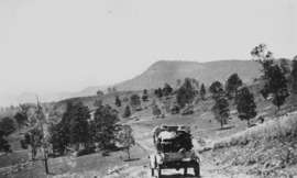 Mount Gipps on McPherson Range, 1928 | |||||||||||||||
 Mount Gipps | |||||||||||||||
| Coordinates | 28°19′20″S 153°00′34″E | ||||||||||||||
| Population | 7 (2016 census)[1] | ||||||||||||||
| Postcode(s) | 4285 | ||||||||||||||
| Location |
| ||||||||||||||
| LGA(s) | Scenic Rim Region | ||||||||||||||
| State electorate(s) | Scenic Rim | ||||||||||||||
| Federal Division(s) | Wright | ||||||||||||||
| |||||||||||||||
Geography
Mount Gipps has high slopes to the south (including the mountain Mount Gipps) belonging to the McPherson Range and also in the north-east with a valley through the north-west and from west to east. Running Creek, a tributary of the Logan River, flows from east to west through the locality. Mount Gipps Road enters from Chinghee Creek in the north-west and follows through the valley. Although entirely freehold land, only the lower valley areas have been cleared and are used for grazing. The slopes have an extensive tree cover.[5]
History
In 1900, much of the land in the upper reaches of Running Creek was part of the rural property Telemon Crossing owned by A. Drynan.[6]
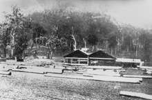
There was a sawmill in Mount Gipps from at least 1920.[7] It was located in the valley.[8]
Mount Gipps State School was opened on 21 July 1920.[9][10] It closed on 30 June 1954.[11][12]
Demographics
Mount Gipps has a population of 7 at the 2016 census. The locality contains 8 households, in which 30.0% of the population are males and 70.0% of the population are females with a median age of 52, 14 years above the national average. The average weekly household income is $0, $1,438 below the national average.[1]
Education
There are no schools in Mount Gibbs. The nearest primary school is Hillview State School in Hillview. The nearest secondary school is Beaudesert State High School in Beaudesert .[13]
References
- Australian Bureau of Statistics (27 June 2017). "Mount Gipps". 2016 Census QuickStats. Retrieved 25 January 2020.

- "Mount Gipps (entry 45173)". Queensland Place Names. Queensland Government. Retrieved 21 August 2015.
- "Queensland Globe". State of Queensland. Retrieved 4 May 2020.
- "Information on the Darling Downs-Moreton Rabbit Board". Darling Downs-Moreton Rabbit Board. 28 January 2015. Archived from the original on 26 February 2015. Retrieved 21 August 2015.
- "Queensland Globe". State of Queensland. Retrieved 26 August 2015.
- "From Lara to Cannon and Knapp's Creek". Queensland Country Life. 25 June 1900. p. 18. Retrieved 26 August 2015 – via National Library of Australia.
- "Meeting at Mount Gipps". The Worker. Brisbane. 25 November 1920. p. 16. Retrieved 26 August 2015 – via National Library of Australia.
- "AT BEAUDESERT". The Brisbane Courier. 27 June 1922. p. 7. Retrieved 26 August 2015 – via National Library of Australia.
- "Public Works". The Telegraph. Brisbane. 10 October 1919. p. 4. Retrieved 26 August 2015 – via National Library of Australia.
- "THE WEEK'S NEWS IN BRIEF". The Week. Brisbane. 4 June 1920. p. 23. Retrieved 26 August 2015 – via National Library of Australia.
- "Opening and closing dates of Queensland Schools". Queensland Government. Retrieved 26 August 2015.
- "Agency ID 9136, Mount Gipps State School". Queensland State Archives. Retrieved 26 August 2015.
- "Queensland Globe". State of Queensland. Retrieved 3 May 2020.
External links
| Wikimedia Commons has media related to Mount Gipps, Queensland. |
- "Macpherson Range". The Week. Brisbane. 26 July 1929. p. 8. Retrieved 26 August 2015 – via National Library of Australia. — a description of the MacPherson Ranges in 1929, including Mount Gipps area