Carneys Creek, Queensland
Carneys Creek is a locality in the Scenic Rim Region, Queensland, Australia.[2] It borders New South Wales.[3]
| Carneys Creek Queensland | |||||||||||||||
|---|---|---|---|---|---|---|---|---|---|---|---|---|---|---|---|
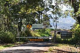 Entrance to Main Range National Park | |||||||||||||||
 Carneys Creek | |||||||||||||||
| Coordinates | 28.2113°S 152.5350°E | ||||||||||||||
| Population | 51 (2016 census)[1] | ||||||||||||||
| • Density | 0.506/km2 (1.312/sq mi) | ||||||||||||||
| Postcode(s) | 4310 | ||||||||||||||
| Area | 100.7 km2 (38.9 sq mi) | ||||||||||||||
| LGA(s) | Scenic Rim Region | ||||||||||||||
| State electorate(s) | Scenic Rim | ||||||||||||||
| Federal Division(s) | Wright | ||||||||||||||
| |||||||||||||||
History
Carney's Creek Provisional School opened in 1890. On 1 January 1909 it became Carney's Creek State School. It closed in 1914 due to low numbers of students. The school re-opened in 1920 but then closed again in 1921. It reopened in 1922. It closed permanently in 1970.[4]
Demographics
Carneys Creek has a population of 51 at the 2016 census. The locality contains 25 households, in which 59.1% of the population are males and 40.9% of the population are females with a median age of 55, 17 years above the national average. The average weekly household income is $1,062, $376 below the national average.[1]
gollark: It was done before, actually.
gollark: Technically they're slabs of metal and plastic.
gollark: Pine64 has a £25 one which might be neat.
gollark: They're cool.
gollark: $399£$
References
| Wikimedia Commons has media related to Carneys Creek, Queensland. |
- Australian Bureau of Statistics (27 June 2017). "Carneys Creek". 2016 Census QuickStats. Retrieved 30 September 2019.

- "Carneys Creek - locality in Scenic Rim Region (entry 46151)". Queensland Place Names. Queensland Government. Retrieved 8 November 2017.
- "Queensland Globe". State of Queensland. Retrieved 4 May 2020.
- Queensland Family History Society (2010), Queensland schools past and present (Version 1.01 ed.), Queensland Family History Society, ISBN 978-1-921171-26-0
This article is issued from Wikipedia. The text is licensed under Creative Commons - Attribution - Sharealike. Additional terms may apply for the media files.