Mutdapilly, Queensland
Mutdapilly is a locality in south-east Queensland, Australia. It is split between the local government areas of City of Ipswich and Scenic Rim Region.[1][2]
| Mutdapilly City of Ipswich, Queensland | |||||||||||||||
|---|---|---|---|---|---|---|---|---|---|---|---|---|---|---|---|
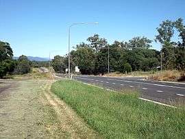 Cunningham Highway, 2015 | |||||||||||||||
 Mutdapilly | |||||||||||||||
| Coordinates | 27°44′32″S 152°39′51″E | ||||||||||||||
| Established | 1827 | ||||||||||||||
| Postcode(s) | 4307 | ||||||||||||||
| LGA(s) | |||||||||||||||
| State electorate(s) | Scenic Rim | ||||||||||||||
| Federal Division(s) | |||||||||||||||
| |||||||||||||||
Mutdapilly is centrally divided by the north/south running Cunningham Highway. The western boundary follows Warrill Creek. There is one of fifteen air quality monitoring stations in the region located at Mutdapilly.[3] It was established in 1995.
History
The name Mutdapilly is believed to be a combination word from the Yuggera language (Yugarabul dialect) where mudtherri means sticky or muddy and pilly means gully.[1][2] The name was given by Captain Patrick Logan on 9 June 1827.[4]
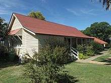
Local farmer, Mr Denman, donated 2 acres of land to build a school. The Normanby State School and teacher's residence was opened on 27 April 1874; the first head teacher was John Stanfell Clowes who served at the school until 31 July 1876. The school was renamed Mutdapilly State School on 1 April 1968.[5][6][7]
St Aidan's Church of England was built in Mutdapilly in 1921, designed by Charles Chauvel (the Australian filmmaker). It was dedicated on 15 April 1922 by Coadjutor Bishop Henry Le Fanu. The church closed in 1974 and the building is now used as a residence.[7][8][9]
Heritage listings
Heritage listings for Mutdapilly include:
- 4 Mutdapilly-Churchbank Weir Road: Mutdapilly State School[10]
Notable residents
- Charles Chauvel, early Australian filmmaker
- Terrence Bicknell, Pastoralist
References
- "Mutdapilly (Ipswich City) (entry 46553)". Queensland Place Names. Queensland Government. Retrieved 27 February 2014.
- "Mutdapilly (Scenic Rim Regional Council) (entry 45212)". Queensland Place Names. Queensland Government. Retrieved 27 February 2014.
- "South East Queensland". Air monitoring network stations. The State of Queensland. 9 May 2014. Retrieved 16 April 2015.
- "Indigenous Place Names" (PDF). Ipswich City Council. Retrieved 9 April 2015.
- "Opening and closing dates of Queensland Schools". Queensland Government. Retrieved 18 April 2019.
- "Agency ID 152, Mutdapilly State School". Queensland State Archives. Retrieved 27 February 2014.
- "Harrisville & District" (PDF). Ipswich City Council. Archived from the original (PDF) on 6 April 2011. Retrieved 27 February 2014.
- Starr, Joan (1988), Moreton Shire Queensland : discovery and settlement, Southern Cross PR and Press Services, ISBN 978-0-9588021-0-9
- "Closed Anglican Churches". Anglican Church South Queensland. Archived from the original on 3 April 2019. Retrieved 29 June 2020.
- "Mutdapilly State School (entry 602840)". Queensland Heritage Register. Queensland Heritage Council. Retrieved 17 December 2017.
Further reading
- Starr, Joan (1988), Moreton Shire Queensland : discovery and settlement, Southern Cross PR and Press Services, ISBN 978-0-9588021-0-9
External links
![]()