Maroon, Queensland
Maroon is a rural locality in the Scenic Rim Region, Queensland, Australia.[2] In the 2016 census, Maroon had a population of 149 people.[1]
| Maroon Queensland | |||||||||||||||
|---|---|---|---|---|---|---|---|---|---|---|---|---|---|---|---|
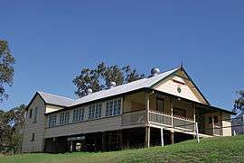 School of Arts, built 1904 | |||||||||||||||
 Maroon | |||||||||||||||
| Coordinates | 28.1919°S 152.6897°E | ||||||||||||||
| Population | 149 (2016 census)[1] | ||||||||||||||
| • Density | 1.281/km2 (3.318/sq mi) | ||||||||||||||
| Postcode(s) | 4310 | ||||||||||||||
| Area | 116.3 km2 (44.9 sq mi) | ||||||||||||||
| Time zone | AEST (UTC+10:00) | ||||||||||||||
| LGA(s) | Scenic Rim Region | ||||||||||||||
| State electorate(s) | Scenic Rim | ||||||||||||||
| Federal Division(s) | Wright | ||||||||||||||
| |||||||||||||||
Geography
The south and east of the area, including Mount May is protected within the Mount Barney National Park.
History
The locality name comes from wahlmoorum, which is the Yaggera language name for Mount Ballow, which is associated with a legendary giant sand goanna.[2]
The Maroon pastoral property was established in 1843.[3]
A cemetery at Maroon has graves dating back to 1856.[3]
Maroon Provisional School opened on 15 July 1891. On 1 January 1909 it became Moon State School.[4]
In 1914, the Maroon pastoral property was subdivided into 30 dairy farms.[3]
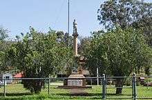
The Maroon War Memorial commemorates those of the district who enlisted in World War I; it was dedicated on 21 May 1920 by General Sir William Birdwood.[5]
Maroon Post Office opened on 1 July 1927 (a receiving office had been open from 1925) and closed in 1973.[6]
The Maroon Dam was built in the west of Maroon between 1969 and 1974.
Heritage listings
Maroon has a number of heritage-listed sites, including:
- Boonah-Rathdowney Road: Maroon War Memorial & Memorial Enclosure[7]
- 2772 Boonah Rathdowney Road: Maroon State School and Maroon War Memorial[8]
- Boonah-Rathdowney Road: St Andrew’s Anglican Church [9]
- Boonah Road: Cotswold Cottage[10]
- Newlove Road: Maroon School of Arts [9]
Education
Maroon State School is a government primary (Prep-6) school for boys at 2772 Boonah-Rathdowney Road (28.1716°S 152.7137°E).[11][12] In 2017, the school had an enrolment of 9 students with 4 teachers (2 full-time equivalent) and 5 non-teaching staff (2 full-time equivalent).[13]
Maroon Outdoor Education Centre is an Outdoor and Evironmental Education Centre at 123 Maroon Dam Road (28.1737°S 152.6511°E).[11][14]
Demographics
Maroon has a population of 149 at the 2016 census. The locality contains 25 households, in which 57.0% of the population are males and 43.0% of the population are females with a median age of 46, 8 years above the national average. The average weekly household income is $1,104, $334 below the national average.
2.8% of Maroon's population is either of Aborigional or Torres Strait Islander descent. 67.9% of the population aged 15 or over is either registered or de facto married, while 32.1% of the population is not married. 21.2% of the population is currently attending some form of a compulsory education. The most common nominated ancestries were English (36.4%), Australian (28.2%) and German (10.5%), while the most common country of birth was Australia (86.5%), and the most commonly spoken language at home was English (93.9%). The most common nominated religions were Anglican (36.2%), No religion (17.7%) and Catholic (16.3%). The most common occupation was a manager (25.9%) and the majority/plurality of residents worked 40 or more hours per week (58.6%).[1]
References
- Australian Bureau of Statistics (27 June 2017). "Maroon (SSC)". 2016 Census QuickStats. Retrieved 20 October 2018.

- "Maroon - locality in Scenic Rim Region (entry 45161)". Queensland Place Names. Queensland Government. Retrieved 30 November 2019.
- Environmental Protection Agency (Queensland) (2000). Heritage Trails of the Great South East. State of Queensland. p. 32. ISBN 0-7345-1008-X.
- Queensland Family History Society (2010), Queensland schools past and present (Version 1.01 ed.), Queensland Family History Society, ISBN 978-1-921171-26-0
- "Maroon War Memorial". Monuments Australia. Archived from the original on 13 January 2017. Retrieved 5 April 2014.
- Premier Postal History. "Post Office List". Premier Postal Auctions. Retrieved 10 May 2014.
- "War Memorial & Memorial Enclosure (entry 600036)". Queensland Heritage Register. Queensland Heritage Council. Retrieved 12 July 2013.
- "Maroon State School and Maroon War Memorial (entry 650004)". Queensland Heritage Register. Queensland Heritage Council. Retrieved 18 January 2018.
- "Local Heritage Register" (PDF). Scenic Rim Regional Council. Archived from the original (PDF) on 24 September 2015. Retrieved 9 February 2015.
- "Cotswold Cottage (entry 600037)". Queensland Heritage Register. Queensland Heritage Council. Retrieved 12 July 2013.
- "State and non-state school details". Queensland Government. 9 July 2018. Archived from the original on 21 November 2018. Retrieved 21 November 2018.
- "Maroon State School". Archived from the original on 19 April 2013. Retrieved 21 November 2018.
- "ACARA School Profile 2017". Archived from the original on 22 November 2018. Retrieved 22 November 2018.
- "Maroon Outdoor Education Centre". Archived from the original on 11 March 2017. Retrieved 21 November 2018.
External links
| Wikimedia Commons has media related to Maroon, Queensland. |