Shire of Omeo
The Shire of Omeo was a local government area about 390 kilometres (242 mi) east-north-east of Melbourne, the state capital of Victoria, Australia. The shire covered an area of 5,641 square kilometres (2,178.0 sq mi), and existed from 1872 until 1994.
| Shire of Omeo Victoria | |||||||||||||||
|---|---|---|---|---|---|---|---|---|---|---|---|---|---|---|---|
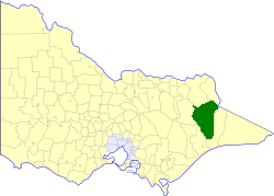 Location in Victoria | |||||||||||||||
| Population | 1,680 (1992)[1] | ||||||||||||||
| • Density | 0.2978/km2 (0.7713/sq mi) | ||||||||||||||
| Established | 1872 | ||||||||||||||
| Area | 5,641 km2 (2,178.0 sq mi) | ||||||||||||||
| Council seat | Omeo | ||||||||||||||
| County | Bogong, Benambra, Dargo, Tambo | ||||||||||||||
| |||||||||||||||
History
Omeo was incorporated as a shire on 25 October 1872.[2]
On 2 December 1994, the Shire was abolished, and merged with City and Shire of Bairnsdale, Shire of Tambo and the Boole Boole Peninsula from Shire of Rosedale into the Shire of East Gippsland. The Dinner Plain district merged into the Alpine Shire which had been created two weeks earlier.[3]
Wards
Omeo was divided into four ridings on 15 January 1957, each of which elected three councillors:
- Omeo Riding
- Ensay Riding
- Hinnomunjie Riding
- Tongio Riding
Towns and localities
- Benambra
- Brookville
- Cassilis
- Dinner Plain
- Doctors Flat
- Ensay
- Hinnomunjie
- Omeo
- Swifts Creek
- Tambo Crossing
- Tongio
- Uplands
Population
| Year | Population |
|---|---|
| 1954 | 2,072 |
| 1958 | 2,100* |
| 1961 | 2,145 |
| 1966 | 2,026 |
| 1971 | 1,858 |
| 1976 | 1,605 |
| 1981 | 1,565 |
| 1986 | 1,628 |
| 1991 | 1,920 |
* Estimate in the 1958 Victorian Year Book.
gollark: It's great for prototyping and simple app development!
gollark: MWAHAHAHAHA!
gollark: It's BOTH!
gollark: I'm programming a BAD SEARCH ENGINE in JAVASCRIPTS!
gollark: I am indeed using connect-flash.
References
- Australian Bureau of Statistics, Victoria Office (1994). Victorian Year Book. pp. 49–52. ISSN 0067-1223.
- Victorian Municipal Directory. Brunswick: Arnall & Jackson. 1992. pp. 796–797. Accessed at State Library of Victoria, La Trobe Reading Room.
- Australian Bureau of Statistics (1 August 1995). Victorian local government amalgamations 1994-1995: Changes to the Australian Standard Geographical Classification (PDF). Commonwealth of Australia. p. 4,6. ISBN 0-642-23117-6. Retrieved 5 January 2008.
This article is issued from Wikipedia. The text is licensed under Creative Commons - Attribution - Sharealike. Additional terms may apply for the media files.