Shire of Karkarooc
The Shire of Karkarooc was a local government area in northwestern Victoria, Australia. The shire covered an area of 3,719 square kilometres (1,435.9 sq mi), and existed from 1896 until 1995.
| Shire of Karkarooc Victoria | |||||||||||||||
|---|---|---|---|---|---|---|---|---|---|---|---|---|---|---|---|
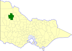 Location in Victoria | |||||||||||||||
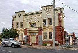 Shire of Karkarooc Memorial Hall in Hopetoun | |||||||||||||||
| Population | 2,720 (1992)[1] | ||||||||||||||
| • Density | 0.7314/km2 (1.894/sq mi) | ||||||||||||||
| Established | 1896 | ||||||||||||||
| Area | 3,719 km2 (1,435.9 sq mi) | ||||||||||||||
| Council seat | Hopetoun | ||||||||||||||
| County | Karkarooc | ||||||||||||||
 | |||||||||||||||
History
Land in Karkarooc was originally within the St Arnaud Road District, from 1861 and the Shire of St Arnaud, from 1864, and then within the Shire of Borung, after its severance from St Arnaud. Parts of the North and West Ridings of Borung severed on 29 May 1896, to form the Shire of Karkarooc. On 29 May 1897, it annexed the northeastern part of Shire of Dimboola, and two days later annexed part of Castle Donnington. On 31 May 1906, it also annexed part of the Tyrrell Riding of the Shire of Wycheproof.
A new shire, Walpeup, was formed in western Victoria on 1 October 1911, taking in some areas of Karkarooc and sections of five other shires. Karkarooc also lost some of its West Riding to Dimboola on 14 December 1932.[2]
On 20 January 1995, the Shire of Karkarooc was abolished, and, along with parts of the Shires of Dunmunkle, Warracknabeal and Wimmera, was merged into the newly created Shire of Yarriambiack.[3]
Karkarooc was, at the time of dissolution, not divided into ridings, and its twelve councillors represented the entire shire.
Towns and localities
Population
| Year | Population |
|---|---|
| 1954 | 4,424 |
| 1958 | 4,620* |
| 1961 | 4,168 |
| 1966 | 4,245 |
| 1971 | 3,729 |
| 1976 | 3,750 |
| 1981 | 3,119 |
| 1986 | 2,822 |
| 1991 | 2,610 |
* Estimate in the 1958 Victorian Year Book.
References
- Australian Bureau of Statistics, Victoria Office (1994). Victorian Year Book. pp. 49–52. ISSN 0067-1223.
- Victorian Municipal Directory. Brunswick: Arnall & Jackson. 1992. pp. 715–716. Accessed at State Library of Victoria, La Trobe Reading Room.
- Australian Bureau of Statistics (1 August 1995). Victorian local government amalgamations 1994-1995: Changes to the Australian Standard Geographical Classification (PDF). Commonwealth of Australia. p. 12. ISBN 0-642-23117-6. Retrieved 5 January 2008.