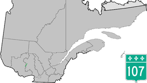
Quebec Route 107
Route 107 is a north/south highway on the north shore of the Saint Lawrence River. Its southern terminus is in Maniwaki at the junction of Route 105 and its northern terminus is in Grand-Remous at the junction of Route 117. Sections of the route near its northern terminus are gravel.
| ||||
|---|---|---|---|---|
 | ||||
| Route information | ||||
| Maintained by Transports Québec | ||||
| Length | 38.8 km[1] (24.1 mi) | |||
| Major junctions | ||||
| South end | ||||
| North end | ||||
| Location | ||||
| Counties | La Vallée-de-la-Gatineau | |||
| Highway system | ||||
| ||||
Municipalities along Route 107
- Maniwaki
- Déléage
- Aumond
- Grand-Remous
Major intersections
| RCM or ET | Municipality | Km | Junction | Notes |
|---|---|---|---|---|
Southern terminus of Route 107 | ||||
| La Vallée-de-la-Gatineau | Maniwaki | 0.0 | 105 SOUTH: to Gatineau 105 NORTH: to Grand-Remous | |
| Déléage | 5.7 | Chemin de Sainte-Thérèse-de-la-Gatineau | SOUTH: to Sainte-Thérèse-de-la-Gatineau | |
| Grand-Remous | 38.8 | 117 SOUTH: to Mont-Laurier 117 NORTH: to Val-d'Or | ||
Northern terminus of Route 107 | ||||
gollark: So expert. Much wow.
gollark: I have speed upgrades, just not energy upgrades.
gollark: Er, alloy smelter, totally not a furnace.
gollark: Stupid furnace! Smelt my ferroboron and lithium FASTER!
gollark: Is this You're an Expert Harry or something?
See also
References
- Ministère des transports, "Distances routières", page 56, Les Publications du Québec, 2005
External links
- Official Transport Quebec Road Map (Courtesy of the Quebec Ministry of Transportation) (in French)
- Route 107 on Google Maps
This article is issued from Wikipedia. The text is licensed under Creative Commons - Attribution - Sharealike. Additional terms may apply for the media files.
