Quebec Route 165
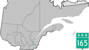
Route 165 is a 68 km north/south highway on the south shore of the Saint Lawrence River in Quebec, Canada. Its southern terminus is in Black Lake, now part of Thetford Mines, at the junction of Route 112 and its northern terminus is in Saint-Louis-de-Blandford at the junction of Autoroute 20. The stretch between Plessisville and Black Lake used to be Route 265 but it was re-numbered Route 165 in the 1990s.
| ||||
|---|---|---|---|---|
 | ||||
| Route information | ||||
| Maintained by Transports Québec | ||||
| Length | 67.3 km[1] (41.8 mi) | |||
| Major junctions | ||||
| South end | ||||
| North end | ||||
| Location | ||||
| Counties | Les Appalaches / L'Érable / Arthabaska | |||
| Major cities | Thetford Mines | |||
| Highway system | ||||
| ||||

Municipalities along Route 165
- Thetford Mines (Black Lake)
- Irlande
- Saint-Ferdinand
- Saint-Pierre-Baptiste
- Sainte-Sophie-d'Halifax
- Plessisville
- Plessisville (parish)
- Princeville
- Saint-Louis-de-Blandford
gollark: A gigabyte is probably a thousand books or more.
gollark: F
gollark: I think we generally underestimate how much a gigabyte actually *is* in terms of raw text and not "big-data" stuff like videos or images.
gollark: (minus images, revision history and talk pages and whatnot)
gollark: So I checked, and Wikipedia is actually 16.5GB now.
See also
References
- Ministère des transports, "Distances routières", page 73, Les Publications du Québec, 2005
External links
- Interactive Provincial Route Map (Transports Québec) (in French)
- Route 165 on Google Maps
This article is issued from Wikipedia. The text is licensed under Creative Commons - Attribution - Sharealike. Additional terms may apply for the media files.