Quebec Route 109
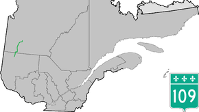
Route 109 is a Quebec provincial highway that runs through the western regions of Abitibi-Témiscamingue and Nord-du-Québec. It begins at Route 117 in Rivière-Héva, proceeding north approximately 59 km (36.7 mi) to Amos. From there, the highway extends 182 km (113.1 mi) to Matagami, where the road continues northwards as James Bay Road (French: Route de la Baie James). While now classified as a municipal road, the James Bay Road was part of provincial Route 109 until 2002. Consequently, some maps may still identify it as such.
| ||||
|---|---|---|---|---|
 | ||||
| Route information | ||||
| Maintained by Transports Québec | ||||
| Length | 222.7 km[1] (138.4 mi) | |||
| Major junctions | ||||
| South end | ||||
| North end | James Bay Road in Matagami | |||
| Location | ||||
| Counties | Abitibi / Jamésie | |||
| Highway system | ||||
| ||||

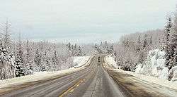
Typical winter scenery of Route 109 between Saint-Dominique-du-Rosaire and Matagami
The 182 km section of Route 109 between Saint-Dominique-du-Rosaire and Matagami winds through complete wilderness and no services exist at all here. There is however extensive logging taking place along this section.
Municipalities along Route 109
- Rivière-Héva
- La Motte
- Saint-Mathieu-d'Harricana
- Amos
- Saint-Félix-de-Dalquier
- Saint-Dominique-du-Rosaire
- Baie-James
- Matagami
Major intersections
| RCM or ET | Municipality | km | Junction | Notes |
|---|---|---|---|---|
Southern terminus of Route 109 | ||||
| Abitibi | Rivière-Héva | 0.0 | 117 SOUTH: to Val-d'Or 117 NORTH: to Rouyn-Noranda | |
| Amos | 39.3 | 111 SOUTH: to Val-d'Or | ||
| 395 SOUTH: to Preissac 395 NORTH: to Rochebaucourt | ||||
| 40.6 | 111 NORTH: to La Sarre | |||
| Jamésie | Matagami | 222.7 | James Bay Road | |
Northern terminus of Route 109 | ||||
gollark: This is troubling. `curl -X POST`ing osmarks internet radio's primary osmarks internet audio™ stream makes it... temporarily say "bad gateway"?
gollark: I don't think it's a particularly standardized English word, pick either.
gollark: Unfortunately, technology doesn't let you selectively erase memories yet.
gollark: Wait, what does your cron task *do* with the logs exactly?
gollark: I like to have a tab open in my terminal with `tail -f /var/log/nginx/access.log` open.
See also
References
- Ministère des transports, "Distances routières", page 56-57, Les Publications du Québec, 2005
External links
- Official Transport Quebec Road Map (Courtesy of the Quebec Ministry of Transportation) (in French)
- Route 109 on Google Maps
This article is issued from Wikipedia. The text is licensed under Creative Commons - Attribution - Sharealike. Additional terms may apply for the media files.
