Quebec Route 108
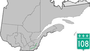
Route 108 is a two-lane east/west highway on the south shore of the Saint Lawrence River in the Eastern Townships and Chaudière-Appalaches regions of Quebec, Canada. Its eastern terminus is in Beauceville at the junction of Route 173, and the western terminus is at the junction of Route 112 in Magog.
| ||||
|---|---|---|---|---|
 | ||||
| Route information | ||||
| Maintained by Transports Québec | ||||
| Length | 177.9 km[1] (110.5 mi) | |||
| Major junctions | ||||
| West end | ||||
| East end | ||||
| Location | ||||
| Counties | Memphrémagog / Coaticook / Sherbrooke / Le Haut-Saint-François / Le Granit / Beauce-Sartigan | |||
| Highway system | ||||
| ||||

Municipalities along Route 108
Major intersections
| RCM or ET | Municipality | km | Junction | Notes |
|---|---|---|---|---|
Western terminus of Route 108 | ||||
| Memphrémagog | Magog | 0.0 | 112 WEST: to Orford 112 EAST: to Omerville | |
| 5.7 5.9 |
55 SOUTH: to Sainte-Catherine-de-Hatley 55 NORTH: to Omerville | |||
| Sainte-Catherine-de-Hatley | 12.5 | 216 EAST: to Sherbrooke | ||
| Coaticook | Waterville | 26.7 | 143 SOUTH: to Hatley | |
| Sherbrooke | Lennoxville | 30.0 | 147 SOUTH: to Compton | |
| 32.6 | 143 NORTH: to Sherbrooke | |||
| 37.6 | 251 SOUTH: to Martinville | |||
| Le Haut-Saint-François | Eaton | 48.8 | 210 EAST: to Newport | |
| Cookshire | 53.8 | 253 SOUTH: to Saint-Isidore-de-Clifton 253 NORTH: to Westbury | ||
| 54.1 | 212 EAST: to Newport | |||
| Bury | 61.9 63.4 |
214 WEST: to East Angus 214 EAST: to Scotstown | ||
| 66.9 | 255 NORTH: to Dudswell | |||
| Lingwick | 82.9 | 257 SOUTH: to Scotstown 257 NORTH: to Weedon | ||
| Le Granit | Stornoway | 105.5 | 161 SOUTH: to Nantes 161 NORTH: to Stratford | |
| Lambton | 120.1 122.1 |
263 NORTH: to Sainte-Praxède 263 SOUTH: to Saint-Sébastien | ||
| Beauce-Sartigan | La Guadeloupe | 140.7 | 269 SOUTH: to Saint-Honoré-de-Shenley | |
| Saint-Éphrem-de-Beauce | 146.1 | 269 NORTH: to Adstock | ||
| 152.6 | 271 SOUTH: to Saint-Benoît-Labre 271 NORTH: to Sainte-Clotilde-de-Beauce | |||
| Beauceville | 177.9 | 173 SOUTH: to Notre-Dame-des-Pins 173 NORTH: to Saint-Joseph-de-Beauce | ||
Eastern terminus of Route 108 | ||||
gollark: One of the models released for public use.
gollark: I believe Umnikos has used a GTech™ computer at some point.
gollark: Our computers aren't actually particularly bee-powered, at least directly.
gollark: Openbox (LXDE).
gollark: GTech™ experimental compute constellation 38.
.jpg)
References
- Ministère des transports, "Distances routières", page 56, Les Publications du Québec, 2005
External links
- Official Transport Quebec Road Map (Courtesy of the Quebec Ministry of Transportation) (in French)
- Route 108 on Google Maps
This article is issued from Wikipedia. The text is licensed under Creative Commons - Attribution - Sharealike. Additional terms may apply for the media files.