Grade II* listed buildings in East Dorset
There are over 20,000 Grade II* listed buildings in England. This page is a list of these buildings in the district of East Dorset in Dorset.
East Dorset shown in Dorset
East Dorset
| Name | Location | Type | Completed [note 1] | Date designated | Grid ref.[note 2] Geo-coordinates |
Entry number [note 3] | Image |
|---|---|---|---|---|---|---|---|
| Church of St Michael and All Angels | Colehill | Parish church | 1893–5 | 30 October 1987 | SU0247701213 50°48′38″N 1°57′58″W |
1323528 | 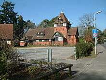 Church of St Michael and All Angels |
| Wilksworth Farmhouse | Colehill | Farmhouse | c. 1500 | 18 March 1955 | SU0073601896 50°49′00″N 1°59′27″W |
1120076 |  |
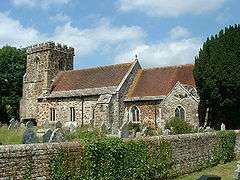
| Church of St Hubert | Corfe Mullen | Parish church | 13th century | 18 March 1955 | SY9767098350 50°47′05″N 2°02′04″W |
1303916 | 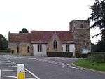 Church of St Hubert |
| Court House | Corfe Mullen | House | Late 16th century | 18 March 1955 | SY9764098595 50°47′13″N 2°02′05″W |
1120081 | 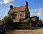 Court House |
| Carriage house approximately 80m north of Cranborne Lodge | Cranborne | Carriage house | Mid 19th century | 18 March 1955 | SU0561913224 50°55′06″N 1°55′17″W |
1120180 | |
| Cranborne Lodge | Cranborne | Country house | c. 1700 | 18 March 1955 | SU0559913136 50°55′04″N 1°55′18″W |
1304284 | _-_geograph.org.uk_-_605812.jpg) Cranborne Lodge |
| Gatehouse and south courtyard walls to Cranborne Manor House | Cranborne | Gatehouse | Early 17th century | 18 March 1955 | SU0531413182 50°55′05″N 1°55′33″W |
1304268 | |
| Church of St Nicholas | Edmondsham | Parish church | 14th century | 18 March 1955 | SU0611811543 50°54′12″N 1°54′52″W |
1154150 | 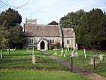 Church of St Nicholas |
| Edmondsham House | Edmondsham | Country house | 1589 | 18 March 1955 | SU0615511611 50°54′14″N 1°54′50″W |
1303958 | _-_geograph.org.uk_-_748912.jpg) Edmondsham House |
| Church of All Saints | Hampreston, Ferndown | Parish church | 14th century | 18 March 1955 | SZ0551898805 50°47′20″N 1°55′23″W |
1303912 | |
| Little Moors Farmhouse | Hampreston, Ferndown | Farmhouse | c. 1700 | 30 October 1987 | SZ0538299612 50°47′46″N 1°55′30″W |
1120046 | 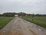 Little Moors Farmhouse |
| Abbey House | Horton | House | c. 1500 | 18 March 1955 | SU0302407398 50°51′58″N 1°57′30″W |
1120088 | |
| Horton Tower | Horton | Tower | 18 March 1955 | SU0304106743 50°51′37″N 1°57′29″W |
1120082 | 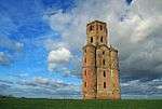 Horton Tower | |
| Stanbridge Bridge | Horton | Road bridge | Possibly medieval | 18 March 1955 | SU0137608878 50°52′46″N 1°58′55″W |
1323533 |  Stanbridge Bridge |
| Chapel of St Margaret and St Anthony | Pamphill | Leper hospital chapel | 13th century | 18 March 1955 | SU0041500364 50°48′10″N 1°59′44″W |
1304525 | 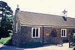 Chapel of St Margaret and St Anthony |
| High Hall | Pamphill | House | c. 1670 | 18 March 1955 | SU0008302806 50°49′29″N 2°00′01″W |
1119507 | |
| Lodge Farm House | Pamphill | House | Late 14th century | 18 March 1955 | ST9743102147 50°49′08″N 2°02′16″W |
1119474 | 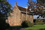 Lodge Farm House |
| Obelisk 140m south west of Kingston Lacy House | Kingston Lacy, Pamphill | Obelisk | 2nd century BC, relocated 1827 | 18 March 1955 | ST9779201128 50°48′35″N 2°01′58″W |
1323828 | |
| Pamphill Manor House | Pamphill Green, Pamphill | House | Late 17th century | 18 March 1955 | ST9898700628 50°48′19″N 2°00′57″W |
1120195 | 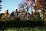 Pamphill Manor House |
| Church of St Mary | Sixpenny Handley | Parish church | 14th century | 18 March 1955 | ST9955617304 50°57′19″N 2°00′28″W |
1153750 | 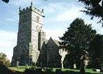 Church of St Mary |
| Almer Manor | Almer, Sturminster Marshall | House | c. 1600 | 18 March 1955 | SY9140898975 50°47′25″N 2°07′24″W |
1120056 | 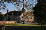 Almer Manor |
| Church of St Mary the Virgin | Sturminster Marshall | Parish church | 12th century | 18 March 1955 | ST9512100402 50°48′11″N 2°04′14″W |
1154649 | 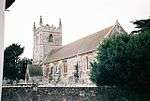 Church of St Mary the Virgin |
| Henbury Hall/Henbury House | Henbury, Sturminster Marshall | Country house | 18th century | 18 March 1955 | SY9567598223 50°47′01″N 2°03′46″W |
1120055 | |
| Church of All Saints and St Mark | West Parley | Parish church | 12th century | 18 March 1955 | SZ0865196844 50°46′16″N 1°52′43″W |
1120037 | 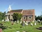 Church of All Saints and St Mark |
| Barclays Bank, 1 The Square | Wimborne Minster | House | 18th century | 14 June 1952 | SU0092500091 50°48′01″N 1°59′18″W |
1323777 | |
| Old Manor Farmhouse | Wimborne Minster | House | 16th century origin | 14 June 1952 | SZ0217899956 50°47′57″N 1°58′14″W |
1323810 | 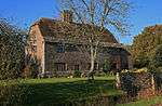 Old Manor Farmhouse |
| Priest's House Museum | Wimborne Minster | Hall house | Late 16th or early 17th century | 14 June 1952 | SZ0097199994 50°47′58″N 1°59′15″W |
1153246 | |
| Walford Bridge | Wimborne Minster | Bridge | Early 16th century | 14 June 1952 | SU0094200637 50°48′19″N 1°59′17″W |
1119538 | 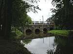 Walford Bridge |
| Wimborne Book Shop | Wimborne Minster | House | 18th century | 14 June 1952 | SU0081700032 50°47′59″N 1°59′23″W |
1323823 | |
| Wimborne Conservative Club | Wimborne Minster | House | Late 18th to early 19th century | 14 June 1952 | SU0092800140 50°48′03″N 1°59′18″W |
1153779 | 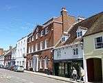 Wimborne Conservative Club |
| 43 West Borough | Wimborne Minster | House | 18th century | 14 June 1952 | SU0088400289 50°48′08″N 1°59′20″W |
1153942 | |
| Almshouses including front wall | Wimborne St Giles | Almshouses | c. 1624 | 18 March 1955 | SU0317011983 50°54′26″N 1°57′23″W |
1304115 | 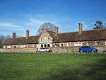 Almshouses including front wall |
| Grotto 250 metres south east of St Giles House | St Giles House, Wimborne St Giles | Grotto | 1750s | 3 April 1986 | SU0344811422 50°54′08″N 1°57′08″W |
1120131 |  Grotto 250 metres south east of St Giles House |
| Home Farm Buildings approximately 150 metres north east of St Giles House | St Giles House, Wimborne St Giles | Farm buildings | Early 16th century | 3 April 1986 | SU0330511698 50°54′17″N 1°57′16″W |
1120130 | |
| Abbey House | Witchampton | Manor house | Early 16th century | 18 March 1955 | ST9890206403 50°51′26″N 2°01′01″W |
1155304 | _-_geograph.org.uk_-_600175.jpg) Abbey House |
| Church of St Mary, St Cuthberga and All Saints | Witchampton | Parish church | 15th-century tower | 18 March 1955 | ST9885506440 50°51′27″N 2°01′03″W |
1323503 | 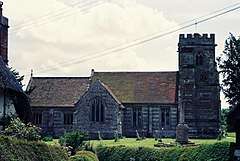 Church of St Mary, St Cuthberga and All Saints |
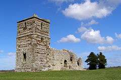
| Ruins of Knowlton Church | Knowlton, Dorset, Woodlands | Parish church | 12th-century origin | 18 March 1955 | SU0238410282 50°53′31″N 1°58′03″W |
1120071 | |
| Woodlands Farm House | Woodlands | Farmhouse | Early 18th century | 18 March 1955 | SU0458808203 50°52′24″N 1°56′10″W |
1303380 | |
.jpg)
gollark: ***__`cargo`__***
gollark: No, *`cargo`* is the way.
gollark: Or - as is traditional for simpler tools - `build.sh`.
gollark: Or use the magic of makefiles!
gollark: Down with C tooling!
Notes
- The date given is the date used by Historic England as significant for the initial building or that of an important part in the structure's description.
- Sometimes known as OSGB36, the grid reference is based on the British national grid reference system used by the Ordnance Survey.
- The "List Entry Number" is a unique number assigned to each listed building and scheduled monument by Historic England.
External links
![]()
This article is issued from Wikipedia. The text is licensed under Creative Commons - Attribution - Sharealike. Additional terms may apply for the media files.