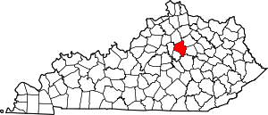
Fairway, Lexington
Fairway is a neighborhood in southeast Lexington, Kentucky, United States. Its boundaries are Sherman Avenue to the north, railroad tracks to the north, Richmond Road to the west, and the Idle Hour Golf Course to the south.[1]
Fairway | |
|---|---|
Neighborhood of Lexington, Kentucky | |
| Coordinates: 38.03°N 84.47°W | |
| Country | United States |
| State | Kentucky |
| County | Fayette |
| City | Lexington |
| Area | |
| • Total | 0.182 sq mi (0.47 km2) |
| • Water | 0.0 sq mi (0.0 km2) |
| Population (2000) | |
| • Total | 677 |
| • Density | 3,725/sq mi (1,438/km2) |
| Time zone | UTC-5 (Eastern (EST)) |
| • Summer (DST) | UTC-4 (EDT) |
| ZIP code | 40502 |
| Area code(s) | 859 |
Neighborhood statistics
- Area: 0.182 square miles (0.47 km2)
- Population: 677
- Population density: 3,725 people per square mile
- Median household income: $67,093 (2010)[1]
gollark: Not really.
gollark: The site compiler knows what it's outputting, but it's a little tricky to map those to actually user-visible "pages".
gollark: That's also hard.
gollark: That is slightly more data than it stores now, and more problematically there isn't actually a list of pages on the site anywhere.
gollark: It's one of the things which would need more intrusive tracking.
This article is issued from Wikipedia. The text is licensed under Creative Commons - Attribution - Sharealike. Additional terms may apply for the media files.


