Autumn Ridge, Lexington
Autumn Ridge is a neighborhood in southeastern Lexington, Kentucky, United States. Its boundaries are I-75 to the east, Barnard Drive to the south, Todds Road to the west, and Vero Court to the north.[1]
Autumn Ridge | |
|---|---|
Neighborhood of Lexington, Kentucky | |
| Country | United States |
| State | Kentucky |
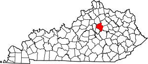
| County | Fayette |
| City | Lexington |
| Area | |
| • Total | .168 sq mi (0.44 km2) |
| • Water | 0.0 sq mi (0.0 km2) |
| Population (2000) | |
| • Total | 645 |
| • Density | 3,850/sq mi (1,490/km2) |
| Time zone | UTC-5 (Eastern (EST)) |
| • Summer (DST) | UTC-4 (EDT) |
| ZIP code | 40509 |
| Area code(s) | 859 |
| Website | autumnridge.org |
Neighborhood statistics
- Area: 0.168 square miles (0.44 km2)
- Population: 645
- Population density: 3,850 people per square mile
- Median household income: $99,526[1]
gollark: Even with root, I've found it really irritatingly hard to do some things with my phone.
gollark: The situation is definitely better than with Apple stuff, but it's still annoying.
gollark: Not *all* of them. I think there's actually an unclaimed bounty on some.
gollark: From them.
gollark: The Android ones.
References
- Autumn Ridge Neighborhood Profile Retrieved 2013-02-23.


This article is issued from Wikipedia. The text is licensed under Creative Commons - Attribution - Sharealike. Additional terms may apply for the media files.