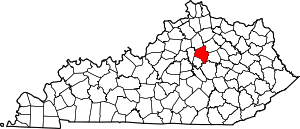
Beaumont Park, Lexington
Beaumont Park is a neighborhood in southwestern Lexington, Kentucky, United States. Its boundaries are Parkers Mill Road to the west, Lane Allen Road to the north, Lansill Dr to the east, and New Circle Road to the south.[1]
Beaumont Park | |
|---|---|
Neighborhood of Lexington, Kentucky | |
| Coordinates: 38.0314°N 84.5602°W | |
| Country | United States |
| State | Kentucky |
| County | Fayette |
| City | Lexington |
| Area | |
| • Total | .194 sq mi (0.50 km2) |
| • Water | 0.0 sq mi (0.0 km2) |
| Population (2000) | |
| • Total | 594 |
| • Density | 3,068/sq mi (1,185/km2) |
| Time zone | UTC-5 (Eastern (EST)) |
| • Summer (DST) | UTC-4 (EDT) |
| ZIP code | 40504 |
| Area code(s) | 859 |
Neighborhood statistics
- Area: 0.194 square miles (0.50 km2)
- Population: 594
- Population density: 3,068 people per square mile
- Median household income (2010): $72,229[1]
Education
gollark: ANdrew pinged all staff.
gollark: Ruby?
gollark: --choose 10000 andrew potatOS heavserver hellboy helloboi EndOS heavdrone rust
gollark: The autobias algorithms weight you differently, yes.
gollark: You should learn this instead: https://github.com/joaomilho/Enterprise
References
- Beaumont Park Neighborhood Profile Retrieved 2013-06-23.
- Elementary School Areas Archived 2011-03-22 at the Wayback Machine Fayette County Public Schools. Retrieved 2013-08-09.
- Middle School Areas Archived 2011-07-19 at the Wayback Machine Fayette County Public Schools. Retrieved 2013-08-09.
- High School Areas Archived 2011-07-19 at the Wayback Machine Fayette County Public Schools. Retrieved 2013-08-09
This article is issued from Wikipedia. The text is licensed under Creative Commons - Attribution - Sharealike. Additional terms may apply for the media files.


