Bryan Station, Lexington, Kentucky
Bryan Station is a neighborhood in Northeast Lexington, Kentucky, United States. It is named after the nearby pioneer settlement by the same name located just 2 miles (3 km) outside the current edge of the city.[1]
Bryan Station | |
|---|---|
Neighborhood of Lexington, Kentucky | |
| Country | United States |
| State | Kentucky |
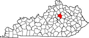
| County | Fayette |
| City | Lexington |
| Area | |
| • Total | 2.013 sq mi (5.2 km2) |
| • Land | 2.013 sq mi (5.2 km2) |
| • Water | 0.0 sq mi (0.0 km2) |
| Population (2000) | |
| • Total | 5,323 |
| • Density | 2,645/sq mi (1,024/km2) |
| Time zone | UTC-5 (Eastern (EST)) |
| • Summer (DST) | UTC-4 (EDT) |
| ZIP code | 40505 |
| Area code(s) | 859 |
The neighborhood's boundaries are New Circle Road to the West, Old Paris Pike to the North, and Preakness Drive and Interstate 75 to the East. An abandoned railroad track between New Circle Road and I-75 separates it from the Eastland neighborhood to the South.[2]
Neighborhood statistics
- Area: 2.013 square miles (5.2 km2)
- Population: 5,323
- Population density: 2,645 people per square mile
- Median household income: $49,678.[2]
gollark: Or `eraseDisk`.
gollark: If you're using camelCase, then `eraseHardDrive`, I guess.
gollark: `erase-hard-drive`
gollark: `readchar`User types `w``'w'` now on stack or whatever.
gollark: IT WOULD READ A KEYPRESS.
See also
References
- Bryan Station - Colonial Kentucky Frontier Retrieved on 2011-01-01
- Bryan Station Neighborhood Profile city-data.com. Retrieved on 2011-01-01


This article is issued from Wikipedia. The text is licensed under Creative Commons - Attribution - Sharealike. Additional terms may apply for the media files.