Calumet, Lexington
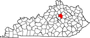
Calumet is a neighborhood in northern Lexington, Kentucky, United States. Its boundaries are Viley Road to the west, Versailles Road to the south, New Circle Road to the north, and Wolf Run Creek to the east.[1]
Calumet | |
|---|---|
Neighborhood of Lexington, Kentucky | |
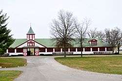 Stables at Calumet Farm | |
| Country | United States |
| State | Kentucky |
| County | Fayette |
| City | Lexington |
| Area | |
| • Total | 0.266 sq mi (0.69 km2) |
| Population (2000) | |
| • Total | 750 |
| • Density | 2,882/sq mi (1,087/km2) |
| Time zone | UTC-5 (Eastern (EST)) |
| • Summer (DST) | UTC-4 (EDT) |
| ZIP code | 40504 |
| Area code(s) | 859 |
Neighborhood statistics
- Area: 0.266 square miles (0.69 km2)
- Population: 750
- Population density: 2,822 people per square mile (1,087/km²)
- Median household income: $49,446[1]
gollark: *Safari* half-implements them, often in broken ways which create more work than not having them would.
gollark: Stuff like IE11 just don't *implement* web standards, which is *okay*, if annoying.
gollark: What?
gollark: Safari tends to have a certain very horrible approach to web standards.
gollark: Also, safar ibad.
References
- Calumet Neighborhood Profile city-data.com. Retrieved on 2011-01-02


This article is issued from Wikipedia. The text is licensed under Creative Commons - Attribution - Sharealike. Additional terms may apply for the media files.