Churchill, Somerset
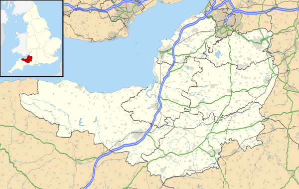
Churchill is a village and civil parish in Somerset, England. It is located in the unitary authority of North Somerset, on the western edge of the Mendip Hills, about 8 miles (12.9 km) east of Weston-super-Mare, and about 15 miles (24.1 km) south-west of Bristol. The parish, which includes the village of Lower Langford and the hamlet of Upper Langford, has a population of 2,250.[1]
| Churchill | |
|---|---|
 Churchill Location within Somerset | |
| Population | 2,250 (2015) |
| OS grid reference | ST455605 |
| Civil parish |
|
| Unitary authority | |
| Ceremonial county | |
| Region | |
| Country | England |
| Sovereign state | United Kingdom |
| Post town | WINSCOMBE |
| Postcode district | BS25 |
| Post town | BRISTOL |
| Postcode district | BS40 |
| Dialling code | 01934 |
| Police | Avon and Somerset |
| Fire | Avon |
| Ambulance | South Western |
| UK Parliament | |
.jpg)
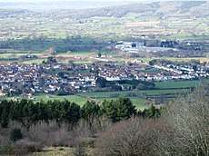
Although relatively close to large urban centres, Churchill has the character of a small country village. The village is settled around the junction of the A38 and A368 and is overlooked by Dolebury Warren, a biological Site of Special Scientific Interest (SSSI), Windmill Hill to the north, and the Mendip Hills, an Area of Outstanding Natural Beauty (AONB), to the south. Churchill, like many villages, grew around its medieval church, and has many listed buildings reflecting the history of the parish.
There is one primary school, a secondary school, a post office, several shops and small businesses, three churches, and four pubs serving the area. There is also a doctor's surgery, allotments at Pudding Pie Lane, a hotel, and a number of bed and breakfast establishments. Recreation facilties include a sports centre with swimming pool, a dry ski slope and an outdoor pursuits. There are active cricket, football and skittles clubs, and many other leisure and sporting activities, including music and walking groups.
History
Toponymy
The origin of the name Churchill is uncertain. The word "cruc" meaning hillock or peak, survives from Anglo-Saxon as "crook" (Crook Peak), "creech" (Evercreech), "critch" (Critchell Farm near Frome). Consequently, one suggestion is that Churchill derived its name from the hillock which is now known as Windmill Hill at Churchill and became Cruc-hill or Cric-hill, often spelt Chirchulle and later distorted to the more familiar Churchill. Attempts to explain its name by reference to the Norman, Roger de Courcelle, the holder of many Manors in Somerset, have been inconclusive and its origin may be nothing more than the proximity of an earlier chapel or church to Windmill Hill.[2]
Pre-history
The village is settled around the junction of the A38 and A368 and is overlooked by Dolebury Warren, a biological Site of Special Scientific Interest (SSSI).[3] Finds from the site demonstrate an extensive period of occupation, and include Palaeolithic flintwork, Bronze Age pottery, a bronze spearhead and Roman coins and pottery.[4] In addition to the remains of double ramparts of an Iron Age hill fort still being visible there is also evidence of a medieval rabbit warren.[5] At Dinghurst south of the village is the site of an Iron Age univallate hill fort and Roman fort.[6][lower-alpha 1]
There is also some archaeological evidence to support Windmill Hill being used in Iron Age and Roman times as a hill fort and look-out point respectively. A prominent feature in the parish, Windmill Hill divides Churchill from Lower Langford, and gained its name from a windmill recorded in Churchill Manor in 1652. There is thought to have been a windmill there as early as the 13th or 14th century when they were first introduced to the region.[8]
Medieval
The present village of Churchill, together with Lower Langford, has its more populous part either on or in close proximity to the A38 road: Churchill Court, the former Manor house, and the Church of St John the Baptist that adjoins it, is isolated on its western edge. Furthermore, Barrow Fields, The Berrys, and Pitchbury, are bare fields in front and beside the church. It has been suggested that the field names are corruptions of the Anglo-Saxon words "burh" or "beorg", meaning townships or mounds of ruined buildings, and that they refer to a medieval settlement now vanished and buried.[9] A large scale map shows a clear pattern of ancient strip fields. Even where later enclosures and the amalgamation of adjoining strips have put hedges around the medieval plots, the lines of these boundaries run at a right-angle to the original strip lynchets and ridge and furrow pattern, both common medieval agricultural practices. In the dry summer of 1996 cropmarks emerged in Barrow Fields, visible from surrounding high ground, showing outlines of dwellings and field boundaries.[10]
There was a settled and developed farming community within Churchill, with the strip fields running out towards the open marshy levels, used for summer grazing, and with drove roads, still existing: Yanel Lane, Sandmead Drove and Common Lane giving access to them. It has been proposed that these droves converged at Churchill Green, the place where cattle, sheep and produce would be conveniently gathered and markets held.[9] Accordingly, there is no clear reason why a village should disappear unless dispossessed by a landlord, anxious to surround his house with a park, or decimated by plague, of which there is no evidence.[lower-alpha 2] It is possible that as wheeled vehicles began to replace the packhorse trains, and traffic grew through the gap in the hills beyond Churchill Gate,[lower-alpha 3] the eastern end of the settlement grew and the houses around the church were deserted.[9][lower-alpha 4]
The Domesday survey did not mention Churchill since it was part of the Manor of Banwell, in the Hundred of Winterstoke, belonging to the Bishop of Bath and Wells and not held in fee direct from the King. Churchill is first mentioned as a separate Manor in 1231 in an award made by Bishop Jocelin of Wells concerning the "chapel of Churchill", and in the same document Robert Fitzpayne,[lower-alpha 5] Sheriff of Somerset under Henry II, and John de la Stocke, are mentioned as local landowners. Stock Lane still carries the name of the 13th century inhabitant and the Fitzpaynes lived at Churchill Court for some two hundred years.[12]
Post-medieval
Sir John Churchill, knighted in 1670, purchased the Manor of Churchill from Richard Jenyns in 1671. He died in 1685, greatly in debt, and Churchill Manor, which he left to his daughter Lady Scroggs, was sold, after complicated litigation, with his other property.[13][lower-alpha 6] The deer park (Churchill Park) enclosed large swathes of land to the north of the main village, with some of the walls still standing around the boundary. There is also evidence of mills and fishponds associated with the manor.[15]
18th and 19th centuries
Broad areas of land were enclosed by the Enclosure Acts in the 18th and 19th centuries.[15] A steep, rocky and untarmacked lane called the Batch was the old Bristol and Exeter coach road, until 1824, when the Commissioners of the Bristol Turnpike Trust determined that they would create a new toll road to avoid the steep incline of the original. A new toll house was built and gate installed across Churchill Gate near Four Cross. The new road, now New Road that constitutes part of the A38, joined the Bristol Turnpike road of Winford and was completed by November 1826.[16] Before that year, the toll road passed in front of the inn called the Nelson Arms in the corner of Skinners Lane and Dinghurst Road, and up to the top of the Batch, coming out into the present road again in Star, a hamlet in the parish of Shipham.[7]
Geography
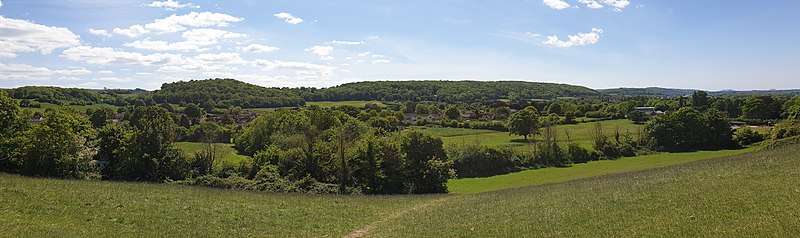
The area is predominantly agricultural, with a high proportion of pasture land. The southern border of the parish lies within the Mendip Hills Area of Outstanding Natural Beauty and rises to a height of about 180 metres (600 feet). This southern area is extensively wooded but also contains large areas of open downland. Much of Churchill parish is low lying moorland to the west and north west where it is less than 15 metres (50 feet) feet above sea level. The lowest part is on the North Somerset Levels where it is only 4.6 metres (15 feet) above sea level.[17]
Further north the land descends into the valley of the Congresbury Yeo river which ultimately drains westward into the Bristol Channel between the coastal towns of Clevedon and Weston-super-Mare. This northern area is sparsely populated and artificially drained, lying almost at sea level, where drainage ditches, or rhynes, replace stone walls and hedges as the field boundaries. The streams, together with the Congresbury Yeo, delineate much of the parish boundary and in the east, the Langford Brook, flowing through Lower Langford, divides that community into two; only the western part being included within Churchill Parish.[18] Windmill hill is 75 metres (246 feet) high and gives good views across the Vale of Wrington, towards the Mendip Hills, the iron age hillfort at Dolebury, the Bristol Channel and Wales to the west and towards the Chew Valley to the east. On Dinghurst Road, the views are dominated by the meadows on Lyncombe Hill and the Mendip Hills.[17]
The land is of the fertile Mercia Mudstone Group, formed of red layers of mudstone and siltstone of Triassic age (see Keuper marl), with peat at the Somerset Levels, giving good pasture on the Mendip Hills. The edge of the hills has carboniferous limestone that has been exposed on the Black Down Pericline due to the erosion of the overlying Triassic dolomitic conglomerate. The dolomitic conglomerate and limestone is used in local buildings and walls. A quarry for conglomerate stone was on the north side of Windmill Hill. Mines in Dolebury Warren have sought lead (galena) with silver, iron (haematite), ochre (limonite), manganese (for glass making) and zinc carbonate (calamine); the latter for brass manufacture.[19] Important features like Dolebury Warren and Burrington Combe were formed by the action of water. Like Cheddar they may be collapsed caves or created by meltwater rushing off the hills during the end of glacial periods.[20]
Governance
From 1894 to 1974 Churchill was part of the Axbridge Rural District.[21] When this was abolished under the Local Government Act 1972 it became part of the Woodspring district in the new county of Avon. In 1996 this became the North Somerset unitary authority, as established by the Local Government Act 1992, which remains part of the ceremonial county of Somerset.[22] The Blagdon and Churchill ward is represented by one councillor on the North Somerset Council.
There are thirteen parish councillors, either elected on a four-yearly basis or co-opted when a vacancy occurs.[1] The parish council has responsibility for local issues, including setting an annual precept (local rate) to cover the council’s operating costs and producing annual accounts for public scrutiny. The parish council evaluates local planning applications and works with the local police, district council officers, and neighbourhood watch groups on matters of crime, security and traffic. The parish council's role also includes initiating projects for the maintenance and repair of parish facilities, such as the memorial hall, playing fields and playgrounds, as well as consulting with the district council on the maintenance, repair and improvement of highways, drainage, footpaths, public transport and street cleaning. Conservation matters (including trees and listed buildings) and environmental issues are also of interest to the council.
The parish is represented in the House of Commons of the Parliament of the United Kingdom as part of the Weston-super-Mare county constituency. The MP for the constituency is John Penrose of the Conservative Party, who first won the seat in the 2005 General Election.
Population
After World War II new houses were built around the crossroads and towards Lower Langford.[23] The parish contains two substantial population groupings, Churchill and Lower Langford, and their centres are separated by about a mile. However, beginning in the late 1980s, development of an area lying between these centres has added some 200 new homes, and this development has served substantially to unite the two centres.[18] Nevertheless, Churchill is still an important agricultural area and retains its rural appeal. Consequently, it has now developed into both a retirement area and a dormitory for people working in Weston-super-Mare and Bristol.[23]
Transport
_-_Flickr_-_secret_coach_park.jpg)
The village is not well-served by buses, but services are available to Weston-Super-Mare, Bristol, Wells, Cheddar, Shipham, and a limited number of other destinations.[1] A Stagecoach bus, known as the "South West Falcon", connects Devon with Somerset, Bristol Airport and Bristol, and can be boarded from a number of bus stops in the parish.[24]
Three heavily trafficked major roads traverse the parish: the A38, the A368 and the B313. Congestion results from the lack of an adequate east-west road link immediately south of Bristol.[18] However, Churchill's proximity to Bristol Airport and Yatton Railway Station, and to the M5 Motorway, junction 21 is 7 miles (11 kilometres), and junction 22 is 10 miles (16 kilometres), make it a good location for people whose work takes them about the country. The second Severn Crossing adds to mobility and the M4 is 20 miles (32 kilometres) away.[23]
Education
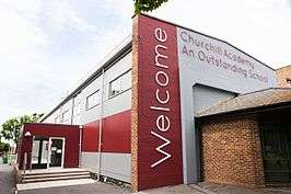
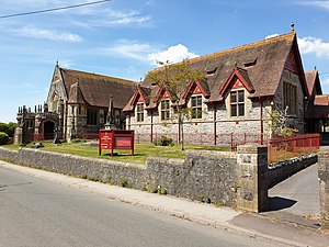
There are two schools within the parish: a Church of England Voluntary Controlled (CEVC) primary school, serving both Churchill and Langford, and Churchill Academy and Sixth Form, a large state-run secondary school and specialist Arts College, serving nearby villages in North Somerset.[18]
Churchill Primary School has around 200 pupils aged 4 to 11 years and is located in the adjacent village of Lower Langford. It was newly built in 2002 after relocating from its former location at Ladymead Lane. Churchill Academy, built in the 1960s, has around 1,550 students between the ages of 11 and 18 years and is located on Churchill Green. Facilities include the sixth form centre, cafeterias and the neighbouring Churchill Sports Centre with playing fields.[18]
Langford House, built in the middle of the 19th century, has more recently become home to the Veterinary School of the University of Bristol, with around 650 undergraduate and postgraduate students and 300 staff. About half of the veterinary students live on site, or in surrounding villages, and others reside in Bristol.[25]
Religious sites
The church of St John the Baptist was built around 1360 and restored in 1879. The tower has three stages with diagonal buttresses, moulded string courses, north-east polygonal higher corner stair turret with blind panelled embattled cap and pierced quatrefoil lozenge parapet with corner pinnacles and gargoyles.[26]
There is also a Methodist Church that was built in 1880 by Sidney Hill, a local businessman and benefactor, as a memorial to his wife, and both are interred in a mausoleum along the front of the building.[27][lower-alpha 7]
Buildings and monuments of interest
There are many listed buildings and monuments reflecting the history and diverse architecture of the village:[29]
| Name | Location | Type | Completed [note 1] | Grid ref.[note 2] Geo-coordinates | Notes | Entry number [note 3] | Image | Ref. |
|---|---|---|---|---|---|---|---|---|
| Over Langford Manor | Upper Langford | Old Courthouse | 15th century | ST4584059522 51°19′56″N 2°46′44″W |
Also known as The Old Courthouse of the infamous Judge Jeffreys | 1311746 | [30] | |
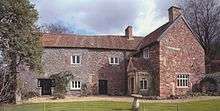
| Churchill Court | Churchill | Manor house | 16th century | ST4368560191 51°20′17″N 2°48′35″W |
Former Manor house adjoining St John’s Church, the oldest dwelling site in the village | 1320945 |  | [31] |
| April Cottage | Churchill | House | Mid-16th century | ST4403459932 51°20′09″N 2°48′17″W |
Located on Front Street | 1129234 | | [32] |
| Ash Green | Churchill | Detached House | 17th century core with left-hand early 19th century wing | ST4418059877 51°20′07″N 2°48′10″W |
Located on Front Street | 1320946 | | [33] |
| Mountain Ash Cottage | Churchill | Semi-detached House | 18th century with early 19th century alterations | ST4424159777 51°20′04″N 2°48′06″W |
Located on Front Street | 1157936 | | [34] |
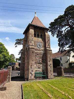
| Jubilee Clock Tower | Churchill | Clock Tower | 1897 with 1977 restoration | ST4441559719 51°20′02″N 2°47′57″W |
Built to commemorate Queen Victoria's Diamond Jubilee of 1897. It was built by Foster and Wood of Bristol and was restored in 1977. It was erected at the expense of Sidney Hill | 1157918 | [35][28] | |
| Telephone Kiosk | Churchill | K6 Telephone Kiosk | 1935 | ST4400859927 51°20′08″N 2°48′18″W |
The Churchill Parish Council bought the red telephone kiosk in Front Street in 2017 after it was decommissioned by BT. Designed by Sir Giles Gilbert Scott in 1935, and of Type K6 design, the Parish Council purchased the kiosk because of "its heritage appearance in the locality" | 1129230 | 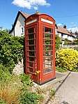 Telephone Kiosk | [36] |
Notes
- The date given is the date used by Historic England as significant for the initial building or that of an important part in the structure's description.
- Sometimes known as OSGB36, the grid reference is based on the British national grid reference system used by the Ordnance Survey.
- The "List Entry Number" is a unique number assigned to each listed building and scheduled monument by Historic England.
Sport and recreation
Churchill has a sports centre with swimming pool, a dry ski slope and an outdoor pursuits centre and four pubs: The Crown Inn, The Nelson Arms, The Stag and Hounds and The Churchill Inn. There are active cricket, football and skittles clubs, and many other leisure and sporting activities, including music and walking groups.[1]
Other facilities
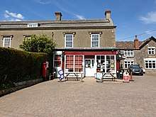
The village has a post office with shop and tea rooms, a fish and chip shop, a memorial hall,[lower-alpha 8] a doctor's surgery, allotments at Pudding Pie Lane, a hotel, and a number of bed and breakfast establishments.
Notable people

- Jenny Jones, Britain's Olympic snowboarding medalist trained on the dry ski slope at the Mendip Activity Centre. She was the first Briton ever to win an Olympic medal for a snow event.[38]
- Stefanie Martini, television actor, who has starred in shows Doctor Thorne (2016), Emerald City (2017) and Prime Suspect 1973.[39]
- Ruby Harrold - Olympic gymnast.[40]
In popular culture
On 18 November 1940, American magazine Life published a major feature on the village and its residents. It was intended as an American wartime propaganda exercise to show the world "the secret of British courage under the German bombs" and sought to gain American support for the British war effort.[7] Included were many photographs taken by Cecil Beaton.[41] In December 1940, Pathé News followed-up the article with a short film on village life in Churchill.[42]
During the fifth episode of series three of Top Gear, Jeremy Clarkson crashed a Toyota Hilux into an oak tree in the car park of St John the Baptist Church. The churchwarden had presumed that the damage had been accidental until the Top Gear episode was broadcast. After the BBC was contacted, the director of Top Gear admitted guilt and the broadcaster paid compensation.[43]
References
- "Churchill Area". Churchill Parish Council. 24 June 2015. Archived from the original on 7 May 2020. Retrieved 7 May 2020.
- Bailey & Neale 1977, p. 23; North Somerset Council 2019, p. 4.
- "Natural England citation sheet for Dolebury Warren" (PDF). Natural England. 1983. Archived (PDF) from the original on 8 May 2020. Retrieved 7 May 2020.
- Historic England. "Dolebury Camp: a large univallate hillfort and associated and later earthworks on Dolebury Warren (1008184)". National Heritage List for England. Retrieved 7 May 2020.
- "Dolebury Warren". Avon Wildlife Trust. 2020. Archived from the original on 8 May 2020. Retrieved 7 May 2020.
The site of an Iron Age hill fort, now a haven for wildflowers and butterflies.
- "Dinghurst Camp". Pastscape. Historic England. 2004. Monument Number 194536. Archived from the original on 7 May 2020. Retrieved 7 May 2020.
- North Somerset Council 2019, p. 5.
- Hodges 1996, p. 3; North Somerset Council 2019, pp. 5,12.
- Bailey & Neale 1977, p. 24.
- Bailey & Neale 1977, p. 24; North Somerset Council 2019, p. 5.
- Knight 1915, p. 191; Collinson 1791, p. 33, Vol. 1, Introduction. Sheriffs of this County.
- Knight 1915, p. 191.
- Master 1898, p. 21.
- Bailey & Neale 1977, pp. 23, 29.
- North Somerset Council 2019, p. 12.
- "First Notice that the Commissioners of the Bristol Turnpikes will cut a new road through Churchill to bypass Churchill Batch". Bristol Mirror. 10 July 1824. p. 3. Retrieved 15 May 2020. "Letter to the Editor discussing a new road to join the newly cut road at Rowberrow". Bristol Mirror. 25 November 1826. p. 4. Retrieved 15 May 2020.
- North Somerset Council 2019, p. 7; Hodges 1996, p. 3.
- Bush 2008, p. 5.
- Gough 1967, pp. 2–5; Hodges 1996, p. 3.
- Hodges 1996, p. 3.
- "Axbridge RD through time. Census tables with data for the Local Government District". A vision of Britain Through Time. University of Portsmouth. 2020. Archived from the original on 28 September 2018. Retrieved 7 May 2020.
- "The Avon (Structural Change) Order 1995". legislation.gov.uk. The National Archives. 1995. Archived from the original on 23 August 2019. Retrieved 7 May 2020.
- Hodges 1996, p. 53.
- "Stagecoach celebrates South West Falcon carrying 150000 passenger". www.stagecoachbus.com. Stagecoach. 9 January 2017. Archived from the original on 10 May 2020. Retrieved 10 May 2020.
- Bush 2008, pp. 5–6.
- Historic England. "Church of St John the Baptist, Churchill (1157891)". National Heritage List for England. Retrieved 7 May 2020.
- "Our story". Churchill Methodist Church. 2020. Archived from the original on 10 May 2020. Retrieved 10 May 2020.
- Hodges 1996, p. 39.
- North Somerset Council 2019, p. 10.
- Historic England. "The Old Courthouse (1311746)". National Heritage List for England. Retrieved 7 May 2020.
- Historic England. "Churchill Court (1320945)". National Heritage List for England. Retrieved 3 May 2020.
- Historic England. "April Cottage (1129234)". National Heritage List for England. Retrieved 3 May 2020.
- Historic England. "Ash Green (1320946)". National Heritage List for England. Retrieved 3 May 2020.
- Historic England. "Mountain Ash Cottage (1157936)". National Heritage List for England. Retrieved 3 May 2020.
- Historic England. "Jubilee Clock Tower and attached Walls and Railing (1129198)". National Heritage List for England. Retrieved 7 May 2020.
- Historic England. "K6 Telephone Kiosk (1129230)". National Heritage List for England. Retrieved 11 May 2020. "Parish council buys phone box". Weston Mercury. 11 March 2017. Archived from the original on 11 May 2020. Retrieved 11 May 2020.
- "Churchill's Hall. Memorial Opened in Crowded Presence". Western Daily Press. 12 November 1925. p. 11. OCLC 751668290. Retrieved 11 May 2020.
- "Jenny Jones: Olympic victory tour through Bristol streets". BBC News Online. 3 March 2014. Archived from the original on 23 July 2014. Retrieved 11 May 2020.
- Frost, Sam (18 September 2018). "Top students recognised at school awards ceremony". Weston Mercury. Archived from the original on 18 September 2018. Retrieved 8 May 2020.
- Frost, Sam (6 February 2017). "Marking 60 years of Churchill Academy". Weston Mercury. Archived from the original on 11 May 2017. Retrieved 10 May 2020.
- Life 1940, pp. 87–95, Vol. 9, Iss. 21.
- Pathé, British (26 December 1940). "Churchill Village". www.britishpathe.com. 1298.18. Retrieved 9 May 2020.
- "BBC stumps up for tree stunt". BBC News Online. 21 February 2004. Archived from the original on 2 July 2018. Retrieved 11 May 2020.
Footnotes
- The settlement of Dinghurst, also known as Churchill Batch, is in the south-westerly quarter of the present-day Churchill village. It became part of Churchill parish in 1935.[7]
- Nevertheless, some authors surmise that there are plague pits at Barrow Fields.[7]
- See the construction of the turnpike in the 18th and 19th Centuries section.
- The houses would be little more than huts.[9]
- References and source documents spell his name variously as Fitzpayne, Fitzpain, and Fitzpaine.[11]
- Sir John Churchill bought Churchill Court in order to acquire an estate bearing his name; so despite the connection with the Churchill family, the village did not give its name to them or derive it from theirs.[14]
- Sidney Hill made his fortune in South Africa after giving up his intended journey to New Zealand. He was in Port Elizabeth in 1857 to 1864 and again in August 1865 to 1874, he went there again after the death of his wife but returned finally in 1877 when he bought Langford House and estate, now the University of Bristol School of Veterinary Science.[28]
- Opened on 11 November 1925.[37]
Bibliography
- Bailey, J.; Neale, F. A. (1977). Langley, Peter (ed.). Langford and Churchill Guide. Sir John Wills. Churchill: Cliftonprint. OCLC 852053375.
- Bush, Jackie (2008). "Parish Plan" (PDF). Churchill Parish Council. Archived (PDF) from the original on 8 June 2020. Retrieved 8 June 2020.
- Collinson, Rev. John (1791). History and Antiquities of the County of Somerset. Bath: R. Cruttwell. OCLC 847940764. Retrieved 11 May 2020.
- Gough, John Wiedhofft (1967). The mines of Mendip. Newton Abbot: David & Charles. OCLC 3087178.
- Hodges, Michael A. (1996). Churchill: A Brief History of the area of the Civil Parish (Revised 13 September 1996 ed.). Wrington: West Country Design. OCLC 31076058.
- Knight, Francis Arnold (1915). "Churchill". The heart of Mendip. London: Dent. OCLC 56003550.
An account of the history, archaeology and natural history of the parishes of Winscombe, Shipham, Rowberrow.
- Master, Rev. George Streynsham (1898). Collections for a parochial history of Backwell. Somerset Archaeological and Natural History Society. Backwell: Lavars & Co. OCLC 81066198. Retrieved 11 May 2020.
- North Somerset Council (2019). Conservation Area Appraisal And Management Plan (PDF) (Report). Churchill. Archived (PDF) from the original on 15 May 2020. Retrieved 15 May 2020.
- "Churchill, England 'What we fight for'". Life. Time Inc. 9 (21): 87–95. 18 November 1940. ISSN 0024-3019. OCLC 440821060. Retrieved 7 May 2020.
Further reading
- Butler, W. F. (2002). Churchill names and places. Bristol: University of Bristol. OCLC 852169139.
External links
| Wikimedia Commons has media related to Churchill, Somerset. |
| East of England | 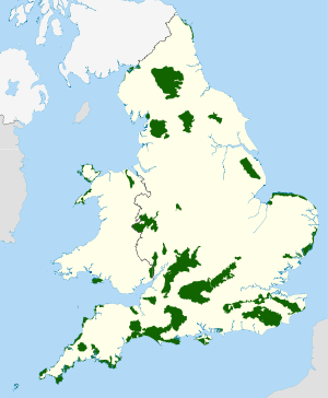 | |
|---|---|---|
| East Midlands | ||
| North East | ||
| North West | ||
| South East |
| |
| South West |
| |
| West Midlands | ||
| Yorkshire and Humber | ||
| ||
| Authority control |
|---|