Astor Place station
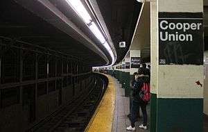
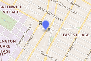
Astor Place, also called Astor Place – Cooper Union on signs, is a local station on the IRT Lexington Avenue Line of the New York City Subway. Completed in 1904, it is one of the original twenty-eight stations in the system. Located at the intersection of Lafayette Street, Eighth Street, Fourth Avenue, Cooper Square, and Astor Place between the East Village and NoHo, it is served by the 6 train at all times, the <6> train during weekdays in the peak direction, and by the 4 train during late nights. The station is on the National Register of Historic Places.
Astor Place | |||||||||||
|---|---|---|---|---|---|---|---|---|---|---|---|
 Downtown platform | |||||||||||
| Station statistics | |||||||||||
| Address | Astor Place & Lafayette Street New York, NY 10003 | ||||||||||
| Borough | Manhattan | ||||||||||
| Locale | NoHo / East Village | ||||||||||
| Coordinates | 40°43′47″N 73°59′30″W | ||||||||||
| Division | A (IRT) | ||||||||||
| Line | IRT Lexington Avenue Line | ||||||||||
| Services | 4 6 | ||||||||||
| Transit connections | |||||||||||
| Structure | Underground | ||||||||||
| Platforms | 2 side platforms | ||||||||||
| Tracks | 4 | ||||||||||
| Other information | |||||||||||
| Opened | October 27, 1904[1] | ||||||||||
| Station code | 407[2] | ||||||||||
| Accessible | |||||||||||
| Wireless service | |||||||||||
| Opposite-direction transfer available | No | ||||||||||
| Former/other names | Astor Place – Cooper Union Cooper Union | ||||||||||
| Traffic | |||||||||||
| Passengers (2019) | 5,502,925[4] | ||||||||||
| Rank | 81 out of 424[4] | ||||||||||
| Station succession | |||||||||||
| Next north | 14th Street – Union Square: 4 | ||||||||||
| Next south | Bleecker Street: 4 | ||||||||||
| |||||||||||
| |||||||||||
| |||||||||||
Astor Place Subway Station (IRT) | |||||||||||
New York City Landmark No. 1096 | |||||||||||
| MPS | New York City Subway System MPS | ||||||||||
| NRHP reference No. | 04001013[5] | ||||||||||
| NYCL No. | 1096 | ||||||||||
| Significant dates | |||||||||||
| Added to NRHP | September 17, 2004 | ||||||||||
| Designated NYCL | November 24, 1981[6] | ||||||||||

History
Construction started on the first IRT line in 1900.[7] The part of the line from City Hall to just south of 42nd Street was part of the original IRT line including the Astor Place station, opened on October 27, 1904.[1]
In 1981, the MTA listed the station among the 69 most deteriorated stations in the subway system.[8] The station underwent renovation from June 1984 to May 1986. The station was renovated for $2.5 million, and was part of the Adopt-a-Station program. The money included $600,000 from the Federal Urban Mass Transit Administration, $125,000 from private sources, including some from the Vincent Astor Foundation. The scope of the project included the restoration of the famous glazed ceramic beaver plaques, new improved lighting, the installation of noise-abatement material, as well as the installation of new brown floor tiles. A new piece of porcelain steel artwork by Cooper Union alumnus Milton Glaser was installed, and a cast-iron copy of one of the station's original kiosks was built. There was an underpass between the uptown and downtown sides, but it was closed and covered up in the 1980s renovation.[9]
The original plans for the Hudson and Manhattan Railroad (now PATH) included a spur along Ninth Street to this station.[10]
Station layout
| G | Street level | Entrances/exits |
| P Platform level |
Side platform | |
| Northbound local | ← ← | |
| Northbound express | ← | |
| Southbound express | | |
| Southbound local | | |
| Side platform | ||
Astor Place is a local station with four tracks and two side platforms. The fare control is at platform level, and the underpass connecting northbound and southbound sides was removed in the 1980s. The access hatch to the underpass is visible behind the northbound token booth inside the fare control area. The northbound platform contains a news and candy stand, which replaced the original public women's lavatory. On the southbound side, the station has a department store entrance into a K-Mart. This store was originally constructed in 1868 as an A. T. Stewart. It had changed ownership and was a Wanamaker's when the station was constructed. The heavy brick-faced square columns on the downtown platform support the store above. The northern building of Wanamaker's store, but not the southern building above, burned in the 1950s. Octagonal windows on the brick wall of the platform were the store's showcases.
Plaques of beavers are located on the walls, in honor of John Jacob Astor's fortune derived from the beaver-pelt trade. The plaques, as well as name tablets, were made by the Grueby Faience Company in 1904. During the renovation, the magnificent maroon and gold tile Cooper Union signs underneath the tile Astor Place signs were destroyed.[11] Black and white pillar signs read Astor Place on one pillar, then Cooper Union on the next.
Exits
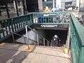
The station has two entrances, one in each direction. The southbound platform's entrance is at the southwest corner of Astor Place and Lafayette Street, while the northbound platform's entrance is in the traffic island bounded by Fourth Avenue, Lafayette Street, and Eighth Street.[12] There is a reproduction of an IRT entry kiosk on the street level over the northbound entrance.
Points of interest
The station itself is a point of local interest, as it is on the List of Registered Historic Places in New York. Several other sites of historical and cultural importance are located near the station. The New York University and Cooper Union are both located nearby. Visitors to the Astor Place area often rotate the Alamo Cube, at street level above the tail end of the northbound platform.[13] A tiled-up doorway, on southwest wall behind the southbound token booth, sports a lintel proclaiming "Clinton Hall". This doorway once led to the New York Mercantile Library in the former Astor Opera House.[14] Other points of interest include:
- McSorley's Old Ale House[13]
- Cooper Union New Academic Building[13]
- Cooper Square Hotel[13]
- Public Theater (Astor Library)[13]
- Colonnade Row / Astor Place Theatre (Blue Man Group)[13]
- Kmart (former Wanamaker Department Store Annex)[13]
- Hamilton Fish House[13]
The Eighth Street – New York University station on the BMT Broadway Line is one block west of the station.[13]
In popular culture
The cover image of Billy Joel's 1976 album Turnstiles was shot on the uptown side of the station.[15]
Image gallery
 Downtown entrance
 Uptown entrance, a reproduction of an old IRT kiosk
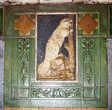 Faience plaque with beaver, by Heins & LaFarge / Grueby Faience Company, 1904. The Astor fortune was based on trading beaver pelts
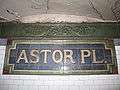 Faience name tablet by Heins & LaFarge / Grueby Faience Company, 1904
 Tile with initial "A"
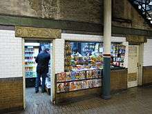 Former women's restroom converted into newsstand
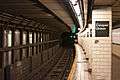 Columns with alternating Astor Place and Cooper Union sign plates
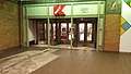 Entrance to Kmart on the southbound platform
References
- "Our Subway Open: 150,000 Try It; Mayor McClellan Runs the First Official Train". The New York Times. October 28, 1904. p. 1. ISSN 0362-4331. Retrieved April 21, 2020.
- "Station Developers' Information". Metropolitan Transportation Authority. Retrieved June 13, 2017.
- "NYC Subway Wireless – Active Stations". Transit Wireless Wifi. Retrieved November 13, 2019.
- "Facts and Figures: Annual Subway Ridership 2014–2019". Metropolitan Transportation Authority. 2020. Retrieved May 26, 2020.
- "NPS Focus". National Register of Historic Places. National Park Service. Retrieved December 9, 2011.
- "Interborough Rapid Transit System, Underground Interior" (PDF). New York City Landmarks Preservation Commission. November 24, 1981. Retrieved November 19, 2019.
- "Rapid Transit Tunnel Begun - Ground Officially Broken (1900)". www.nycsubway.org.
- Gargan, Edward A. (June 11, 1981). "Agency Lists Its 69 Most Deteriorated Subway Stations". The New York Times. Retrieved August 13, 2016.
- Blau, Eleanor (May 17, 1986). "Refurbishing of IRT Station Applauded by Well-Wishers". The New York Times. ISSN 0362-4331. Retrieved September 5, 2016.
- "Map of Hudson & Manhattan Railroad Hudson Tunnel System" (PDF). columbia.edu. Hudson & Manhattan Railroad. December 31, 1912. Retrieved September 5, 2016.
- "1982 Photo of Astor Place Signage". Cable (Cooper Union Yearbook). 1982. Retrieved December 9, 2009.
- "MTA Neighborhood Maps: East Village" (PDF). mta.info. Metropolitan Transportation Authority. 2015. Retrieved August 19, 2015.
- "MTA Neighborhood Maps: East Village" (PDF). mta.info. Metropolitan Transportation Authority. 2015. Retrieved September 5, 2015.
- "Clinton Hall at Astor Place". Forgotten New York.
- Katz, Mike, 1962-. Rock and roll explorer guide to New York City. Kott, Crispin,, McNeil, Legs,. Guilford, Connecticut. p. 150. ISBN 978-1-63076-316-9. OCLC 1007036799.CS1 maint: extra punctuation (link) CS1 maint: multiple names: authors list (link)
Further reading
- Stookey, Lee (1994). Subway ceramics : a history and iconography of mosaic and bas relief signs and plaques in the New York City subway system. Brattleboro, Vt: L. Stookey. ISBN 978-0-9635486-1-0. OCLC 31901471.
External links
| Wikimedia Commons has media related to Astor Place (IRT Lexington Avenue Line). |
- nycsubway.org – IRT East Side Line: Astor Place
- nycsubway.org — Untitled Artwork by Milton Glaser (1986)
- Station Reporter — 6 Train
- Forgotten NY: Subways and Trains — Original 28 IRT subway stations
- MTA's Arts For Transit — Astor Place (IRT Lexington Avenue Line)
- Fourth Avenue entrance from Google Maps Street View
- Lafayette Street entrance from Google Maps Street View
- Platforms from Google Maps Street View
- Lobby and Kmart entrance from Google Maps Street View
| Lexington Ave. Line |
|
|---|---|
| |
| Topics |  | |
|---|---|---|
| Lists by county |
| |
| Lists by city | ||
| Other lists | ||
| ||