National Register of Historic Places listings in Schoharie County, New York
List of the National Register of Historic Places listings in Schoharie County, New York
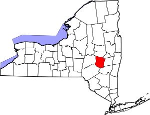
Location of Schoharie County in New York
This is intended to be a complete list of properties and districts listed on the National Register of Historic Places in Schoharie County, New York. The locations of National Register properties and districts (at least for all showing latitude and longitude coordinates below) may be seen in a map by clicking on "Map of all coordinates".[1]
- This National Park Service list is complete through NPS recent listings posted August 14, 2020.[2]
| Albany (Albany) – Allegany – Bronx – Broome – Cattaraugus – Cayuga – Chautauqua – Chemung – Chenango – Clinton – Columbia – Cortland – Delaware – Dutchess (Poughkeepsie, Rhinebeck) – Erie (Buffalo) – Essex – Franklin – Fulton – Genesee – Greene – Hamilton – Herkimer – Jefferson – Kings – Lewis – Livingston – Madison – Monroe (Rochester) – Montgomery – Nassau – New York (Below 14th Street, 14th to 59th Streets, 59th to 110th Streets, Above 110th Street, Islands) – Niagara – Oneida – Onondaga – Ontario – Orange – Orleans – Oswego – Otsego – Putnam – Queens – Rensselaer – Richmond – Rockland – St. Lawrence – Saratoga – Schenectady – Schoharie – Schuyler – Seneca – Steuben – Suffolk – Sullivan – Tioga – Tompkins – Ulster – Warren – Washington – Wayne – Westchester (Northern, Southern, New Rochelle, Peekskill, Yonkers) – Wyoming – Yates |
Listings county-wide
| [3] | Name on the Register | Image | Date listed[4] | Location | City or town | Description |
|---|---|---|---|---|---|---|
| 1 | American Hotel | 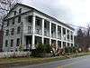 American Hotel |
September 9, 1975 (#75001228) |
Main St. 42°47′37″N 74°37′03″W |
Sharon Springs | |
| 2 | Becker Stone House | 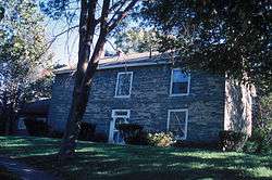 Becker Stone House |
November 20, 1979 (#79001630) |
East of Schoharie on Murphy Rd. 42°40′22″N 74°15′08″W |
Schoharie | |
| 3 | Becker–Westfall House | November 20, 1979 (#79001631) |
East of Schoharie on NY 443 42°40′33″N 74°15′13″W |
Schoharie | ||
| 4 | Bellinger–Dutton House | 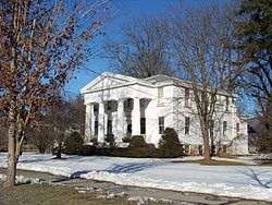 Bellinger–Dutton House |
December 7, 2005 (#05001380) |
158 River St. (NY 30) 42°36′15″N 74°20′13″W |
Middleburgh | |
| 5 | Dr. Christopher S. Best House and Office | 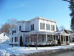 Dr. Christopher S. Best House and Office |
August 15, 2001 (#01000849) |
34 Clauverwie St. 42°35′47″N 74°19′59″W |
Middleburgh | |
| 6 | Marshall D. Bice House | June 12, 2017 (#100001072) |
229 Main St. 42°39′40″N 74°18′58″W |
Schoharie | Elaborate 1868 brick Italianate house built by local developer | |
| 7 | Bramanville Mill | 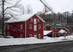 Bramanville Mill |
August 27, 1976 (#76001276) |
East of Cobleskill on Caverns Rd. 42°41′17″N 74°24′22″W |
Cobleskill | |
| 8 | Breakabeen Historic District |  Breakabeen Historic District |
December 31, 1974 (#74001304) |
Roughly bounded by River St., new Route 30, and Main St. to Bush Rd. 42°31′27″N 74°23′07″W |
Breakabeen | |
| 9 | Bunn–Tillapaugh Feed Mill | September 29, 2006 (#06000894) |
2 High St. 42°37′59″N 74°33′50″W |
Richmondville | ||
| 10 | Bute–Warner–Truax Farm |  Bute–Warner–Truax Farm |
July 25, 1985 (#85001611) |
Truax Rd. 42°34′22″N 74°39′29″W |
Charlotteville | |
| 11 | Cobleskill Historic District | 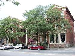 Cobleskill Historic District |
September 18, 1978 (#78001910) |
Irregular pattern along Washington Ave., Main, Grand, and Elm Sts. 42°40′41″N 74°29′03″W |
Cobleskill | |
| 12 | The Colyer House | February 13, 2008 (#08000025) |
5729 NY 30 42°41′43″N 74°17′51″W |
Schoharie | ||
| 13 | First Presbyterian Church of Jefferson | August 7, 2012 (#12000481) |
Creamery St. at Park Ave. 42°28′50″N 74°36′48″W |
Jefferson | Now a museum | |
| 14 | Forks in the Road Schoolhouse | July 6, 2005 (#05000665) |
115 Lumber Rd. 42°24′43″N 74°33′48″W |
South Gilboa | ||
| 15 | Gallupville Evangelical Lutheran Church | 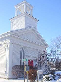 Gallupville Evangelical Lutheran Church |
December 31, 2002 (#02001652) |
980 NY 443 42°39′48″N 74°14′04″W |
Gallupville | |
| 16 | Gallupville House | 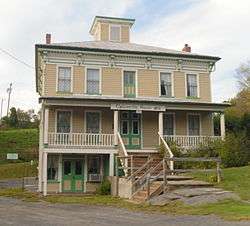 Gallupville House |
September 7, 1979 (#79001629) |
Main St. 42°39′46″N 74°13′58″W |
Gallupville | |
| 17 | Gallupville Methodist Church | 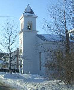 Gallupville Methodist Church |
May 30, 2001 (#01000584) |
Factory St. 42°39′45″N 74°14′03″W |
Gallupville | |
| 18 | Christian Hess House and Shoemaker's Shop | June 30, 2015 (#15000369) |
111 Stony Brook Rd. 42°38′40″N 74°19′12″W |
Schoharie | ||
| 19 | Peter A. Hilton House | September 24, 2004 (#04001063) |
6605 NY 10 42°44′30″N 74°35′24″W |
Beekman Corners | ||
| 20 | House at 461 Spruce Lake Road | January 7, 2015 (#14001130) |
461 Spruce Lake Road 42°35′04″N 74°35′58″W |
Summit | A rare remaining stacked plank house from the mid-19th century. | |
| 21 | Daniel Webster Jenkins House | May 4, 2018 (#100002387) |
207 Church Street 42°42′38″N 74°20′19″W |
Central Bridge | 1884 Queen Anne house built by prominent local citizen who served as local railroad stationmaster | |
| 22 | Lansing Manor House | 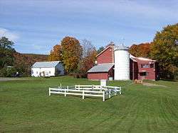 Lansing Manor House |
May 25, 1973 (#73001268) |
2 miles (3.2 km) south of North Blenheim on NY 30 42°27′04″N 74°27′54″W |
Blenheim | |
| 23 | Lasell Hall | 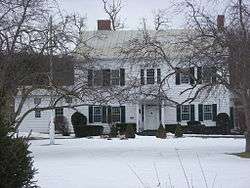 Lasell Hall |
January 11, 2002 (#01001444) |
350 Main St. 42°39′45″N 74°18′45″W |
Schoharie | |
| 24 | Johannes Lawyer Jr. House | February 23, 2016 (#16000039) |
194 Main St. 42°39′27″N 74°18′52″W |
Schoharie | 1790 house dates to post-Revolutionary rebuilding of village, uses a variety of architectural styles | |
| 25 | John Lehman House | January 4, 2012 (#11001008) |
407 Kilts Rd. 42°47′32″N 74°34′59″W |
Sharon | ||
| 26 | Livingstonville Community Church | 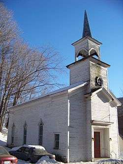 Livingstonville Community Church |
January 9, 2008 (#07001370) |
1667 Hauverville Rd. 42°29′24″N 74°16′06″W |
Livingstonville | |
| 27 | Jacob T. Miers House | December 1, 2015 (#15000857) |
103 Knower Ave. 42°39′43″N 74°19′04″W |
Schoharie | 1871 Second Empire house that has been home to village library for a half-century | |
| 28 | North Blenheim Historic District | 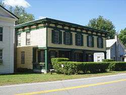 North Blenheim Historic District |
December 31, 1974 (#74001303) |
Both sides of NY 30, beside Schoharie Creek 42°28′13″N 74°27′03″W |
Blenheim | |
| 29 | Old Blenheim Bridge | Old Blenheim Bridge |
October 15, 1966 (#66000570) |
NY 30 over Schoharie Creek 42°28′21″N 74°26′29″W |
North Blenheim | Destroyed August 28, 2011 in flooding caused by Hurricane Irene[5] |
| 30 | Old Lutheran Parsonage | .jpg) Old Lutheran Parsonage |
June 19, 1972 (#72000913) |
Adjacent to Spring St. in Lutheran Cemetery 42°39′42″N 74°18′31″W |
Schoharie | |
| 31 | Old Stone Fort | 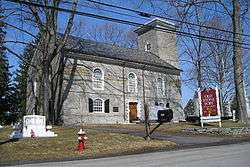 Old Stone Fort |
December 31, 2002 (#02001643) |
145 Fort Rd. 42°40′38″N 74°18′08″W |
Schoharie | |
| 32 | Parker 13-Sided Barn | 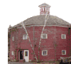 Parker 13-Sided Barn |
September 29, 1984 (#84002967) |
NY 10 42°28′51″N 74°36′17″W |
Jefferson | part of the Central Plan Dairy Barns of New York Thematic Resource (TR) |
| 33 | Richmondville United Methodist Church | 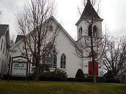 Richmondville United Methodist Church |
July 14, 2006 (#06000575) |
266 Main St. 42°37′57″N 74°33′56″W |
Richmondville | |
| 34 | Schoharie County Courthouse Complex | 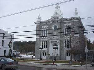 Schoharie County Courthouse Complex |
August 15, 1995 (#95001010) |
Main St. 42°39′49″N 74°18′44″W |
Schoharie | |
| 35 | Schoharie Valley Railroad Complex | 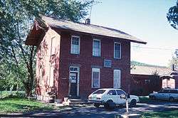 Schoharie Valley Railroad Complex |
April 26, 1972 (#72000914) |
Depot Lane 42°40′13″N 74°18′39″W |
Schoharie | |
| 36 | Schoharie Village Historic District | April 5, 2019 (#100003624) |
Portions of Main, Bridge, Fair, Grand, Orchard & Prospect Sts., Fort Rd., Academy, Furman & Sunset Drs., Birchez, Depot, Estenes, Mix & Quilt Lns., Johnson, Knower & Shannon Aves. 42°39′49″N 74°18′45″W |
Schoharie | Core of village first settled by Palatine Germans in 1710s | |
| 37 | Shafer Site | November 28, 1980 (#80002764) |
Address Restricted |
Fulton | ||
| 38 | Sharon Springs Historic District | 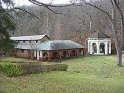 Sharon Springs Historic District |
June 3, 1994 (#94000541) |
Junction of NY 10 and US 20 42°47′32″N 74°36′56″W |
Sharon Springs | |
| 39 | South Gilboa Railroad Station | February 25, 2000 (#00000090) |
Bailey Spur Rd. 42°24′36″N 74°33′30″W |
South Gilboa | ||
| 40 | St. John's Lutheran Church | September 12, 2008 (#08000864) |
6569 NY 10 42°44′28″N 74°35′08″W |
Beekman Corners | ||
| 41 | St. Mark's Evangelical Lutheran Church | 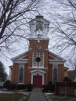 St. Mark's Evangelical Lutheran Church |
July 14, 2006 (#06000572) |
326 Main St. 42°35′56″N 74°20′07″W |
Middleburgh | |
| 42 | St. Paul's Lutheran Church Historic District | 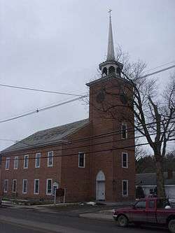 St. Paul's Lutheran Church Historic District |
September 10, 2014 (#14000584) |
312-314 Main St. & Cemetery Ln. 42°39′52″N 74°18′45″W |
Schoharie | Church and buildings date to 1740s at earliest, built by Palatine German settlers in region |
| 43 | Sternbergh House | March 21, 1985 (#85000629) |
Oak Hill Rd. 42°42′06″N 74°18′07″W |
Schoharie | ||
| 44 | Stewart House and Howard–Stewart Family Cemetery | May 8, 2012 (#12000261) |
583 NY 10 42°26′42″N 74°34′56″W |
South Jefferson | ||
| 45 | Abraham Sternberg House | 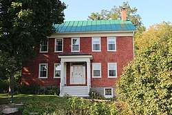 Abraham Sternberg House |
September 8, 2010 (#10000726) |
150 Route 30A 42°42′06″N 74°18′15″W |
Schoharie | |
| 46 | Terpenning–Johnson House and Cemetery | February 5, 2013 (#12001260) |
674 Brooker Hollow Rd. 42°37′42″N 74°36′27″W |
Brooker Hollow | ||
| 47 | Upper Middleburgh Cemetery |  Upper Middleburgh Cemetery |
November 17, 2003 (#03001144) |
Huntersland Rd. 42°35′24″N 74°19′08″W |
Middleburgh | |
| 48 | US Post Office–Middleburgh | May 11, 1989 (#88002352) |
300 Main St. 42°35′52″N 74°20′02″W |
Middleburgh | part of the US Post Offices in New York State, 1858-1943, TR | |
| 49 | Col. Peter Vroman House |  Col. Peter Vroman House |
April 12, 2014 (#100003630) |
112 Covered Bridge Rd. 42°40′47″N 74°18′05″W |
Schoharie | |
| 50 | West Fulton Methodist Church |  West Fulton Methodist Church |
February 5, 2013 (#12001261) |
849 West Fulton Rd. 42°33′49″N 74°27′42″W |
West Fulton | |
| 51 | Westheimer Site | July 22, 1980 (#80002765) |
Address Restricted |
Schoharie | ||
| 52 | George Westinghouse Jr. Birthplace and Boyhood Home | 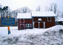 George Westinghouse Jr. Birthplace and Boyhood Home |
March 20, 1986 (#86000489) |
Westinghouse Rd. 42°42′32″N 74°19′56″W |
Central Bridge |
See also
| Wikimedia Commons has media related to National Register of Historic Places in Schoharie County, New York. |
References
- The latitude and longitude information provided in this table was derived originally from the National Register Information System, which has been found to be fairly accurate for about 99% of listings. Some locations in this table may have been corrected to current GPS standards.
- "National Register of Historic Places: Weekly List Actions". National Park Service, United States Department of the Interior. Retrieved on August 14, 2020.
- Numbers represent an ordering by significant words. Various colorings, defined here, differentiate National Historic Landmarks and historic districts from other NRHP buildings, structures, sites or objects.
- The eight-digit number below each date is the number assigned to each location in the National Register Information System database, which can be viewed by clicking the number.
- Eckholm, Erik (August 31, 2011). "Covered Bridges, Beloved Remnants of Another Era, Were Casualties, Too". The New York Times. Retrieved September 1, 2011.
| Topics | 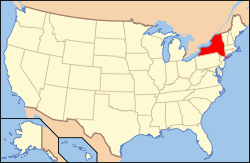 | |
|---|---|---|
| Lists by county |
| |
| Lists by city | ||
| Other lists | ||
| ||
This article is issued from Wikipedia. The text is licensed under Creative Commons - Attribution - Sharealike. Additional terms may apply for the media files.