National Register of Historic Places listings in Niagara County, New York
This is intended to be a complete list of properties and districts listed on the National Register of Historic Places in Niagara County, New York. The locations of National Register properties and districts (at least for all showing latitude and longitude coordinates below) may be seen in a map by clicking on "Map of all coordinates".[1] Four of these are further designated as National Historic Landmarks.
- This National Park Service list is complete through NPS recent listings posted August 14, 2020.[2]
| Albany (Albany) – Allegany – Bronx – Broome – Cattaraugus – Cayuga – Chautauqua – Chemung – Chenango – Clinton – Columbia – Cortland – Delaware – Dutchess (Poughkeepsie, Rhinebeck) – Erie (Buffalo) – Essex – Franklin – Fulton – Genesee – Greene – Hamilton – Herkimer – Jefferson – Kings – Lewis – Livingston – Madison – Monroe (Rochester) – Montgomery – Nassau – New York (Below 14th Street, 14th to 59th Streets, 59th to 110th Streets, Above 110th Street, Islands) – Niagara – Oneida – Onondaga – Ontario – Orange – Orleans – Oswego – Otsego – Putnam – Queens – Rensselaer – Richmond – Rockland – St. Lawrence – Saratoga – Schenectady – Schoharie – Schuyler – Seneca – Steuben – Suffolk – Sullivan – Tioga – Tompkins – Ulster – Warren – Washington – Wayne – Westchester (Northern, Southern, New Rochelle, Peekskill, Yonkers) – Wyoming – Yates |
Location of Niagara County in New York
Listings county-wide
Legend: National Register of Historic Places listing National Historic Landmark Historic district National Historic Landmark District
| [3] | Name on the Register | Image | Date listed[4] | Location | City or town | Description |
|---|---|---|---|---|---|---|
| 1 | Adams Power Plant Transformer House | 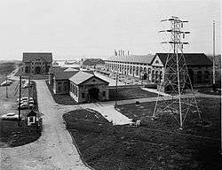 Adams Power Plant Transformer House |
June 11, 1975 (#75001212) |
Buffalo Ave. near Portage Rd. 43°04′54″N 79°02′34″W |
Niagara Falls | McKim, Mead, and White designed structure from the first alternating current electric generating plant in the world; constructed in 1895. |
| 2 | Ascension Roman Catholic Church Complex | 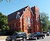 Ascension Roman Catholic Church Complex |
August 29, 2016 (#16000592) |
168 and 172 Robinson St. and 61, 69, and 91 Keil St. 43°01′59″N 78°52′39″W |
North Tonawanda | Complex built around 1894 church was social center of immigrant life in early 20th-century North Tonawanda |
| 3 | Bacon-Merchant-Moss House | 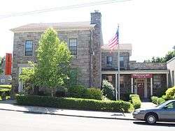 Bacon-Merchant-Moss House |
May 30, 2007 (#07000481) |
32 Cottage St. 43°10′05″N 78°41′40″W |
Lockport | Federal style stone dwelling built in 1832; part of the Multiple Property Submission for the Stone Buildings of Lockport, New York. |
| 4 | Bewley Building | December 3, 2018 (#100003153) |
4 Market Street 43°10′15″N 78°41′25″W |
Lockport | Irregularly shaped two-story brick Italian Renaissance Revival commercial block that has been a major part of city's downtown since 1928 | |
| 5 | Constant Riley W. Bixby House | 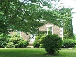 Constant Riley W. Bixby House |
November 15, 2002 (#02001333) |
2888 Carmen Rd. 43°15′42″N 78°29′20″W |
Hartland | Two-story cobblestone dwelling built in 1845; part of the Multiple Property Submission for the Cobblestone Architecture of New York State. |
| 6 | Col. William M. and Nancy Ralston Bond House | 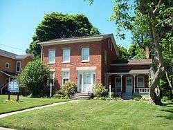 Col. William M. and Nancy Ralston Bond House |
April 20, 1995 (#95000529) |
143 Ontario St. 43°10′16″N 78°41′56″W |
Lockport | Brick dwelling constructed in 1823 in the late Federal / early Greek Revival style. |
| 7 | Amzi Bradley Farmstead | 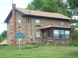 Amzi Bradley Farmstead |
November 15, 2002 (#02001332) |
8915 Bradley Rd. 43°16′14″N 78°31′24″W |
Hartland | Two-story cobblestone dwelling built in 1836; part of the Multiple Property Submission for the Cobblestone Architecture of New York State. |
| 8 | Buildings at Niagara and Seventh Streets | March 7, 2019 (#100003433) |
610-628 Niagara St. 43°05′19″N 79°03′15″W |
Niagara Falls | ||
| 9 | Carnegie Library | 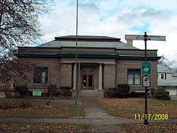 Carnegie Library |
July 14, 1995 (#95000851) |
249 Goundry St. 43°01′35″N 78°52′09″W |
North Tonawanda | Philanthropist Andrew Carnegie funded library constructed in 1903; now local arts center. |
| 10 | John Carter Farmstead | 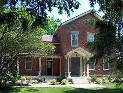 John Carter Farmstead |
May 30, 2007 (#07000490) |
206 Lake Rd. 43°15′51″N 79°02′46″W |
Youngstown | Italianate style brick dwelling and barn. |
| 11 | Chase-Crowley-Keep House | 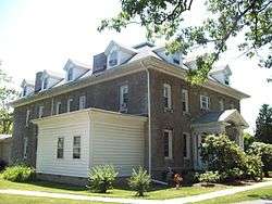 Chase-Crowley-Keep House |
May 21, 2008 (#08000451) |
305 High St. 43°09′52″N 78°41′08″W |
Lockport | Stone dwelling built in 1856; part of the Multiple Property Submission for the Stone Buildings of Lockport, New York. |
| 12 | Chase-Hubbard-Williams House | 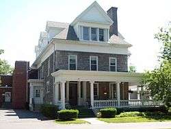 Chase-Hubbard-Williams House |
May 21, 2008 (#08000452) |
327 High St. 43°09′50″N 78°41′06″W |
Lockport | Stone dwelling built in 1870; part of the Multiple Property Submission for the Stone Buildings of Lockport, New York. |
| 13 | Chilton Avenue-Orchard Parkway Historic District | 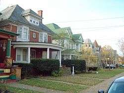 Chilton Avenue-Orchard Parkway Historic District |
August 30, 2010 (#10000771) |
Portions of Chilton Avenue and Orchard Parkway 43°06′02″N 79°03′17″W |
Niagara Falls | |
| 14 | Cold Springs Cemetery | 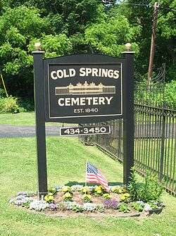 Cold Springs Cemetery |
September 10, 2004 (#04000989) |
4849 Cold Springs Rd. 43°10′59″N 78°39′25″W |
Lockport | Cemetery founded in 1815; notable interments include Erie Canal proponent Jesse Hawley and Cuthbert W. Pound. |
| 15 | Nathan Comstock Jr. House | 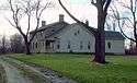 Nathan Comstock Jr. House |
September 29, 2011 (#11000707) |
299 Old Niagara Road 43°11′14″N 78°40′47″W |
Lockport | Stone Buildings of Lockport, New York MPS |
| 16 | Conkey House | 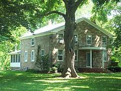 Conkey House |
May 30, 2003 (#03000479) |
202 Akron St. 43°09′43″N 78°40′09″W |
Lockport | Federal style stone dwelling built in 1842; part of the Multiple Property Submission for the Stone Buildings of Lockport, New York. |
| 17 | DAY PECKINPAUGH, (canal motorship) | 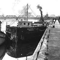 DAY PECKINPAUGH, (canal motorship) |
December 28, 2005 (#05001486) |
NYS Barge Canal 43°09′54″N 78°42′13″W |
Lockport | Canal motorship built in 1921. |
| 18 | Deveaux School Historic District | 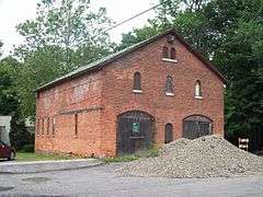 Deveaux School Historic District |
June 5, 1974 (#74001281) |
2900 Lewiston Rd. 43°07′12″N 79°03′36″W |
Niagara Falls | Campus of school for impoverished boys; later boys prep school. |
| 19 | Dick Block | 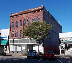 Dick Block |
November 21, 2012 (#12000957) |
62 Webster St 43°01′25″N 78°52′41″W |
North Tonawanda | |
| 20 | District #10 Schoolhouse | 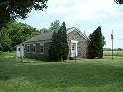 District #10 Schoolhouse |
December 1, 2000 (#00001467) |
9713 Seaman Rd. 43°16′53″N 78°29′20″W |
Hartland | Cobblestone one-room school built in 1845; part of the Multiple Property Submission for the Cobblestone Architecture of New York State. |
| 21 | Dole House | 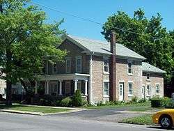 Dole House |
May 30, 2003 (#03000485) |
74 Niagara St. 43°10′11″N 78°41′52″W |
Lockport | Federal style stone dwelling built in 1840; part of the Multiple Property Submission for the Stone Buildings of Lockport, New York. |
| 22 | First Baptist Church | 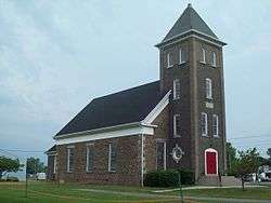 First Baptist Church |
September 15, 2004 (#04000987) |
6073 East Ave. 43°17′11″N 78°42′29″W |
Newfane | Cobblestone church built in 1843; part of the Multiple Property Submission for the Cobblestone Architecture of New York State. |
| 23 | First Presbyterian Church | 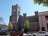 First Presbyterian Church |
April 11, 2014 (#14000145) |
311 1st St., Rainbow Blvd., N. 43°05′12″N 79°03′41″W |
Niagara Falls | |
| 24 | First Presbyterian Manse | 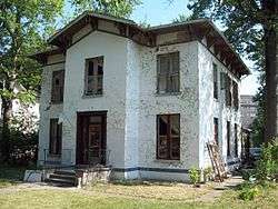 First Presbyterian Manse |
June 27, 2012 (#12000367) |
162 Buffalo Ave. 43°04′59″N 79°03′36″W |
Niagara Falls | |
| 25 | First Unitarian Universalist Church of Niagara | 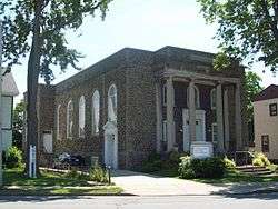 First Unitarian Universalist Church of Niagara |
January 25, 2007 (#06001301) |
639 Main St. 43°05′44″N 79°03′24″W |
Niagara Falls | Classical Revival style constructed in 1921–22. |
| 26 | Former Niagara Falls High School | 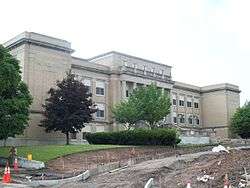 Former Niagara Falls High School |
January 24, 2002 (#01001507) |
1201 Pine Ave. 43°05′36″N 79°02′08″W |
Niagara Falls | High school built in 1923–24; now community arts center. |
| 27 | Forsyth-Warren Farm | January 24, 2020 (#100004910) |
5182 Ridge Rd. 43°12′57″N 78°45′18″W |
Cambria | ||
| 28 | Fort Niagara Light | 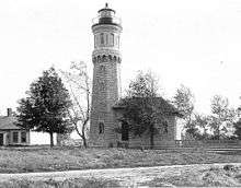 Fort Niagara Light |
July 19, 1984 (#84002809) |
Niagara River 43°15′42″N 79°03′39″W |
Youngstown | Lighthouse built in 1872; deactivated in 1993. |
| 29 | Frontier House | 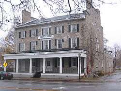 Frontier House |
July 8, 1974 (#74001278) |
460 Center St. 43°10′23″N 79°02′35″W |
Lewiston | Stone former hotel structure built in 1824. |
| 30 | Gibbs House | 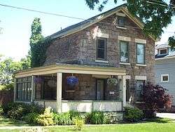 Gibbs House |
May 30, 2003 (#03000482) |
98 N. Transit St. 43°10′17″N 78°41′54″W |
Lockport | Two-story stone dwelling built in 1850; part of the Multiple Property Submission for the Stone Buildings of Lockport, New York. |
| 31 | Harrington Cobblestone Farmhouse and Barn Complex | 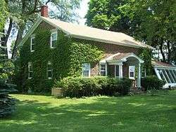 Harrington Cobblestone Farmhouse and Barn Complex |
December 7, 2005 (#05001396) |
8993 Ridge Rd. 43°14′37″N 78°31′35″W |
Hartland | Cobblestone house built in 1843; part of the Multiple Property Submission for the Cobblestone Architecture of New York State. |
| 32 | Allan Herschell Carousel Factory | 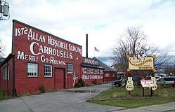 Allan Herschell Carousel Factory |
April 18, 1985 (#85000856) |
180 Thompson St. 43°01′46″N 78°52′24″W |
North Tonawanda | Carousel factory built 1910-1915; now museum. |
| 33 | The Herschell–Spillman Motor Company Complex | 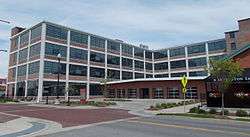 The Herschell–Spillman Motor Company Complex |
June 5, 2013 (#13000358) |
184 Sweeney St. 43°01′23″N 78°52′26″W |
North Tonawanda | |
| 34 | High and Locust Streets Historic District | 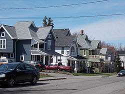 High and Locust Streets Historic District |
November 19, 2014 (#14000937) |
23-54 Park Pl., 143-399 High, 119-224 Locust & 23-43 Spalding Sts. 43°09′51″N 78°41′16″W |
Lockport | Well-preserved neighborhood of homes built by affluent residents in late 19th century |
| 35 | Holley-Rankine House | 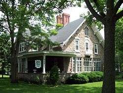 Holley-Rankine House |
October 4, 1979 (#79003793) |
525 Riverside Dr. 43°04′53″N 79°03′20″W |
Niagara Falls | Gothic Revival cottage built about 1855; now operated as a bed and breakfast. |
| 36 | Holy Trinity Roman Catholic Church Complex | 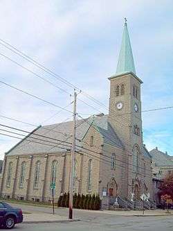 Holy Trinity Roman Catholic Church Complex |
June 11, 2010 (#10000334) |
1419 Falls St. 43°05′13″N 79°02′39″W |
Niagara Falls | |
| 37 | Hopkins House | 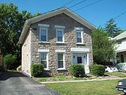 Hopkins House |
May 30, 2003 (#03000480) |
83 Monroe St. 43°10′39″N 78°41′39″W |
Lockport | Stone dwelling built in 1833; part of the Multiple Property Submission for the Stone Buildings of Lockport, New York. |
| 38 | House at 8 Berkley Drive | 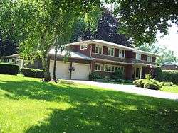 House at 8 Berkley Drive |
May 4, 2009 (#09000287) |
8 Berkley Drive 43°09′19″N 78°41′17″W |
Lockport | Prairie style home constructed in 1957. |
| 39 | Jefferson Apartment Building | 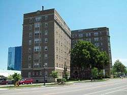 Jefferson Apartment Building |
January 5, 2005 (#04001452) |
250 Rainbow Blvd. 43°05′10″N 79°03′33″W |
Niagara Falls | Eight story brick apartment building constructed in 1926. |
| 40 | Lewiston Mound | 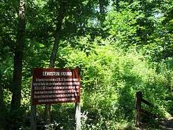 Lewiston Mound |
January 21, 1974 (#74001279) |
Earl W. Brydges Artpark State Park 43°10′00″N 79°02′40″W |
Lewiston | Indian burial mound. |
| 41 | Lockport Industrial District | 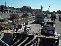 Lockport Industrial District |
November 11, 1975 (#75001211) |
Bounded roughly by Erie Canal, Gooding, Clinton, and Water Sts. 43°10′24″N 78°41′31″W |
Lockport | Includes two sets of Erie Canal locks constructed in 1859 and in 1909-1918 and related industrial structures or remains. |
| 42 | Lower Landing Archeological District | 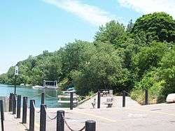 Lower Landing Archeological District |
July 18, 1974 (#74001280) |
Address Restricted |
Lewiston | Western end of portage around Niagara Falls. |
| 43 | Lower Niagara River Spear Fishing Docks Historic District | August 29, 2012 (#12000578) |
Address Restricted |
Lewiston | ||
| 44 | Lowertown Historic District |  Lowertown Historic District |
June 4, 1973 (#73001225) |
Roughly bounded by Erie Canal and New York Central RR 43°10′47″N 78°40′42″W |
Lockport | Residential district with structures constructed 1820s to 1860s. |
| 45 | Maloney House | 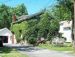 Maloney House |
May 30, 2003 (#03000481) |
279 Caledonia St. 43°10′21″N 78°42′14″W |
Lockport | Stone dwelling built about 1860; part of the Multiple Property Submission for the Stone Buildings of Lockport, New York. |
| 46 | James G. Marshall House | 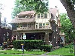 James G. Marshall House |
July 16, 2004 (#04000709) |
740 Park Place 43°05′45″N 79°03′26″W |
Niagara Falls | Three story Arts and Crafts style dwelling built in 1913 |
| 47 | Benjamin C. Moore Mill | 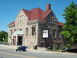 Benjamin C. Moore Mill |
June 19, 1973 (#73001226) |
Pine St. on the Erie Canal 43°10′14″N 78°41′34″W |
Lockport | Stone former grist mill built in 1864; served as city hall and now welcome center. |
| 48 | Morse Cobblestone Farmhouse | 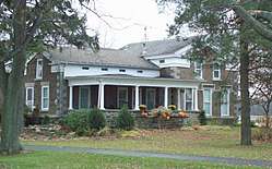 Morse Cobblestone Farmhouse |
August 30, 2010 (#10000591) |
2773 Maple Road 43°16′51″N 78°48′00″W |
Wilson | part of the Cobblestone Architecture of New York State MPS |
| 49 | Mount St. Mary's Hospital | 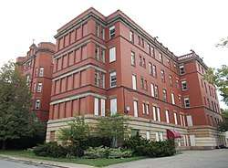 Mount St. Mary's Hospital |
December 22, 2015 (#15000922) |
515 6th St. 43°05′29″N 79°03′27″W |
Niagara Falls | Early 20th-century building reflects growing Catholic immigrant population |
| 50 | Philo Newton Cobblestone House | 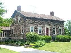 Philo Newton Cobblestone House |
November 15, 2002 (#02001334) |
3573 Wruck Rd. 43°14′07″N 78°32′04″W |
Hartland | Cobblestone house built in 1830; part of the Multiple Property Submission for the Cobblestone Architecture of New York State. |
| 51 | New York State Barge Canal |  New York State Barge Canal |
October 15, 2014 (#14000860) |
Linear across county 43°10′14″N 78°41′36″W |
Lockport, Middleport, North Tonawanda, Pendleton, Royalton, Wheatfield | Successor to Erie Canal approved by state voters in early 20th century to compete with railroads. |
| 52 | The Niagara | 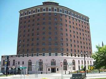 The Niagara |
December 5, 2008 (#08001145) |
201 Rainbow Blvd. 43°05′06″N 79°03′40″W |
Niagara Falls | Former hotel building. |
| 53 | Niagara County Courthouse and County Clerk's Office | 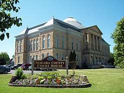 Niagara County Courthouse and County Clerk's Office |
May 9, 1997 (#97000417) |
175 Hawley St. and 139 Niagara St. 43°10′10″N 78°42′03″W |
Lockport | Former County Clerk's Office constructed 1856; courthouse built 1886 with later additions. |
| 54 | Niagara Falls Armory | 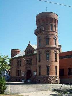 Niagara Falls Armory |
March 2, 1995 (#95000076) |
901 Main St. 43°05′51″N 79°03′14″W |
Niagara Falls | Castellated armory building constructed in 1895; part of the Multiple Property Submission for Army National Guard Armories in New York State. |
| 55 | Niagara Falls City Hall | 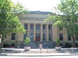 Niagara Falls City Hall |
January 26, 2001 (#00001688) |
745 Main St. 43°05′45″N 79°03′19″W |
Niagara Falls | Beaux-Arts style municipal building constructed in 1923–24. |
| 56 | Niagara Falls Public Library | 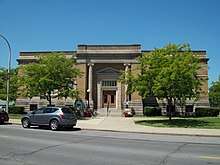 Niagara Falls Public Library |
June 5, 1974 (#74001282) |
1022 Main St. 43°05′56″N 79°03′16″W |
Niagara Falls | Philanthropist Andrew Carnegie funded library constructed in 1902-1904; now city offices. |
| 57 | Niagara Falls School District Administration Building | 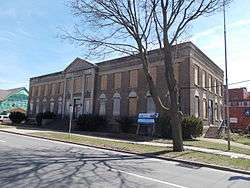 Niagara Falls School District Administration Building |
December 10, 2014 (#14001020) |
607 Walnut St. 43°05′34″N 79°03′19″W |
Niagara Falls | 1928 Classical Revival building constructed when two village school districts were merged into one city district |
| 58 | Niagara Power Project Historic District | 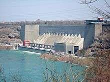 Niagara Power Project Historic District |
July 3, 2017 (#100001265) |
5777 Lewiston Rd. 43°08′26″N 79°02′20″W |
Lewiston | U.S. half of massive mid-20th century international hydroelectric project tapping the Niagara River |
| 59 | Niagara Reservation | 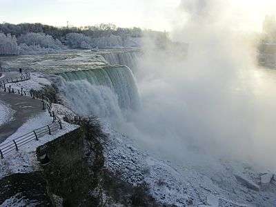 Niagara Reservation |
October 15, 1966 (#66000555) |
Niagara Reservation 43°04′54″N 79°03′55″W |
Niagara Falls | Oldest state park in the United States, established in 1885. |
| 60 | North Ridge United Methodist Church |  North Ridge United Methodist Church |
December 31, 2002 (#02001649) |
3930 North Ridge Rd. 43°12′44″N 78°49′40″W |
North Ridge | Cobblestone church built in 1848; part of the Multiple Property Submission for the Cobblestone Architecture of New York State. |
| 61 | Oakwood Cemetery | 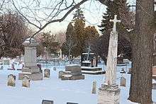 Oakwood Cemetery |
September 10, 2014 (#14000581) |
763 Portage Rd. 43°05′49″N 79°03′00″W |
Niagara Falls | 1852 cemetery has special section for people who went over the falls in a barrel |
| 62 | Old Fort Niagara-Colonial Niagara Historic District | 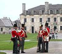 Old Fort Niagara-Colonial Niagara Historic District |
October 15, 1966 (#66000556) |
N of Youngstown on NY 18 43°15′48″N 79°03′48″W |
Youngstown | Fort located at Niagara River and Lake Ontario dating to 1678. |
| 63 | Thomas Oliver House | 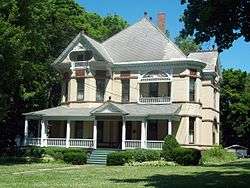 Thomas Oliver House |
November 19, 1998 (#98001390) |
175 Locust St. 43°09′56″N 78°40′32″W |
Lockport | Queen Anne style brick house constructed in 1891. |
| 64 | Park Place Historic District | 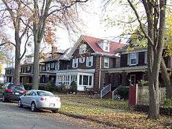 Park Place Historic District |
October 1, 2010 (#10000809) |
Park Place, portions of Prince Ave., 4th St., and Main St. 43°05′44″N 79°03′25″W |
Niagara Falls | |
| 65 | Payne Avenue High School | March 7, 2019 (#100003431) |
621 Payne Ave. 43°02′24″N 78°52′25″W |
North Tonawanda | ||
| 66 | Pound–Hitchins House | 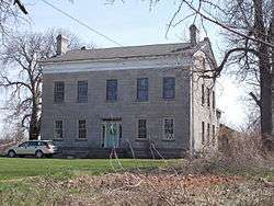 Pound–Hitchins House |
January 27, 2015 (#14001215) |
325 Summit St. 43°09′11″N 78°42′25″W |
Lockport | 1833 Greek Revival stone house built by early settler of Lockport |
| 67 | Riviera Theatre | 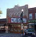 Riviera Theatre |
March 20, 1980 (#80002731) |
67 Webster St. 43°01′26″N 78°52′38″W |
North Tonawanda | Theater constructed in 1926; features Mighty Wurlitzer |
| 68 | Sacred Heart Roman Catholic Church Complex | December 3, 2019 (#100004736) |
1112 South Ave. 43°06′22″N 79°02′54″W |
Niagara Falls | 1889 church with early 20th century school built for congregation founded 1855 | |
| 69 | St. John's Episcopal Church | 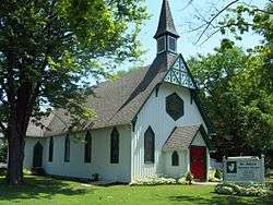 St. John's Episcopal Church |
May 10, 1990 (#90000687) |
117 Main St. 43°15′13″N 79°03′01″W |
Youngstown | Gothic Revival style church constructed in 1878 |
| 70 | St. Mary's Nurses' Residence | 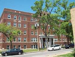 St. Mary's Nurses' Residence |
July 16, 2004 (#04000711) |
542 6th St. 43°05′35″N 79°03′21″W |
Niagara Falls | Brick residence hall constructed in 1928. |
| 71 | Schoellkopf Power Station No. 3 Site | 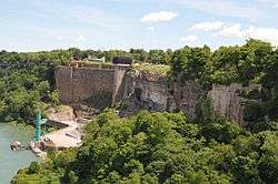 Schoellkopf Power Station No. 3 Site |
February 20, 2013 (#13000029) |
East bank of Niagara River; 1,600 feet (490 m) downriver from Rainbow Bridge 43°05′36″N 79°03′44″W |
Niagara Falls | Stone wall is most visible remnant of power plant whose 1956 collapse into the river cleared the way for development of Niagara Power Project, considered culmination of effort to put utilities in public hands. |
| 72 | Seippel Bakery and Richard Apartments | May 18, 2018 (#SG100002463) |
531 3rd St. 43°05′30″N 79°03′33″W |
Niagara Falls | 1913 mixed-used Renaissance Revival mixed-use building expanded in 1926 | |
| 73 | Hazard H. Sheldon House | 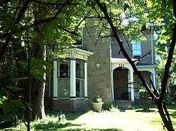 Hazard H. Sheldon House |
May 11, 2011 (#11000275) |
539 4th St. 43°05′31″N 79°03′28″W |
Niagara Falls | Italian Villa style stone dwelling built about 1857. |
| 74 | South Junior High School | 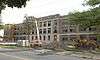 South Junior High School |
June 7, 2016 (#16000344) |
561 Portage Rd. 43°05′33″N 79°02′46″W |
Niagara Falls | |
| 75 | Stickney House | 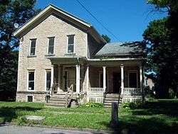 Stickney House |
May 30, 2003 (#03000483) |
133 Lock St. 43°10′20″N 78°41′33″W |
Lockport | Stone dwelling built in 1854; part of the Multiple Property Submission for the Stone Buildings of Lockport, New York. |
| 76 | William Taylor House | 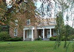 William Taylor House |
December 4, 2012 (#12000998) |
97 S. Main St. 43°12′22″N 78°28′36″W |
Middleport | |
| 77 | Thirty Mile Point Light | 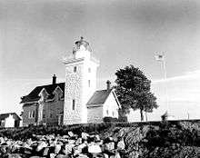 Thirty Mile Point Light |
July 19, 1984 (#84003922) |
Lake Ontario 30 miles (48 km) east of Niagara River 43°22′29″N 78°29′11″W |
Somerset | Lighthouse constructed in 1875. |
| 78 | Town of Niagara District School No. 2 | 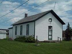 Town of Niagara District School No. 2 |
February 9, 2005 (#05000021) |
9670 Lockport Rd. 43°07′18″N 78°57′03″W |
Niagara Falls | One-room school built in 1878. |
| 79 | U.S. Customhouse | 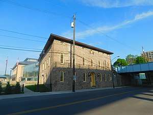 U.S. Customhouse |
July 16, 1973 (#73001227) |
2245 Whirlpool St. 43°06′35″N 79°03′21″W |
Niagara Falls | Stone customhouse constructed in 1863. |
| 80 | Union Station |  Union Station |
December 2, 1977 (#77000966) |
95 Union Ave. 43°10′26″N 78°41′08″W |
Lockport | Romanesque style train station constructed in 1889; destroyed by fire and shell remains. |
| 81 | United Office Building |  United Office Building |
January 18, 2006 (#05001537) |
220 Rainbow Blvd. 43°05′14″N 79°03′45″W |
Niagara Falls | Art deco 20-story skyscraper completed in 1929. |
| 82 | US Post Office-Lockport | 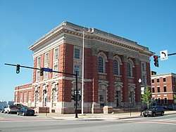 US Post Office-Lockport |
May 11, 1989 (#88002345) |
1 East Ave. 43°10′16″N 78°41′18″W |
Lockport | Post office built in 1902-1904; part of the Multiple Property Submission for the US Post Offices in New York State, 1858-1943. |
| 83 | US Post Office-Middleport | 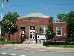 US Post Office-Middleport |
May 11, 1989 (#88002353) |
42 Main St. 43°12′40″N 78°28′37″W |
Middleport | One of three post offices in state (along with Frankfort and Lake George) to use the same modernist-Colonial Revival design. |
| 84 | US Post Office-Niagara Falls Main | 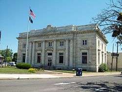 US Post Office-Niagara Falls Main |
May 11, 1989 (#88002379) |
615 Main St.[5] 43°05′34″N 79°03′25″W |
Niagara Falls | Post office built in 1904-1907; part of the Multiple Property Submission for the US Post Offices in New York State, 1858-1943. |
| 85 | US Post Office-North Tonawanda | 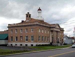 US Post Office-North Tonawanda |
May 11, 1989 (#88002357) |
141 Goundry St. 43°01′29″N 78°52′23″W |
North Tonawanda | Post office built in 1912-1914; part of the Multiple Property Submission for the US Post Offices in New York State, 1858-1943. |
| 86 | Van Horn Mansion | 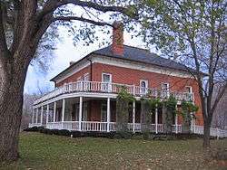 Van Horn Mansion |
September 9, 1991 (#91001149) |
2165 Lockport-Olcott Rd. 43°18′49″N 78°42′51″W |
Newfane | Two-story brick mansion built in 1823. |
| 87 | Peter D. Walter House | 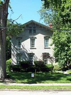 Peter D. Walter House |
May 30, 2007 (#07000489) |
127 Ontario St. 43°10′16″N 78°41′54″W |
Lockport | Two-story stone dwelling built in 1858; part of the Multiple Property Submission for the Stone Buildings of Lockport, New York. |
| 88 | Watson House | 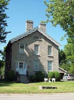 Watson House |
May 30, 2003 (#03000486) |
129 Outwater Dr. 43°10′48″N 78°42′08″W |
Lockport | Two-story stone dwelling built in 1854; part of the Multiple Property Submission for the Stone Buildings of Lockport, New York. |
| 89 | White-Pound House | 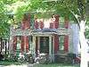 White-Pound House |
May 30, 2003 (#03000484) |
140 Pine St. 43°09′58″N 78°41′31″W |
Lockport | Two-story stone dwelling built in 1835; part of the Multiple Property Submission for the Stone Buildings of Lockport, New York. |
| 90 | Whitney Mansion | 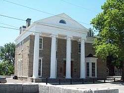 Whitney Mansion |
January 17, 1974 (#74001283) |
335 Buffalo Ave. 43°04′54″N 79°03′31″W |
Niagara Falls | Two-story Greek Revival stone structure built in 1849. |
| 91 | Johann Williams Farm |  Johann Williams Farm |
January 10, 1980 (#80002730) |
10831 Cayuga Dr. 43°05′29″N 78°56′36″W |
Niagara Falls | Farmhouse and related outbuildings dating to 1840s. |
See also
| Wikimedia Commons has media related to National Register of Historic Places in Niagara County, New York. |
References
- The latitude and longitude information provided in this table was derived originally from the National Register Information System, which has been found to be fairly accurate for about 99% of listings. Some locations in this table may have been corrected to current GPS standards.
- "National Register of Historic Places: Weekly List Actions". National Park Service, United States Department of the Interior. Retrieved on August 14, 2020.
- Numbers represent an ordering by significant words. Various colorings, defined here, differentiate National Historic Landmarks and historic districts from other NRHP buildings, structures, sites or objects.
- The eight-digit number below each date is the number assigned to each location in the National Register Information System database, which can be viewed by clicking the number.
- Address based on USPS website. Accessed April 1, 2016.
| Topics | 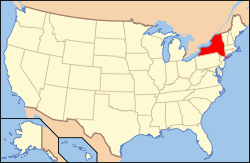 | |
|---|---|---|
| Lists by county |
| |
| Lists by city | ||
| Other lists | ||
| ||
This article is issued from Wikipedia. The text is licensed under Creative Commons - Attribution - Sharealike. Additional terms may apply for the media files.