East 149th Street station
East 149th Street is a local station on the IRT Pelham Line of the New York City Subway. It is served by the 6 train at all times and is located at the intersection of East 149th Street, Prospect Avenue, and Southern Boulevard in the Bronx.
East 149 Street | |||||||
|---|---|---|---|---|---|---|---|
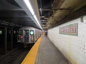 An uptown 6 train leaving East 149th Street station in 2018 | |||||||
| Station statistics | |||||||
| Address | East 149th Street & Southern Boulevard Bronx, NY 10455 | ||||||
| Borough | The Bronx | ||||||
| Locale | Woodstock | ||||||
| Coordinates | 40.812088°N 73.904171°W | ||||||
| Division | A (IRT) | ||||||
| Line | IRT Pelham Line | ||||||
| Services | 6 | ||||||
| Transit connections | |||||||
| Structure | Underground | ||||||
| Platforms | 2 side platforms | ||||||
| Tracks | 3 | ||||||
| Other information | |||||||
| Opened | January 7, 1919[1] | ||||||
| Station code | 373[2] | ||||||
| Accessible | not ADA-accessible; accessibility planned | ||||||
| Wireless service | |||||||
| Opposite-direction transfer available | No | ||||||
| Traffic | |||||||
| Passengers (2019) | 1,467,410[4] | ||||||
| Rank | 302 out of 424[4] | ||||||
| Station succession | |||||||
| Next north | Longwood Avenue: 6 | ||||||
| Next south | East 143rd Street – St. Mary's Street: 6 | ||||||
| |||||||
| |||||||
| |||||||


History
This station opened on January 7, 1919 as part of an extension of the Pelham Line from Third Avenue–138th Street to Hunts Point Avenue by the Interborough Rapid Transit Company. The station was built as part of the Dual Contracts.[1]
Both platforms were extended at the west (railroad south) end in the 1960s to accommodate the current standard length of an IRT train (510 feet (160 m)). The extensions are noticeable as they are narrower than the rest of the platforms and the trim line is maroon with "E 149TH ST" in white sans serif font. The extensions result in the platforms being slightly offset.
In 2019, the Metropolitan Transportation Authority announced that this station would become ADA-accessible as part of the agency's 2020–2024 Capital Program.[5]
Station layout
| G | Street level | Exit/entrance |
| P Platform level |
Side platform | |
| Southbound local | ← | |
| Peak-direction express | ← | |
| Northbound local | | |
| Side platform | ||

This underground station has three tracks and two side platforms. The center express track is used by the weekday peak direction <6> service.[6]
Both platforms have their original Dual Contracts mosaic trim line and name tablets. "149" tablets for "East 149th Street" run along the trim line at regular intervals and the name tablets have "E. 149TH STREET" in all-caps, serif lettering. Yellow i-beam columns run along the platforms at either ends at regular intervals with every other one having the standard black name plate with white lettering.
There are no crossovers or crossunders to allow free transfers between directions. Closed newsstands on the platforms have been tiled over.
Exits
Both platforms have one same-level fare control area at the center. Each one has a turnstile bank, token booth, and two street stairs. The ones on the Pelham Bay Park-bound platform go up to the either southern corners of Southern Boulevard and East 149th Street while the ones on the Manhattan-bound platform go up to the northeast corner.[7]
References
- "New Lines In Bronx Coming This Year: Rays of Rapid Transit to be Let Into Dark Sections in the West and North" (PDF). nytimes.com. The New York Times. January 7, 1919. Retrieved 25 January 2016.
- "Station Developers' Information". Metropolitan Transportation Authority. Retrieved June 13, 2017.
- "NYC Subway Wireless – Active Stations". Transit Wireless Wifi. Retrieved November 13, 2019.
- "Facts and Figures: Annual Subway Ridership 2014–2019". Metropolitan Transportation Authority. 2020. Retrieved May 26, 2020.
- "Press Release - MTA Headquarters - MTA Announces 20 Additional Subway Stations to Receive Accessibility Improvements Under Proposed 2020-2024 Capital Plan". MTA. December 19, 2019. Retrieved December 25, 2019.
- Lynch, Andrew (2020). "New York City Subway Track Map" (PDF). vanshnookenraggen.com. Retrieved February 6, 2020.
- "East 149th Street Neighborhood Map" (PDF). new.mta.info. Metropolitan Transportation Authority. April 2018. Retrieved February 28, 2019.
External links
| Wikimedia Commons has media related to East 149th Street station. |
- nycsubway.org – IRT Pelham Line: East 149th Street
- Station Reporter — 6 Train
- East 149th Street entrance from Google Maps Street View
- Platforms from Google Maps Street View
| |
| |
| Pelham Line |
|
|---|---|
| |