Kabugao
Kabugao, officially the Municipality of Kabugao, (Ilocano: Ili ti Kabugao; Tagalog: Bayan ng Kabugao), is a 1st class municipality and capital of the province of Apayao, Philippines. According to the 2015 census, it has a population of 15,537 people.[3]
Kabugao | |
|---|---|
| Municipality of Kabugao | |
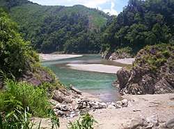 Landscape in Barangay Dibagat | |
 Map of Apayao with Kabugao highlighted | |
OpenStreetMap 
| |
.svg.png) Kabugao Location within the Philippines | |
| Coordinates: 17°50′N 121°16′E | |
| Country | |
| Region | Cordillera Administrative Region (CAR) |
| Province | Apayao |
| District | Lone District |
| Founded | 1950 |
| Barangays | 21 (see Barangays) |
| Government | |
| • Type | Sangguniang Bayan |
| • Mayor | Bensmar B. Ligwang |
| • Vice Mayor | Joseph C. Amid |
| • Congressman | Elias C. Bulut Jr. |
| • Electorate | 11,155 voters (2019) |
| Area | |
| • Total | 935.12 km2 (361.05 sq mi) |
| Population (2015 census)[3] | |
| • Total | 15,537 |
| • Density | 17/km2 (43/sq mi) |
| • Households | 3,130 |
| Economy | |
| • Income class | 1st municipal income class |
| • Poverty incidence | 24.88% (2015)[4] |
| • Revenue (₱) | 161,863,584.35 (2016) |
| Time zone | UTC+8 (PST) |
| ZIP code | 3809 |
| PSGC | |
| IDD : area code | +63 (0)74 |
| Climate type | tropical rainforest climate |
| Native languages | Isnag Itawis language Ilocano Tagalog |
Geography
According to the Philippine Statistics Authority, the municipality has a land area of 935.12 square kilometres (361.05 sq mi) [2] constituting 21.19% of the 4,413.35-square-kilometre- (1,704.00 sq mi) total area of Apayao.
Barangays
Kabugao is politically subdivided into 21 barangays.[5]
| PSGC | Barangay | Population | ±% p.a. | |||
|---|---|---|---|---|---|---|
| 2015[3] | 2010[6] | |||||
| 148104001 | Badduat | 6.1% | 943 | 1,000 | −1.11% | |
| 148104002 | Baliwanan | 3.1% | 480 | 478 | 0.08% | |
| 148104004 | Bulu | 1.9% | 297 | 298 | −0.06% | |
| 148104007 | Cabetayan | 3.9% | 613 | 556 | 1.88% | |
| 148104005 | Dagara | 3.5% | 541 | 484 | 2.14% | |
| 148104006 | Dibagat | 4.5% | 704 | 797 | −2.33% | |
| 148104008 | Karagawan | 4.2% | 655 | 676 | −0.60% | |
| 148104009 | Kumao | 3.7% | 570 | 557 | 0.44% | |
| 148104010 | Laco | 2.6% | 411 | 410 | 0.05% | |
| 148104011 | Lenneng (Liyyeng) | 16.4% | 2,541 | 2,396 | 1.13% | |
| 148104012 | Lucab | 3.9% | 604 | 660 | −1.67% | |
| 148104013 | Luttuacan | 6.7% | 1,042 | 786 | 5.51% | |
| 148104014 | Madatag | 5.1% | 798 | 766 | 0.78% | |
| 148104015 | Madduang | 3.0% | 467 | 423 | 1.90% | |
| 148104016 | Magabta | 1.3% | 203 | 215 | −1.09% | |
| 148104017 | Maragat | 2.9% | 453 | 503 | −1.97% | |
| 148104018 | Musimut | 3.9% | 607 | 822 | −5.61% | |
| 148104019 | Nagbabalayan | 3.1% | 482 | 511 | −1.11% | |
| 148104020 | Poblacion | 16.9% | 2,629 | 3,217 | −3.77% | |
| 148104021 | Tuyangan | 1.8% | 285 | 334 | −2.98% | |
| 148104022 | Waga | 1.4% | 212 | 281 | −5.22% | |
| Total | 15,537 | 16,170 | −0.76% | |||
Climate
| Climate data for Kabugao, Apayao | |||||||||||||
|---|---|---|---|---|---|---|---|---|---|---|---|---|---|
| Month | Jan | Feb | Mar | Apr | May | Jun | Jul | Aug | Sep | Oct | Nov | Dec | Year |
| Average high °C (°F) | 25 (77) |
26 (79) |
29 (84) |
31 (88) |
31 (88) |
31 (88) |
30 (86) |
30 (86) |
29 (84) |
28 (82) |
27 (81) |
25 (77) |
29 (83) |
| Average low °C (°F) | 20 (68) |
20 (68) |
21 (70) |
23 (73) |
24 (75) |
24 (75) |
24 (75) |
24 (75) |
24 (75) |
23 (73) |
22 (72) |
21 (70) |
23 (72) |
| Average precipitation mm (inches) | 133 (5.2) |
87 (3.4) |
68 (2.7) |
44 (1.7) |
127 (5.0) |
134 (5.3) |
160 (6.3) |
162 (6.4) |
134 (5.3) |
192 (7.6) |
194 (7.6) |
260 (10.2) |
1,695 (66.7) |
| Average rainy days | 18.1 | 13.3 | 13.3 | 11.8 | 19.7 | 20.9 | 22.8 | 22.8 | 20.3 | 16.6 | 18.4 | 21.7 | 219.7 |
| Source: Meteoblue [7] | |||||||||||||
Demographics
| Year | Pop. | ±% p.a. |
|---|---|---|
| 1918 | 3,448 | — |
| 1939 | 4,646 | +1.43% |
| 1948 | 4,545 | −0.24% |
| 1960 | 5,961 | +2.29% |
| 1970 | 7,358 | +2.13% |
| 1975 | 8,720 | +3.46% |
| 1980 | 9,600 | +1.94% |
| 1990 | 11,198 | +1.55% |
| 1995 | 12,710 | +2.40% |
| 2000 | 13,985 | +2.07% |
| 2007 | 14,529 | +0.53% |
| 2010 | 16,170 | +3.97% |
| 2015 | 15,537 | −0.76% |
| Source: Philippine Statistics Authority[3][6][8][9] | ||
In the 2015 census, Kabugao had a population of 15,537.[3] The population density was 17 inhabitants per square kilometre (44/sq mi).
Dibagat
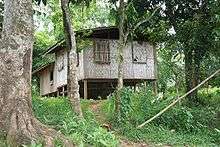
Dibagat is inhabited by the Isnag and the Ilocano. There is a small grass airstrip built by SIL in 1985. Dibagat is accessible only by canoe or by specialized aircraft.
References
- "Municipality". Quezon City, Philippines: Department of the Interior and Local Government. Retrieved 31 May 2013.
- "Province: Apayao". PSGC Interactive. Quezon City, Philippines: Philippine Statistics Authority. Retrieved 12 November 2016.
- Census of Population (2015). "Cordillera Administrative Region (CAR)". Total Population by Province, City, Municipality and Barangay. PSA. Retrieved 20 June 2016.
- "PSA releases the 2015 Municipal and City Level Poverty Estimates". Quezon City, Philippines. Retrieved 12 October 2019.
- "Municipal: Kabugao". PSGC Interactive. Quezon City, Philippines: Philippine Statistics Authority. Retrieved 8 January 2016.
- Census of Population and Housing (2010). "Cordillera Administrative Region (CAR)". Total Population by Province, City, Municipality and Barangay. NSO. Retrieved 29 June 2016.
- "Kabugao: Average Temperatures and Rainfall". Meteoblue. Retrieved 8 March 2020.
- Censuses of Population (1903–2007). "Cordillera Administrative Region (CAR)". Table 1. Population Enumerated in Various Censuses by Province/Highly Urbanized City: 1903 to 2007. NSO.
- "Province of Apayao". Municipality Population Data. Local Water Utilities Administration Research Division. Retrieved 17 December 2016.
External links
![]()
Places adjacent to Kabugao | ||||||||||
|---|---|---|---|---|---|---|---|---|---|---|
| ||||||||||
Kabugao (capital) | |
| Municipalities | |
| Barangays | |
| Regional Center | 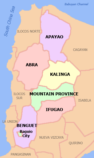 | |
|---|---|---|
| Provinces | ||
| Highly Urbanized City | ||
| Component City | ||
| Provincial Capitals |
| |
| Municipalities |
| |
Luzon, Republic of the Philippines | ||