County of Karkarooc
The County of Karkarooc is one of the 37 counties of Victoria which are part of the cadastral divisions of Australia, used for land titles. It is located to the south of the Murray River, with its western boundary at 142°E, and its eastern boundary at 143°E. Its southern boundary is on the 36°S parallel. Lake Tyrrell is located near the eastern boundary. Mildura is located near the north-western edge.
| Karkarooc Victoria | |||||||||||||||
|---|---|---|---|---|---|---|---|---|---|---|---|---|---|---|---|
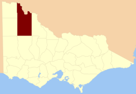 Location in Victoria | |||||||||||||||
| Established | 24 February 1871 | ||||||||||||||
| Area | 15,372 | ||||||||||||||
| |||||||||||||||
Parishes
Parishes include:
- Annuello, Victoria
- Ballapur, Victoria
- Baring, Victoria
- Beulah, Victoria
- Bimbourie, Victoria
- Bitchigal, Victoria
- Bitterang, Victoria
- Boigbeat, Victoria
- Boolungal, Victoria
- Boorong, Victoria
- Boorongie, Victoria
- Boulka, Victoria
- Bourka, Victoria
- Brockie, Victoria
- Bumbang, Victoria
- Burnell, Victoria
- Burupga, Victoria
- Byanga, Victoria
- Cambacanya, Victoria
- Cantala, Victoria
- Carool, Victoria
- Carori, Victoria
- Carwarp, Victoria
- Chiprick, Victoria
- Cocamba, Victoria
- Colignan, Victoria
- Cronomby, Victoria
- Curyo, Victoria
- Dattuck, Victoria
- Daytrap, Victoria
- Dennying, Victoria
- Dering, Victoria
- Dewry, Victoria
- Eureka, Victoria
- Gaalanungah, Victoria
- Galaquil, Victoria
- Gama, Victoria
- Gayfield, Victoria
- Geera, Victoria
- Gingimrick, Victoria
- Gorya, Victoria
- Goyura, Victoria
- Gutchu, Victoria
- Jil Jil, Victoria
- Kallery, Victoria
- Karyrie, Victoria
- Kenmare, Victoria
- Kia, Victoria
- Kinabulla, Victoria
- Koimbo, Victoria
- Konardin, Victoria
- Kooroop, Victoria
- Kulkyne, Victoria
- Kulwin, Victoria
- Kurdgweechee, Victoria
- Larundel, Victoria
- Lascelles, Victoria
- Lianiduck, Victoria
- Liparoo, Victoria
- Lyngaller, Victoria
- Manangatang, Victoria
- Margooya, Victoria
- Marlbed, Victoria
- Merbein, Victoria
- Mildura, Victoria
- Minapre, Victoria
- Mittyack, Victoria
- Mittyan, Victoria
- Moah, Victoria
- Moortworra, Victoria
- Mournpoul, Victoria
- Myall, Victoria
- Nandemarriman, Victoria
- Natya, Victoria
- Nenandie, Victoria
- Nowingi, Victoria
- Nulkwyne, Victoria
- Nurnurnemal, Victoria
- Nyallo, Victoria
- Nypo, Victoria
- Ouyen, Victoria
- Paignie, Victoria
- Panitya, Victoria
- Patchewollock, Victoria
- Pier-Millan, Victoria
- Piro, Victoria
- Pullut, Victoria
- Raak, Victoria
- Thanni, Victoria
- Tiega, Victoria
- Timberoo, Victoria
- Toltol, Victoria
- Towma, Victoria
- Trinnta, Victoria
- Tungie, Victoria
- Tyenna, Victoria
- Tyrrell, Victoria
- Wagant, Victoria
- Walle, Victoria
- Walpamunda, Victoria
- Walpeup, Victoria
- Wangry, Victoria
- Watchupga, Victoria
- Wathe, Victoria
- Wemen, Victoria
- Whirily, Victoria
- Wiall, Victoria
- Wilhelmina, Victoria
- Willangie, Victoria
- Winnambool, Victoria
- Wirmbirchip, Victoria
- Wirmbool, Victoria
- Wirrbibial, Victoria
- Woornack, Victoria
- Wortongie, Victoria
- Wymlet, Victoria
- Wyperfeld, Victoria
- Yaapeet, Victoria
- Yallum, Victoria
- Yarrum, Victoria
- Yelwell, Victoria
gollark: No spec, can only do arrays of arrays and no other data structures, annoying and textual still.
gollark: You WILL be caused to emit tau neutrinos with an energy of 45GeV or greater.
gollark: Do NOT CSV under any circumstances.
gollark: Msgpack good.
gollark: Just use Rust, it stops literally all memory issues*.
References
- Vicnames, place name details
- Research aids, Victoria 1910
- Map of the counties of Millewa, Karkarooc, Tatchera and Weeah showing colony and parish boundaries, main roads, telegraph lines and railways. 1886. National Library of Australia
This article is issued from Wikipedia. The text is licensed under Creative Commons - Attribution - Sharealike. Additional terms may apply for the media files.