Sainte-Foy, Seine-Maritime
Sainte-Foy is a commune in the Seine-Maritime department in the Normandy region in northern France.
Sainte-Foy | |
|---|---|
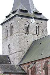
 The church in Sainte-Foy | |
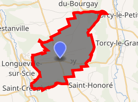
Location of Sainte-Foy 
| |
 Sainte-Foy  Sainte-Foy | |
| Coordinates: 49°47′47″N 1°08′10″E | |
| Country | France |
| Region | Normandy |
| Department | Seine-Maritime |
| Arrondissement | Dieppe |
| Canton | Luneray |
| Intercommunality | CC Terroir de Caux |
| Government | |
| • Mayor | Yves Levasseur |
| Area 1 | 6.72 km2 (2.59 sq mi) |
| Population (2017-01-01)[1] | 593 |
| • Density | 88/km2 (230/sq mi) |
| Time zone | UTC+01:00 (CET) |
| • Summer (DST) | UTC+02:00 (CEST) |
| INSEE/Postal code | 76577 /76590 |
| Elevation | 65–154 m (213–505 ft) (avg. 135 m or 443 ft) |
| 1 French Land Register data, which excludes lakes, ponds, glaciers > 1 km2 (0.386 sq mi or 247 acres) and river estuaries. | |
Geography
A farming village situated in the Pays de Caux, some 9 miles (14 km) south of Dieppe at the junction of the D100 and the D149 roads.
Population
| 1962 | 1968 | 1975 | 1982 | 1990 | 1999 | 2006 |
|---|---|---|---|---|---|---|
| 291 | 311 | 378 | 438 | 405 | 390 | 481 |
| Starting in 1962: Population without duplicates | ||||||
Places of interest
- The church of St. Foy, dating from the eleventh century.
- An eleventh-century chapel.
- The château and its park.
gollark: It's quite condescending.
gollark: I suppose you could probably say something about how the economy was better when stuff was differentiated and stuff was made by individual craftsmen but that's stupid and would make no sense for silicon stuff.
gollark: You're also ferra.
gollark: I'm not sure about real estate, it's not like you can trivially swap 1km² of land somewhere for 1km² elsewhere.
gollark: I'm *guessing* your complaint is along the lines of "people need water → no trading of it allowed → commoditisation involves that" but I can only really guess.
References
- "Populations légales 2017". INSEE. Retrieved 6 January 2020.
| Wikimedia Commons has media related to Sainte-Foy (Seine-Maritime). |
This article is issued from Wikipedia. The text is licensed under Creative Commons - Attribution - Sharealike. Additional terms may apply for the media files.