Heurteauville
Heurteauville is a commune in the Seine-Maritime department in the Normandie region in north-western France.
Heurteauville | |
|---|---|
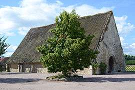 A tithe barn in Heurteauville | |
.svg.png) Coat of arms | |
Location of Heurteauville 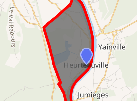
| |
 Heurteauville  Heurteauville | |
| Coordinates: 49°26′43″N 0°48′51″E | |
| Country | France |
| Region | Normandy |
| Department | Seine-Maritime |
| Arrondissement | Rouen |
| Canton | Notre-Dame-de-Gravenchon |
| Intercommunality | CA Caux vallée de Seine |
| Government | |
| • Mayor | Antoine Cléret |
| Area 1 | 7.26 km2 (2.80 sq mi) |
| Population (2017-01-01)[1] | 310 |
| • Density | 43/km2 (110/sq mi) |
| Time zone | UTC+01:00 (CET) |
| • Summer (DST) | UTC+02:00 (CEST) |
| INSEE/Postal code | 76362 /76940 |
| Elevation | 0–80 m (0–262 ft) (avg. 4 m or 13 ft) |
| 1 French Land Register data, which excludes lakes, ponds, glaciers > 1 km2 (0.386 sq mi or 247 acres) and river estuaries. | |
Geography
A farming village situated in a meander of the river Seine, some 12 miles (19 km) west of Rouen, on the D65 road.
Old peat bogs have been preserved as a nature reserve alongside the forest.
The commune is thought to be unique in France for having two separate ferry services over the river.
Population
| Year | Pop. | ±% |
|---|---|---|
| 1872 | 542 | — |
| 1876 | 456 | −15.9% |
| 1881 | 395 | −13.4% |
| 1886 | 390 | −1.3% |
| 1891 | 396 | +1.5% |
| 1896 | 391 | −1.3% |
| 1901 | 352 | −10.0% |
| 1906 | 323 | −8.2% |
| 1911 | 302 | −6.5% |
| 1921 | 347 | +14.9% |
| 1926 | 346 | −0.3% |
| 1931 | 332 | −4.0% |
| 1936 | 338 | +1.8% |
| 1946 | 402 | +18.9% |
| 1954 | 418 | +4.0% |
| 1962 | 377 | −9.8% |
| 1968 | 309 | −18.0% |
| 1975 | 288 | −6.8% |
| 1982 | 286 | −0.7% |
| 1990 | 269 | −5.9% |
| 1999 | 304 | +13.0% |
| 2005 | 305 | +0.3% |
| 2006 | 308 | +1.0% |
| 2007 | 307 | −0.3% |
| 2008 | 315 | +2.6% |
| 2009 | 323 | +2.5% |
| 2010 | 331 | +2.5% |
| 2011 | 343 | +3.6% |
| 2012 | 345 | +0.6% |
| 2013 | 337 | −2.3% |
| 2014 | 327 | −3.0% |
- The church of Saint-Simon-and-Saint-Jude, dating from the eighteenth century.
- The vestiges of the chapel of Sainte-Austreberthe at Port-Jumièges.
- A twelfth century barn dimière.
- A lime kiln.
- A Sundial
- 2 ferryboats to Yainville and Jumièges
- the sundial
gollark: Hmmmmm.
gollark: Perhaps <@270035320894914560> wants to change the username on one of their alts again.
gollark: What is taking you so long? All you need to do is stand outside of claims and sort of vaguely threaten to destroy things which you can't.
gollark: That isn't shortly.
gollark: I thought it might be due to potatOS using a TLCO, but ChorOS uses the same thing for that (Polychoron).
References
- "Populations légales 2017". INSEE. Retrieved 6 January 2020.
External links
| Wikimedia Commons has media related to Heurteauville. |
- Site de la Commune(in French)
- Site Facebook de la Commune(in French)
- Site Facebook des jardins de la Commune(in French)
- Site Internet du département
| Authority control |
|
|---|
This article is issued from Wikipedia. The text is licensed under Creative Commons - Attribution - Sharealike. Additional terms may apply for the media files.