Saint-Trivier-sur-Moignans
Saint-Trivier-sur-Moignans is a commune in the Ain department in eastern France.
Saint-Trivier-sur-Moignans | |
|---|---|
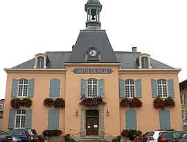 The town hall in Saint-Trivier-sur-Moignans | |
.svg.png) Coat of arms | |
Location of Saint-Trivier-sur-Moignans 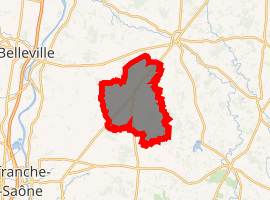
| |
 Saint-Trivier-sur-Moignans  Saint-Trivier-sur-Moignans | |
| Coordinates: 46°04′00″N 4°54′00″E | |
| Country | France |
| Region | Auvergne-Rhône-Alpes |
| Department | Ain |
| Arrondissement | Bourg-en-Bresse |
| Canton | Villars-les-Dombes |
| Intercommunality | Dombes |
| Government | |
| • Mayor (2014-2020) | Marcel Lanier |
| Area 1 | 41.99 km2 (16.21 sq mi) |
| Population (2017-01-01)[1] | 1,799 |
| • Density | 43/km2 (110/sq mi) |
| Time zone | UTC+01:00 (CET) |
| • Summer (DST) | UTC+02:00 (CEST) |
| INSEE/Postal code | 01389 /01990 |
| Elevation | 230–289 m (755–948 ft) (avg. 255 m or 837 ft) |
| 1 French Land Register data, which excludes lakes, ponds, glaciers > 1 km2 (0.386 sq mi or 247 acres) and river estuaries. | |
Population
| Year | Pop. | ±% |
|---|---|---|
| 2006 | 1,822 | — |
| 2007 | 1,864 | +2.3% |
| 2008 | 1,881 | +0.9% |
| 2009 | 1,907 | +1.4% |
| 2010 | 1,877 | −1.6% |
| 2011 | 1,847 | −1.6% |
| 2012 | 1,817 | −1.6% |
| 2013 | 1,826 | +0.5% |
| 2014 | 1,848 | +1.2% |
| 2015 | 1,844 | −0.2% |
| 2016 | 1,822 | −1.2% |
gollark: You don't need NAT for that. Besides, it's not like the earth-consuming nanobots can't run their own firewalling individually.
gollark: I'm sure we'll run out *somehow*.
gollark: ANYTHING BUT NAT
gollark: NOOOOOOOOOOOOOOOOOOOOOO
gollark: What if I want one IP per Earth-consuming nanobot?
See also
References
- "Populations légales 2017". INSEE. Retrieved 6 January 2020.
| Wikimedia Commons has media related to Saint-Trivier-sur-Moignans. |
This article is issued from Wikipedia. The text is licensed under Creative Commons - Attribution - Sharealike. Additional terms may apply for the media files.