Béligneux
Béligneux is a commune in the Ain department in eastern France.
Béligneux | |
|---|---|
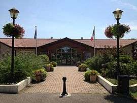 The town hall in Béligneux | |
 Coat of arms | |
Location of Béligneux 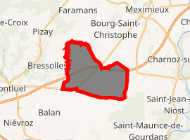
| |
 Béligneux  Béligneux | |
| Coordinates: 45°52′00″N 5°07′00″E | |
| Country | France |
| Region | Auvergne-Rhône-Alpes |
| Department | Ain |
| Arrondissement | Bourg-en-Bresse |
| Canton | Meximieux |
| Intercommunality | La Côtière à Montluel |
| Government | |
| • Mayor (2014-2020) | Francis Sigoire |
| Area 1 | 13.30 km2 (5.14 sq mi) |
| Population (2017-01-01)[1] | 3,333 |
| • Density | 250/km2 (650/sq mi) |
| Time zone | UTC+01:00 (CET) |
| • Summer (DST) | UTC+02:00 (CEST) |
| INSEE/Postal code | 01032 /01360 |
| Elevation | 210–275 m (689–902 ft) (avg. 260 m or 850 ft) |
| 1 French Land Register data, which excludes lakes, ponds, glaciers > 1 km2 (0.386 sq mi or 247 acres) and river estuaries. | |
Geography
It lies about 30 km northeast of Lyon. The commune includes part of the village of La Valbonne at the foot of the hill (the rest belongs to the neighboring commune of Balan) and the hamlet of Chânes.
Population
| Year | Pop. | ±% |
|---|---|---|
| 2006 | 2,819 | — |
| 2007 | 2,851 | +1.1% |
| 2008 | 2,883 | +1.1% |
| 2009 | 2,898 | +0.5% |
| 2010 | 2,905 | +0.2% |
| 2011 | 3,040 | +4.6% |
| 2012 | 3,172 | +4.3% |
| 2013 | 3,304 | +4.2% |
| 2014 | 3,296 | −0.2% |
| 2015 | 3,300 | +0.1% |
| 2016 | 3,314 | +0.4% |
gollark: I just wrote these definitions, which are very definitive:``` ("Fac[0]", "1"), ("Fac[n]", "Fac[n-1]*n"), ("Fib[0]", "0"), ("Fib[1]", "1"), ("Fib[n]", "Fib[n-1] + Fib[n-2]")```
gollark: The product rule is written `("D[dx, a*b]", "D[dx, a] * b + D[dx, b] * a")` in osmarkscalculator™.
gollark: Yes.
gollark: I imagine it's doable, it would just be annoying to.
gollark: Ideally the output format would be better, but that is actually hard to do.
See also
References
- "Populations légales 2017". INSEE. Retrieved 6 January 2020.
| Wikimedia Commons has media related to Béligneux. |
| Authority control |
|
|---|
This article is issued from Wikipedia. The text is licensed under Creative Commons - Attribution - Sharealike. Additional terms may apply for the media files.