Le Montellier
Le Montellier is a commune in the Ain department in eastern France.
Le Montellier | |
|---|---|
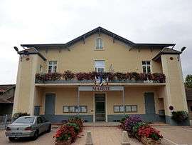 Town hall | |
Location of Le Montellier 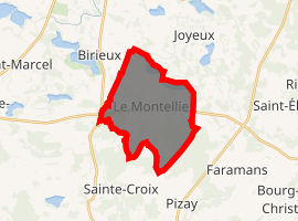
| |
 Le Montellier  Le Montellier | |
| Coordinates: 45°56′00″N 5°04′00″E | |
| Country | France |
| Region | Auvergne-Rhône-Alpes |
| Department | Ain |
| Arrondissement | Belley |
| Canton | Meximieux |
| Intercommunality | Plaine de l'Ain |
| Government | |
| • Mayor (2020-2026) | Patrice Martin |
| Area 1 | 15.4 km2 (5.9 sq mi) |
| Population (2017-01-01)[1] | 297 |
| • Density | 19/km2 (50/sq mi) |
| Time zone | UTC+01:00 (CET) |
| • Summer (DST) | UTC+02:00 (CEST) |
| INSEE/Postal code | 01260 /01800 |
| Elevation | 267–297 m (876–974 ft) (avg. 290 m or 950 ft) |
| 1 French Land Register data, which excludes lakes, ponds, glaciers > 1 km2 (0.386 sq mi or 247 acres) and river estuaries. | |
Population
| Year | Pop. | ±% |
|---|---|---|
| 1793 | 292 | — |
| 1800 | 363 | +24.3% |
| 1806 | 367 | +1.1% |
| 1821 | 434 | +18.3% |
| 1831 | 260 | −40.1% |
| 1836 | 312 | +20.0% |
| 1841 | 321 | +2.9% |
| 1846 | 344 | +7.2% |
| 1851 | 382 | +11.0% |
| 1856 | 382 | +0.0% |
| 1861 | 374 | −2.1% |
| 1866 | 382 | +2.1% |
| 1872 | 361 | −5.5% |
| 1876 | 376 | +4.2% |
| 1881 | 353 | −6.1% |
| 1886 | 379 | +7.4% |
| 1891 | 380 | +0.3% |
| 1896 | 353 | −7.1% |
| 1901 | 339 | −4.0% |
| 1906 | 334 | −1.5% |
| 1911 | 313 | −6.3% |
| 1921 | 262 | −16.3% |
| 1926 | 249 | −5.0% |
| 1931 | 227 | −8.8% |
| 1936 | 206 | −9.3% |
| 1946 | 209 | +1.5% |
| 1954 | 176 | −15.8% |
| 1962 | 173 | −1.7% |
| 1968 | 166 | −4.0% |
| 1975 | 141 | −15.1% |
| 1982 | 161 | +14.2% |
| 1990 | 170 | +5.6% |
| 1999 | 221 | +30.0% |
| 2005 | 216 | −2.3% |
| 2010 | 244 | +13.0% |
| 2017 | 297 | +21.7% |
gollark: I THINK!
gollark: THE FIRST ARGUMENT IS!
gollark: Or, I think, foldl (*) 1 [2, 3, 4] actually.
gollark: Oh, yes, so it is.
gollark: Rust.
See also
External links
| Wikimedia Commons has media related to Le Montellier. |
This article is issued from Wikipedia. The text is licensed under Creative Commons - Attribution - Sharealike. Additional terms may apply for the media files.