Saint-André-de-Corcy
Saint-André-de-Corcy is a commune in the Ain département in eastern France.
Saint-André-de-Corcy | |
|---|---|
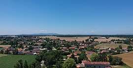 An aerial view of Saint-André-de-Corcy | |
Location of Saint-André-de-Corcy 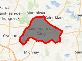
| |
 Saint-André-de-Corcy  Saint-André-de-Corcy | |
| Coordinates: 45°55′38″N 4°57′10″E | |
| Country | France |
| Region | Auvergne-Rhône-Alpes |
| Department | Ain |
| Arrondissement | Bourg-en-Bresse |
| Canton | Villars-les-Dombes |
| Intercommunality | Centre Dombes |
| Government | |
| • Mayor (2008–2014) | Jean-Pierre Baron |
| Area 1 | 20.73 km2 (8.00 sq mi) |
| Population (2017-01-01)[1] | 3,354 |
| • Density | 160/km2 (420/sq mi) |
| Time zone | UTC+01:00 (CET) |
| • Summer (DST) | UTC+02:00 (CEST) |
| INSEE/Postal code | 01333 /01390 |
| Elevation | 279–306 m (915–1,004 ft) (avg. 296 m or 971 ft) |
| 1 French Land Register data, which excludes lakes, ponds, glaciers > 1 km2 (0.386 sq mi or 247 acres) and river estuaries. | |
Population
| Year | Pop. | ±% |
|---|---|---|
| 1962 | 731 | — |
| 1968 | 780 | +6.7% |
| 1975 | 900 | +15.4% |
| 1982 | 2,131 | +136.8% |
| 1990 | 2,547 | +19.5% |
| 1999 | 3,101 | +21.8% |
| 2008 | 2,971 | −4.2% |
| 2009 | 3,007 | +1.2% |
| 2010 | 2,991 | −0.5% |
Sites and monuments
The commune has several châteaux and poypes (fortified mounds, or mottes). The motte castrale Poype Les Roussière has been listed as monument historique by the French Ministry of Culture since 1989.[2] The Château de Montribloud a castle converted to a residence, dates from the 14th century.
gollark: If it does get very good compression ratios why not use it on things *other* than (de)compressing code?
gollark: And I ignore "do not disturb" statii.
gollark: Well, you're on the staff list at the side.
gollark: Suuuuuuuuuuure.
gollark: ... oh no, MORE concurrency bugs.
See also
References
- "Populations légales 2017". INSEE. Retrieved 6 January 2020.
- Ministry of Culture: Saint-André-de-Corcy: Edifice fortifié, dit poype de la Roussière (in French)
| Wikimedia Commons has media related to Saint-André-de-Corcy. |
This article is issued from Wikipedia. The text is licensed under Creative Commons - Attribution - Sharealike. Additional terms may apply for the media files.