Saint-André-de-Bâgé
Saint-André-de-Bâgé is a commune in the Ain department in eastern France.
Saint-André-de-Bâgé | |
|---|---|
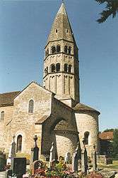 The church in Saint-André-de-Bâgé | |
Location of Saint-André-de-Bâgé 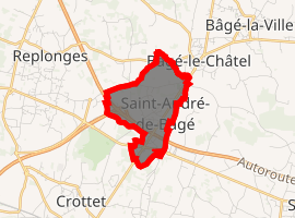
| |
 Saint-André-de-Bâgé  Saint-André-de-Bâgé | |
| Coordinates: 46°18′00″N 4°55′00″E | |
| Country | France |
| Region | Auvergne-Rhône-Alpes |
| Department | Ain |
| Arrondissement | Bourg-en-Bresse |
| Canton | Replonges |
| Intercommunality | Pays de Bâgé |
| Government | |
| • Mayor (2008–2014) | Daniel Clere |
| Area 1 | 2.7 km2 (1.0 sq mi) |
| Population (2017-01-01)[1] | 751 |
| • Density | 280/km2 (720/sq mi) |
| Time zone | UTC+01:00 (CET) |
| • Summer (DST) | UTC+02:00 (CEST) |
| INSEE/Postal code | 01332 /01380 |
| Elevation | 183–212 m (600–696 ft) (avg. 188 m or 617 ft) |
| 1 French Land Register data, which excludes lakes, ponds, glaciers > 1 km2 (0.386 sq mi or 247 acres) and river estuaries. | |
Population
| Year | Pop. | ±% |
|---|---|---|
| 1793 | 156 | — |
| 1800 | 148 | −5.1% |
| 1806 | 151 | +2.0% |
| 1821 | 188 | +24.5% |
| 1831 | 177 | −5.9% |
| 1836 | 200 | +13.0% |
| 1841 | 223 | +11.5% |
| 1846 | 220 | −1.3% |
| 1851 | 218 | −0.9% |
| 1856 | 201 | −7.8% |
| 1861 | 190 | −5.5% |
| 1866 | 187 | −1.6% |
| 1872 | 186 | −0.5% |
| 1876 | 196 | +5.4% |
| 1881 | 197 | +0.5% |
| 1886 | 205 | +4.1% |
| 1891 | 181 | −11.7% |
| 1896 | 174 | −3.9% |
| 1901 | 164 | −5.7% |
| 1906 | 170 | +3.7% |
| 1911 | 163 | −4.1% |
| 1921 | 151 | −7.4% |
| 1926 | 143 | −5.3% |
| 1931 | 136 | −4.9% |
| 1936 | 143 | +5.1% |
| 1946 | 139 | −2.8% |
| 1954 | 141 | +1.4% |
| 1962 | 145 | +2.8% |
| 1968 | 163 | +12.4% |
| 1975 | 257 | +57.7% |
| 1982 | 391 | +52.1% |
| 1990 | 437 | +11.8% |
| 1999 | 507 | +16.0% |
| 2008 | 555 | +9.5% |
gollark: A what?
gollark: It's actually automorphic to a moderately sized bucket of bees.
gollark: Plus, what of people with narrow screens on desktop for whatever reason?
gollark: It's LITERALLY just a giant regex. This is not reliable.
gollark: Wow, this is awful.
See also
References
- "Populations légales 2017". INSEE. Retrieved 6 January 2020.
| Wikimedia Commons has media related to Saint-André-de-Bâgé. |
This article is issued from Wikipedia. The text is licensed under Creative Commons - Attribution - Sharealike. Additional terms may apply for the media files.