Châtillon-la-Palud
Châtillon-la-Palud is a commune in the Ain department in eastern France.
Châtillon-la-Palud | |
|---|---|
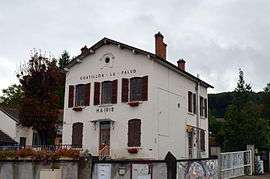 The town hall in Châtillon-la-Palud | |
.svg.png) Coat of arms | |
Location of Châtillon-la-Palud 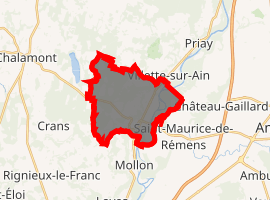
| |
 Châtillon-la-Palud  Châtillon-la-Palud | |
| Coordinates: 45°58′37″N 5°14′59″E | |
| Country | France |
| Region | Auvergne-Rhône-Alpes |
| Department | Ain |
| Arrondissement | Bourg-en-Bresse |
| Canton | Ceyzériat |
| Intercommunality | Dombes |
| Government | |
| • Mayor (2014-2020) | André Michon |
| Area 1 | 14.01 km2 (5.41 sq mi) |
| Population (2017-01-01)[1] | 1,584 |
| • Density | 110/km2 (290/sq mi) |
| Time zone | UTC+01:00 (CET) |
| • Summer (DST) | UTC+02:00 (CEST) |
| INSEE/Postal code | 01092 /01320 |
| Elevation | 218–326 m (715–1,070 ft) |
| 1 French Land Register data, which excludes lakes, ponds, glaciers > 1 km2 (0.386 sq mi or 247 acres) and river estuaries. | |
Geography
The commune is located in the Dombes. It lies on the right bank of the Ain, which flows south through the commune's eastern part. The Albarine flows into the Ain in the southeastern part of the commune.
Population
| Year | Pop. | ±% |
|---|---|---|
| 2004 | 1,336 | — |
| 2006 | 1,395 | +4.4% |
| 2007 | 1,446 | +3.7% |
| 2008 | 1,496 | +3.5% |
| 2009 | 1,546 | +3.3% |
| 2010 | 1,562 | +1.0% |
| 2011 | 1,583 | +1.3% |
| 2012 | 1,578 | −0.3% |
| 2013 | 1,573 | −0.3% |
| 2014 | 1,568 | −0.3% |
| 2015 | 1,566 | −0.1% |
| 2016 | 1,574 | +0.5% |
gollark: So why the giant hole in the one you're standing in?
gollark: Are the powerlines that big?
gollark: What I mean is, on *all* the ones you show, why are they not multi-floor - why is it just a single floor with some balconies above?
gollark: I mean, why is there just a 3-block solid rim round empty space?
gollark: Why the hole in the middle and not solid floor though?
See also
External links
| Wikimedia Commons has media related to Châtillon-la-Palud. |
This article is issued from Wikipedia. The text is licensed under Creative Commons - Attribution - Sharealike. Additional terms may apply for the media files.