Saint-Maurice-la-Souterraine
Saint-Maurice-la-Souterraine is a commune in the Creuse department in central France.
Saint-Maurice-la-Souterraine | |
|---|---|
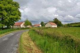 Buildings in Saint-Maurice-la-Souterraine | |
Location of Saint-Maurice-la-Souterraine 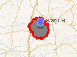
| |
 Saint-Maurice-la-Souterraine  Saint-Maurice-la-Souterraine | |
| Coordinates: 46°12′54″N 1°25′55″E | |
| Country | France |
| Region | Nouvelle-Aquitaine |
| Department | Creuse |
| Arrondissement | Guéret |
| Canton | La Souterraine |
| Intercommunality | CC Pays Sostranien |
| Government | |
| • Mayor (2008–2014) | Gilbert Tixier |
| Area 1 | 39.72 km2 (15.34 sq mi) |
| Population (2017-01-01)[1] | 1,223 |
| • Density | 31/km2 (80/sq mi) |
| Time zone | UTC+01:00 (CET) |
| • Summer (DST) | UTC+02:00 (CEST) |
| INSEE/Postal code | 23219 /23300 |
| Elevation | 300–422 m (984–1,385 ft) (avg. 359 m or 1,178 ft) |
| 1 French Land Register data, which excludes lakes, ponds, glaciers > 1 km2 (0.386 sq mi or 247 acres) and river estuaries. | |
Geography
The river Semme flows west through the commune's southern part.
The river Brame flows west through the commune's northern part.
Population
| Year | Pop. | ±% |
|---|---|---|
| 1962 | 1,183 | — |
| 1968 | 1,246 | +5.3% |
| 1975 | 1,117 | −10.4% |
| 1982 | 1,082 | −3.1% |
| 1990 | 1,089 | +0.6% |
| 1999 | 1,048 | −3.8% |
| 2008 | 1,201 | +14.6% |
gollark: It's a thing which lets things apply velocity to themselves.
gollark: As well as ender modems and such, so you can get full CC computation and GPS and movement.
gollark: See, you can put computers in minecarts, and then put kinetic augments on those.
gollark: If you're making OC drones, consider cartdrones™ instead?
gollark: Also, the only ones I've used have annoyingly high key travel, thus bad.
See also
References
- "Populations légales 2017". INSEE. Retrieved 6 January 2020.
| Wikimedia Commons has media related to Saint-Maurice-la-Souterraine. |
| Authority control |
|
|---|
This article is issued from Wikipedia. The text is licensed under Creative Commons - Attribution - Sharealike. Additional terms may apply for the media files.