Féniers
Féniers is a commune in the Creuse department in the Nouvelle-Aquitaine region in central France.
Féniers | |
|---|---|
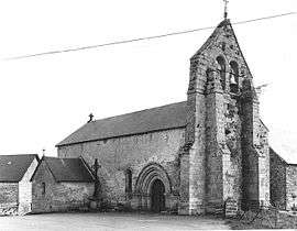 The church in Féniers | |
Location of Féniers 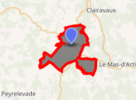
| |
 Féniers  Féniers | |
| Coordinates: 45°45′05″N 2°07′39″E | |
| Country | France |
| Region | Nouvelle-Aquitaine |
| Department | Creuse |
| Arrondissement | Aubusson |
| Canton | Felletin |
| Intercommunality | Haute-Corrèze Communauté |
| Government | |
| • Mayor (2008–2014) | Jean Claude Alarmaguy |
| Area 1 | 14.33 km2 (5.53 sq mi) |
| Population (2017-01-01)[1] | 94 |
| • Density | 6.6/km2 (17/sq mi) |
| Time zone | UTC+01:00 (CET) |
| • Summer (DST) | UTC+02:00 (CEST) |
| INSEE/Postal code | 23080 /23100 |
| Elevation | 772–922 m (2,533–3,025 ft) |
| 1 French Land Register data, which excludes lakes, ponds, glaciers > 1 km2 (0.386 sq mi or 247 acres) and river estuaries. | |
Geography
An area of lakes, forestry and farming, comprising the village and several hamlets situated in the upper valley of the Creuse River, some 15 miles (24 km) south of Aubusson, at the junction of the D31, D26 and the D8 roads.
Population
| Year | Pop. | ±% |
|---|---|---|
| 1962 | 110 | — |
| 1968 | 136 | +23.6% |
| 1975 | 128 | −5.9% |
| 1982 | 110 | −14.1% |
| 1990 | 105 | −4.5% |
| 1999 | 93 | −11.4% |
| 2008 | 86 | −7.5% |
Sights
- The twelfth-century church.
- A menhir.
gollark: Not contemporary GTech™ 512-bit quaternary-quaternionic-posit processors?
gollark: And they will never have more than 48 bits used for addressing.
gollark: This is valid as all devices have x86_64 CPUs, yes.
gollark: You should use 16 HIGH bits as a flag, as my x86 CPUs all appear to only have 48-bit virtual addressing.
gollark: `uintptr_t` you?
See also
References
- "Populations légales 2017". INSEE. Retrieved 6 January 2020.
External links
| Wikimedia Commons has media related to Féniers. |
- Féniers on the Quid website (in French)
| Authority control |
|
|---|
This article is issued from Wikipedia. The text is licensed under Creative Commons - Attribution - Sharealike. Additional terms may apply for the media files.