Viersat
Versat is a commune in the Creuse department in the Nouvelle-Aquitaine region in central France.
Versat | |
|---|---|
.svg.png) Coat of arms | |
Location of Versat 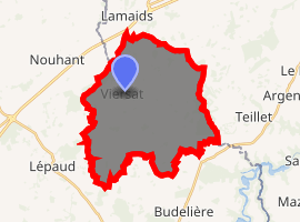
| |
 Versat  Versat | |
| Coordinates: 46°16′17″N 2°25′55″E | |
| Country | France |
| Region | Nouvelle-Aquitaine |
| Department | Creuse |
| Arrondissement | Aubusson |
| Canton | Évaux-les-Bains |
| Intercommunality | CC Creuse Confluence |
| Government | |
| • Mayor (2014–2020) | Nadine Glomeaud |
| Area 1 | 29.09 km2 (11.23 sq mi) |
| Population (2017-01-01)[1] | 303 |
| • Density | 10/km2 (27/sq mi) |
| Time zone | UTC+01:00 (CET) |
| • Summer (DST) | UTC+02:00 (CEST) |
| INSEE/Postal code | 23261 /23170 |
| Elevation | 369–494 m (1,211–1,621 ft) |
| 1 French Land Register data, which excludes lakes, ponds, glaciers > 1 km2 (0.386 sq mi or 247 acres) and river estuaries. | |
Geography
A farming area comprising a village and several hamlets situated some 18 miles (29 km) southwest of Montlucon, at the junction of the D14, D41 and the D64 roads.
Population
| Year | Pop. | ±% |
|---|---|---|
| 1962 | 446 | — |
| 1968 | 464 | +4.0% |
| 1975 | 396 | −14.7% |
| 1982 | 343 | −13.4% |
| 1990 | 378 | +10.2% |
| 1999 | 348 | −7.9% |
| 2008 | 335 | −3.7% |
Sights
- The church, dating from the twelfth century.
- The seventeenth-century château de Chatelguyon.
gollark: It's a giant coordination problem. Coordinating change is difficult and you need to coordinate to do much.
gollark: Anyway, while I don't agree with your views at all, it is interesting to discuss things with someone who thinks very differently, so thanks.
gollark: It is probably an improvement on average, at least.
gollark: The current system, whatever you label it, works fairly well. There are definitely problems. So many problems. Also lots of room for significant improvements without getting rid of it all. But it works decently well without requiring everyone to magically get along fine and the world is steadily increasing in prosperity.
gollark: If your thing only works for self-selected small groups, then it's hardly a good way to organize... our whole global societies comprising 7 billion people, quite a lot of whom don't like each other.
See also
References
- "Populations légales 2017". INSEE. Retrieved 6 January 2020.
External links
- Versat on the Quid website (in French)
| Wikimedia Commons has media related to Viersat. |
| Authority control |
|
|---|
This article is issued from Wikipedia. The text is licensed under Creative Commons - Attribution - Sharealike. Additional terms may apply for the media files.