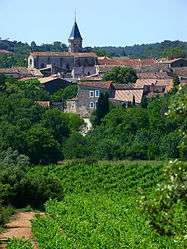
Saint-Drézéry
Saint-Drézéry is a commune in the Hérault department in the Occitanie region in southern France.
Saint-Drézéry | |
|---|---|
 A general view of Saint-Drézéry | |
.svg.png) Coat of arms | |
Location of Saint-Drézéry 
| |
 Saint-Drézéry  Saint-Drézéry | |
| Coordinates: 43°44′03″N 3°58′58″E | |
| Country | France |
| Region | Occitanie |
| Department | Hérault |
| Arrondissement | Montpellier |
| Canton | Le Crès |
| Intercommunality | Montpellier Méditerranée Métropole |
| Government | |
| • Mayor (2008–2014) | Jacqueline Boulbes |
| Area 1 | 10.47 km2 (4.04 sq mi) |
| Population (2017-01-01)[1] | 2,526 |
| • Density | 240/km2 (620/sq mi) |
| Time zone | UTC+01:00 (CET) |
| • Summer (DST) | UTC+02:00 (CEST) |
| INSEE/Postal code | 34249 /34160 |
| Elevation | 60–145 m (197–476 ft) (avg. 86 m or 282 ft) |
| 1 French Land Register data, which excludes lakes, ponds, glaciers > 1 km2 (0.386 sq mi or 247 acres) and river estuaries. | |
Population
| Year | Pop. | ±% |
|---|---|---|
| 1962 | 523 | — |
| 1968 | 555 | +6.1% |
| 1975 | 574 | +3.4% |
| 1982 | 1,017 | +77.2% |
| 1990 | 1,329 | +30.7% |
| 1999 | 1,754 | +32.0% |
| 2008 | 2,117 | +20.7% |
gollark: Hatchlings? When?!
gollark: * partial mintpocalypse
gollark: ```You can see the baby Comrade curled up inside this translucent egg.```
gollark: I should go with a Comrade naming scheme for omens.
gollark: There seems to be.
See also
References
- "Populations légales 2017". INSEE. Retrieved 6 January 2020.
| Wikimedia Commons has media related to Saint-Drézéry. |
This article is issued from Wikipedia. The text is licensed under Creative Commons - Attribution - Sharealike. Additional terms may apply for the media files.