Lauret, Hérault
Lauret is a commune in the Hérault département in the Occitanie region in southern France.

Map
Lauret | |
|---|---|
 Lauret | |
.svg.png) Coat of arms | |
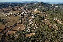
Location of Lauret 
| |
 Lauret  Lauret | |
| Coordinates: 43°50′11″N 3°53′14″E | |
| Country | France |
| Region | Occitanie |
| Department | Hérault |
| Arrondissement | Lodève |
| Canton | Lodève |
| Intercommunality | Orthus |
| Government | |
| • Mayor (2008–2014) | André Leenhardt |
| Area 1 | 6.67 km2 (2.58 sq mi) |
| Population (2017-01-01)[1] | 599 |
| • Density | 90/km2 (230/sq mi) |
| Time zone | UTC+01:00 (CET) |
| • Summer (DST) | UTC+02:00 (CEST) |
| INSEE/Postal code | 34131 /34270 |
| Elevation | 125–400 m (410–1,312 ft) (avg. 160 m or 520 ft) |
| 1 French Land Register data, which excludes lakes, ponds, glaciers > 1 km2 (0.386 sq mi or 247 acres) and river estuaries. | |
Population
| Year | Pop. | ±% |
|---|---|---|
| 1962 | 165 | — |
| 1968 | 166 | +0.6% |
| 1975 | 147 | −11.4% |
| 1982 | 169 | +15.0% |
| 1990 | 224 | +32.5% |
| 1999 | 426 | +90.2% |
| 2008 | 564 | +32.4% |
gollark: You should probably try a simpler step toward whatever your goals are *first*, to see if it's viable or not.
gollark: As far as I know stuff like detecting and tracking objects and generally converting the 2D input from eyes into a 3D worldspace thingy is quite hard, audio is mostly just fourier-transforming.
gollark: The visual system is waaay higher bandwidth and needs much more complex processing to do useful things with.
gollark: I feel like you may be underestimating the complexity of this, and I don't see why you need dedicated hardware to test this idea.
gollark: The traditional 5 ones are somewhat arbitrary.
See also
References
- "Populations légales 2017". INSEE. Retrieved 6 January 2020.
| Wikimedia Commons has media related to Lauret (Hérault). |
| Authority control |
|
|---|
This article is issued from Wikipedia. The text is licensed under Creative Commons - Attribution - Sharealike. Additional terms may apply for the media files.