Loupian
Loupian is a commune in the Hérault département in southern France.

Map
Loupian | |
|---|---|
 Church of Sainte-Cécile | |
.svg.png) Coat of arms | |
Location of Loupian 
| |
 Loupian  Loupian | |
| Coordinates: 43°27′03″N 3°36′52″E | |
| Country | France |
| Region | Occitanie |
| Department | Hérault |
| Arrondissement | Montpellier |
| Canton | Mèze |
| Intercommunality | CA Sète Agglopôle Méditerranée |
| Government | |
| • Mayor (2014–2020) | Alain Vidal |
| Area 1 | 16.00 km2 (6.18 sq mi) |
| Population (2017-01-01)[1] | 2,160 |
| • Density | 140/km2 (350/sq mi) |
| Time zone | UTC+01:00 (CET) |
| • Summer (DST) | UTC+02:00 (CEST) |
| INSEE/Postal code | 34143 /34140 |
| Elevation | 0–170 m (0–558 ft) (avg. 2 m or 6.6 ft) |
| 1 French Land Register data, which excludes lakes, ponds, glaciers > 1 km2 (0.386 sq mi or 247 acres) and river estuaries. | |
Population
| Year | Pop. | ±% |
|---|---|---|
| 1962 | 871 | — |
| 1968 | 901 | +3.4% |
| 1975 | 934 | +3.7% |
| 1982 | 1,113 | +19.2% |
| 1990 | 1,289 | +15.8% |
| 1999 | 1,483 | +15.1% |
| 2008 | 2,085 | +40.6% |
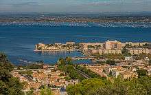
Loupian and the Étang de Thau from Sète.

"Saint-Félix" and the Étang de Thau.
gollark: Consider the "rich" function. If you consider the arguments there, and its name, you might be able to guess "oh, maybe that gets the richest users", but you may get it wrong and end up annoyed.
gollark: Stuff isn't particularly self-descriptive a lot of the time. Not as much as comments and stuff make it.
gollark: Combined with the example code, it's usable, but vaguely annoying.
gollark: It briefly describes jua, mentions the available non-websocket API calls, then has a short websocket-y code example which seems to miss a few important features.
gollark: The build process would be a bit annoying, though.
References
- "Populations légales 2017". INSEE. Retrieved 6 January 2020.
| Wikimedia Commons has media related to Loupian. |
| Authority control |
|
|---|
This article is issued from Wikipedia. The text is licensed under Creative Commons - Attribution - Sharealike. Additional terms may apply for the media files.