Galargues
Galargues is a commune in the Hérault département in Occitanie in southern France.
Map
Galargues | |
|---|---|
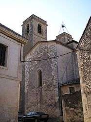 The church of Notre-Dame-de-l'Assomption | |
 Coat of arms | |
Location of Galargues 
| |
 Galargues  Galargues | |
| Coordinates: 43°46′17″N 4°01′19″E | |
| Country | France |
| Region | Occitanie |
| Department | Hérault |
| Arrondissement | Montpellier |
| Canton | Lunel |
| Intercommunality | Ceps et Sylves |
| Government | |
| • Mayor (2008–2014) | Jean-Marie Hurtemel |
| Area 1 | 11.43 km2 (4.41 sq mi) |
| Population (2017-01-01)[1] | 725 |
| • Density | 63/km2 (160/sq mi) |
| Time zone | UTC+01:00 (CET) |
| • Summer (DST) | UTC+02:00 (CEST) |
| INSEE/Postal code | 34110 /34160 |
| Elevation | 29–257 m (95–843 ft) (avg. 54 m or 177 ft) |
| 1 French Land Register data, which excludes lakes, ponds, glaciers > 1 km2 (0.386 sq mi or 247 acres) and river estuaries. | |
Population
| Year | Pop. | ±% |
|---|---|---|
| 1962 | 265 | — |
| 1968 | 279 | +5.3% |
| 1975 | 253 | −9.3% |
| 1982 | 342 | +35.2% |
| 1990 | 404 | +18.1% |
| 1999 | 519 | +28.5% |
| 2008 | 629 | +21.2% |
gollark: More ellipses → more security. This is known.
gollark: PotatOS is highly "secured" because it has two separate elliptic curve cryptography things in it.
gollark: .
gollark: I'm not, blame "Dimaguy"
gollark: It protects you against the case where someone can somehow *read* your network traffic but not *alter* it, maybe. But that's not really worth lots of (rather horrible) code, probable insecurity, and extra complexity.
See also
References
- "Populations légales 2017". INSEE. Retrieved 6 January 2020.
| Wikimedia Commons has media related to Galargues. |
| Authority control |
|
|---|
This article is issued from Wikipedia. The text is licensed under Creative Commons - Attribution - Sharealike. Additional terms may apply for the media files.