Quebec Route 370
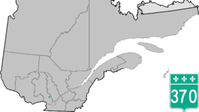
Route 370 is a short provincial highway located in the Laurentides region of Quebec. The 11-kilometer highway which starts at the junctions of Autoroute 15 and Route 117 links the towns of Sainte-Adele and Esterel, two major touristic destinations in the region.
| ||||
|---|---|---|---|---|
 | ||||
| Route information | ||||
| Maintained by Transports Québec | ||||
| Length | 11.0 km[1] (6.8 mi) | |||
| Major junctions | ||||
| West end | ||||
| East end | Chemin Masson in Sainte-Marguerite-du-Lac-Masson | |||
| Location | ||||
| Major cities | Sainte-Adele | |||
| Highway system | ||||
| ||||

Towns located along Route 370
Major intersections
The entire route is in Les Pays-d'en-Haut RCM.
| Location | km | mi | Destinations | Notes | |
|---|---|---|---|---|---|
| Sainte-Adèle | 0 | 0.0 | Western terminus | ||
| Exit 69 (A-15) | |||||
| Sainte-Marguerite-du-Lac-Masson | 11 | 6.8 | Chemin Masson | Eastern terminus | |
| 1.000 mi = 1.609 km; 1.000 km = 0.621 mi | |||||
gollark: I definitely won't construct 86 quintillion simulations of your scanned neural patterns undergoing a thousand years of torture.
gollark: How am I meant to do *that*?
gollark: > howThis is left as an exercise to the reader.> and whySo I can buy GPUs.
gollark: Attain it.
gollark: You disagree with our ethics machines?
See also
References
- Ministère des transports, "Distances routières", page (?), Les Publications du Québec, 2005
- Sources
- Official Map of Transports Quebec (in French)
- Route 370 on Google Maps
This article is issued from Wikipedia. The text is licensed under Creative Commons - Attribution - Sharealike. Additional terms may apply for the media files.