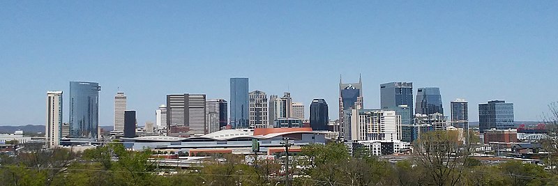
Nashville metropolitan area
The Nashville metropolitan area (officially, the Nashville-Davidson–Murfreesboro–Franklin, TN Metropolitan Statistical Area) is centered on Nashville, Tennessee, in the United States. It includes 13 counties in Middle Tennessee, reduced from 14 in September 2018 when Hickman County was removed.[1]
The Mid-State | |
|---|---|
| Nashville-Davidson-Mufreesboro-Franklin, TN MSA | |
 Nashville skyline | |
 Nashville-Davidson-Mufreesboro-Franklin Metropolitan Statistical Area | |
| Country | |
| State | |
| Largest city | |
| Principal cities | - Murfreesboro - Franklin |
| Area | |
| • Total | 7,484 sq mi (19,380 km2) |
| Population (2019 est.) | |
| • Total | 2,090,958 (36th) |
| • Density | 258/sq mi (100/km2) |
| Time zone | UTC−6 (Central Time Zone (CST)) |
| • Summer (DST) | UTC−5 (CDT) |
| Area code(s) | 615, 629 |
| Website | www |
The Office of Management and Budget's defines the metro area for statistical use by the United States Census Bureau and other agencies. The area is the 36th largest MSA in the United States[2] and is the largest metropolitan area in the state of Tennessee.
The metropolitan statistical area was first designated in 1950 and initially included only Davidson County. As surrounding counties increased in population and population densities and in the number of their residents employed in Davidson County, the OMB added new counties to the MSA. Today, the metro area includes Davidson and 12 other counties.
Cities and towns
Anchor city
Principal cities or communities with over 75,000 inhabitants
Satellite cities or communities with more than 50,000 inhabitants
Suburbs with 25,000 to 50,000 inhabitants
Suburbs with 10,000 to 25,000 inhabitants
Suburbs with 1,000 to 10,000 inhabitants
- Ashland City
- Belle Meade
- Bethpage
- Burns
- Carthage
- Charlotte
- Coopertown
- Cross Plains
- Fairview
- Forest Hills
- Gordonsville
- Greenbrier
- Green Hill (CDP)
- Hartsville
- Kingston Springs
- Lafayette
- Lakewood
- Millersville
- Mount Pleasant
- Oak Hill
- Pegram
- Pleasant View
- Red Boiling Springs
- Ridgetop
- Rural Hill (CDP)
- South Carthage
- Thompson's Station
- Watertown
- Westmoreland
- White Bluff
- Woodbury
Suburbs with fewer than 1,000 inhabitants
- Adams
- Auburntown
- Berry Hill
- Cedar Hill
- Eagleville
- Mitchellville
- Orlinda
- Slayden
- Vanleer
- Walterhill (CDP)
Metropolitan area statistics
| Geographic Area | July 1, 2019[3] | 2010 Census | 2000 Census | 1990 Census | 1980 Census | 1970 Census | 1960 Census | 1950 Census |
|---|---|---|---|---|---|---|---|---|
| Nashville-Davidson–Murfreesboro–Franklin | 1,959,495 | 1,589,934 | 1,311,789 | 985,026 | 850,505 | 541,108 | 399,743 | 321,758 |
| Cannon County | 14,678 | 13,801 | 12,826 | 10,467* | 10,234* | 8,467* | 8,537* | 9,174* |
| Cheatham County | 40,667 | 39,105 | 35,912 | 27,140 | 21,616 | 13,199* | 9,428* | 9,167* |
| Davidson County | 694,144 | 626,681 | 569,891 | 510,784 | 477,811 | 448,003 | 399,743 | 321,758 |
| Dickson County | 53,948 | 49,666 | 43,156 | 35,061 | 30,037 | 21,977* | 18,839* | 18,805* |
| Hickman County | 25,178 | 24,690 | 22,295 | 16,754* | 15,151* | 12,096* | 11,862* | 13,353* |
| Macon County | 24,602 | 22,248 | 20,386 | 15,906* | 15,700* | 12,315* | 12,197* | 13,599* |
| Maury County | 96,387 | 80,956* | 69,498* | 54,812* | 51,095* | 43,376* | 41,699* | 40,368* |
| Robertson County | 71,813 | 66,283 | 54,433 | 41,494 | 37,021 | 29,102* | 27,335* | 27,024* |
| Rutherford County | 332,285 | 262,604 | 182,023 | 118,570 | 84,058 | 59,428* | 52,368* | 40,696* |
| Smith County | 20,157 | 19,166 | 17,712 | 14,143* | 14,935* | 12,509* | 12,059* | 14,098* |
| Sumner County | 191,283 | 160,634 | 130,449 | 103,281 | 85,790 | 56,106 | 36,217* | 33,533* |
| Trousdale County | 11,284 | 7,864 | 7,259 | 5,920* | 6,137* | 5,155* | 4,914* | 5,520* |
| Williamson County | 238,412 | 183,182 | 126,638 | 81,021 | 58,108 | 34,330* | 25,267* | 24,307* |
| Wilson County | 144,657 | 113,993 | 88,809 | 67,675 | 56,064 | 36,999 | 27,668* | 26,318* |
* County was not a part of this statistical area at the time of this Census and the county's population is not included in the total.
Combined Statistical Area
The Nashville-Davidson–Murfreesboro, TN, Combined Statistical Area (CSA) is the result of the addition of the Micropolitan Statistical Areas of Shelbyville (Bedford County), Lawrenceburg (Lawrence County) and Lewisburg (Marshall County) to the Nashville-Davidson–Murfreesboro–Franklin, TN, Metropolitan Statistical Area. The estimated population of the CSA as of July 1, 2019, was 2,087,725.[3]
References
- "Office of Management and Budget" (PDF).
- "Annual Estimates of the Population of Metropolitan and Micropolitan Statistical Areas: April 1, 2010 to July 1, 2012 (CBSA-EST2012-01)". Archived from the original on April 1, 2013.
- Bureau, U.S. Census. "County Population Totals and Components of Change: 2010-2018". www.census.gov/.
External links
- February 2013 delineations of metropolitan and combined statistical areas
- U.S. Census Bureau State & County QuickFacts
- U.S. Census Bureau population estimates
- Metropolitan and Micropolitan Statistical Areas
- About Metropolitan and Micropolitan Statistical Areas
- Historical Metropolitan Area Definitions
