Grade II* listed buildings in Weymouth and Portland
There are over 20,000 Grade II* listed buildings in England. This page is a list of these buildings in the district of Weymouth and Portland in the county of Dorset.
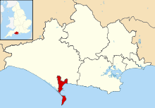
Weymouth and Portland shown in Dorset
Buildings
| Name | Location | Type | Completed [note 1] | Date designated | Grid ref.[note 2] Geo-coordinates |
Entry number [note 3] | Image |
|---|---|---|---|---|---|---|---|
| Captain's House | Castletown, Portland | House | Between 1816 and 1835 | 17 May 1993 | SY6843574359 50°34′05″N 2°26′49″W |
1280817 |  |
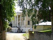
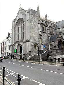
| Church of St Peter | The Grove, Portland | Anglican church | 1872 | 21 September 1978 | SY6988972581 50°33′08″N 2°25′35″W |
1205607 | 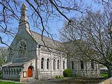 Church of St Peter |
| Easton Methodist Church with Former Manse and Boundary Walls | Easton, Portland | Methodist church and manse | 1906 | 17 May 1993 | SY6911271845 50°32′44″N 2°26′14″W |
1280713 | 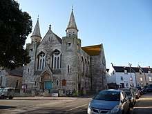 Easton Methodist Church with Former Manse and Boundary Walls |
| Gateway and Curtain Wall to South East of Captain's House | Castletown, Portland | Gateway | Mid 16th century | 17 May 1993 | SY6844774341 50°34′05″N 2°26′49″W |
1205280 | |
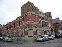
| Grove County Primary School with Rear Boundary Wall | The Grove, Portland | School | Opened 1872 | 21 September 1978 | SY6995472555 50°33′07″N 2°25′32″W |
1205631 | 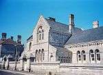 Grove County Primary School with Rear Boundary Wall |
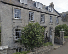
| Queen Anne House with Boundary Wall and Gate Piers | Fortuneswell, Portland | House | Early 18th century | 17 May 1993 | SY6892073298 50°33′31″N 2°26′24″W |
1203085 | |
| Ruins of Church of St Andrew | Easton, Portland | Anglican church | 14th century | 16 January 1951 | SY6967971106 50°32′20″N 2°25′45″W |
1205384 | |
| The Citadel, North Entrance | Portland | Arch and tunnel | 1880 | 17 May 1993 | SY6906273874 50°33′50″N 2°26′17″W |
1206120 | 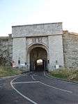 The Citadel, North Entrance |
| The Citadel, South Entrance | Portland | Gatehouse | 1881 | 17 May 1993 | SY6933373418 50°33′35″N 2°26′03″W |
1203116 | 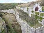 The Citadel, South Entrance |
| The Citadel, South West and South East Casemates | Portland | Casemates | c. 1860 | 17 May 1993 | SY6923873547 50°33′39″N 2°26′08″W |
1203117 | |
| Belfield House | Weymouth | Country house | c. 1775 | 12 December 1953 | SY6675677885 50°35′59″N 2°28′16″W |
1313440 | |
| Black Dog Public House | Weymouth | Inn | 17th century | 18 June 1970 | SY6799479138 50°36′40″N 2°27′13″W |
1132631 | 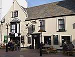 Black Dog Public House |
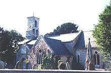
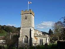
| Church of St Andrew | Preston, Weymouth | Anglican church | 16th century, restored 1855 | 12 December 1953 | SY7058182968 50°38′44″N 2°25′03″W |
1135140 | 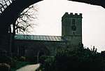 Church of St Andrew |
| Church of St Ann | Radipole, Weymouth | Anglican church | 14th century, 19th-century restoration | 12 December 1953 | SY6672481370 50°37′52″N 2°28′19″W |
1096727 | |
| Church of St John the Evangelist | Weymouth | Anglican church | 1854 | 12 December 1953 | SY6823080058 50°37′10″N 2°27′02″W |
1272142 | |
| Church of St Laurence | Upwey, Weymouth | Anglican church | Late 15th century, 19th-century restoration | 12 December 1953 | SY6605685241 50°39′57″N 2°28′54″W |
1272096 | |
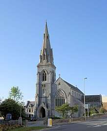
| Church of the Holy Trinity | Weymouth | Anglican church | 1888 | 12 December 1953 | SY6785778650 50°36′24″N 2°27′20″W |
1148099 | |
| Devonshire Buildings (terrace) | Weymouth | House | c. 1805 – 1819 with 20th-century additions | 12 December 1953 | SY6824578836 50°36′30″N 2°27′00″W |
1145964 | 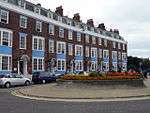 Devonshire Buildings (terrace) |
| Gloucester Lodge with the Cork and Bottle Public House | Weymouth | Apartments and public house | c. 1780, extended c. 1850 | 12 December 1953 | SY6800179373 50°36′47″N 2°27′13″W |
1038271 | 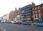 Gloucester Lodge with the Cork and Bottle Public House |
| Guildhall with Attached Rear Boundary Wall | Weymouth | Guildhall | 1836–37, with late 20th-century modifications | 12 December 1953 | SY6794378756 50°36′27″N 2°27′16″W |
1132630 | 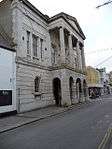 Guildhall with Attached Rear Boundary Wall |
| Maiden Street Methodist Church | Weymouth | Methodist church | 1866–1870 | 2 September 1996 | SY6799378757 50°36′28″N 2°27′13″W |
1142294 | |
| Malthouse Number 4 | Weymouth | Malt house | 1889 | 25 September 1990 | SY6812278485 50°36′19″N 2°27′07″W |
1148063 | 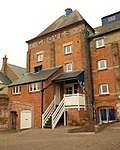 Malthouse Number 4 |
| Netherton Nursing Home | Weymouth | House | Mid 18th century | 12 December 1953 | SY6750978600 50°36′22″N 2°27′38″W |
1132601 | 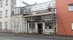 Netherton Nursing Home |
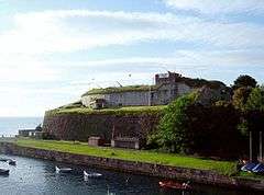
| Nothe Fort and Outer Gateway | Nothe Gardens, Weymouth | Coastal fort | c. 1860 – 1872 | 14 June 1974 | SY6870678735 50°36′27″N 2°26′37″W |
1313430 | |
| Numbers 1-12 with Railings, Waterloo Place | Weymouth | Terrace | c. 1835 | 12 December 1953 | SY6816679912 50°37′05″N 2°27′05″W |
1147976 | |
| Pulteney Buildings (terrace) | Weymouth | House | c. 1805 | 12 December 1953 | SY6819478823 50°36′30″N 2°27′03″W |
1145965 | 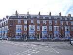 Pulteney Buildings (terrace) |
| Radipole Old Manor | Radipole, Weymouth | Manor house | Late 16th century | 12 December 1953 | SY6674081381 50°37′52″N 2°28′18″W |
1271639 | |
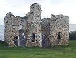
| Sandsfoot Castle Remains | Weymouth | Device Fort | c. 1541 | 12 December 1953 | SY6748277372 50°35′43″N 2°27′39″W |
1096763 | |
| Statue House, Johnstone Row (terrace) | Weymouth | House | c. 1815 | 12 December 1953 | SY6800579202 50°36′42″N 2°27′13″W |
1038260 | 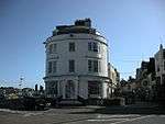 Statue House, Johnstone Row (terrace) |
| The White Hart Public House | Weymouth | Hotel | Early 17th century | 12 December 1953 | SY6786979006 50°36′36″N 2°27′20″W |
1147950 | 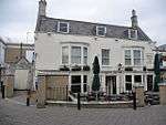 The White Hart Public House |
| Upwey Manor | Upwey, Weymouth | Manor house | 1639 | 12 December 1953 | SY6667884261 50°39′25″N 2°28′22″W |
1148066 | 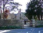 Upwey Manor |
| Upwey Mill | Upwey, Weymouth | Corn mill | 1802 | 12 December 1953 | SY6625085076 50°39′52″N 2°28′44″W |
1272205 | 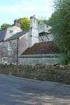 Upwey Mill |
| Westbrook House | Upwey, Weymouth | Country house | 1620, extended c. 1740 – 1750 | 12 December 1953 | SY6659484364 50°39′29″N 2°28′26″W |
1272208 | |
gollark: It's about the right size.
gollark: No it's not.
gollark: Here is our computer factory.
gollark: It's for a project on CodersNet to provide cheap computers to all! GTech partnered with "Microsoft".
gollark: No, it's actually just potatOS with the display settings tweaked slightly.
See also
Notes
- The date given is the date used by Historic England as significant for the initial building or that of an important part in the structure's description.
- Sometimes known as OSGB36, the grid reference is based on the British national grid reference system used by the Ordnance Survey.
- The "List Entry Number" is a unique number assigned to each listed building and scheduled monument by Historic England.
External links
![]()
This article is issued from Wikipedia. The text is licensed under Creative Commons - Attribution - Sharealike. Additional terms may apply for the media files.