Grade II* listed buildings in Poole (borough)
There are over 20,000 Grade II* listed buildings in England. This page is a list of these buildings in the borough of Poole in Dorset.
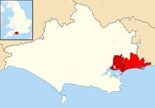
Poole shown in Dorset
Poole
| Name | Location | Type | Completed [note 1] | Date designated | Grid ref.[note 2] Geo-coordinates |
Entry number [note 3] | Image |
|---|---|---|---|---|---|---|---|
| Beech Hurst and Attached Rear Area Railings | Poole | House | 1798 | 14 June 1954 | SZ0133190801 50°43′01″N 1°58′57″W |
1223864 | 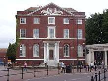 Beech Hurst and Attached Rear Area Railings |
| Church of St James | Poole | Parish church | 1819–21 | 14 June 1954 | SZ0084190438 50°42′49″N 1°59′22″W |
1217470 | |
| Church of St Osmund | Parkstone | Church | 1927 | 30 June 1980 | SZ0443191647 50°43′28″N 1°56′19″W |
1273602 | 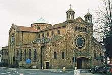 Church of St Osmund |
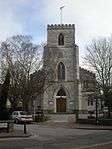
| Church of St Peter | Parkstone | Church | 1900–01 | 14 June 1954 | SZ0340491675 50°43′29″N 1°57′11″W |
1224865 | 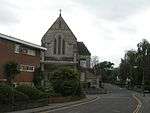 Church of St Peter |
| Custom House | Poole | Custom house | 1781 | 14 June 1954 | SZ0087290296 50°42′44″N 1°59′20″W |
1275358 | |
| Hotel Du Vin and Attached Front Area Wall and Railings | Poole | House | Second half of 18th century | 14 June 1954 | SZ0079790366 50°42′47″N 1°59′24″W |
1225272 | 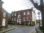 Hotel Du Vin and Attached Front Area Wall and Railings |
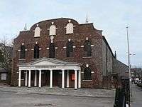
| Kinges Halle | Poole | Warehouse | 15th century | 14 June 1954 | SZ0084090308 50°42′45″N 1°59′22″W |
1275357 |  |
| Parish Church of St Aldhelm | Poole | Parish church | 1911 | 14 June 1954 | SZ0584691800 50°43′33″N 1°55′07″W |
1266563 | 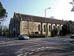 Parish Church of St Aldhelm |
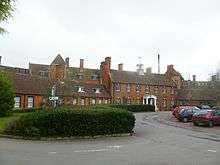
| St Anne's Hospital | Canford Cliffs | Hospital | 1909–12 | 5 October 1988 | SZ0524288784 50°41′55″N 1°55′38″W |
1267416 | |
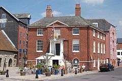
| The Guildhall | Poole | Guildhall | 1761 | 14 June 1954 | SZ0100090562 50°42′53″N 1°59′14″W |
1266739 | 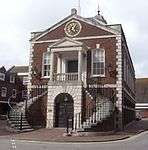 The Guildhall |
| The Old Rectory | Hamworthy | Manor house | c. 1650 | 14 June 1954 | SY9983290586 50°42′54″N 2°00′13″W |
1275403 | |
| United Reformed Church and Attached Wall and Railings to North East | Poole | Church | c. 1777 | 14 June 1954 | SZ0124790444 50°42′49″N 1°59′01″W |
1275356 | |
| Upton House | Upton | Country house | Early 19th century | 8 August 1972 | SY9931092991 50°44′12″N 2°00′40″W |
1225477 | 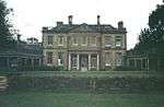 Upton House |
| West End House and Attached Front Garden Railings and Gate | Poole | Merchant's house | Mid 18th century | 14 June 1954 | SZ0077490438 50°42′49″N 1°59′25″W |
1217517 | 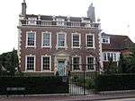 West End House and Attached Front Garden Railings and Gate |
| 73 High Street | Poole | House | Early 16th century | 30 June 1980 | SZ0111390522 50°42′52″N 1°59′08″W |
1217483 | |
| 12 and 14 High Street | Poole | House | Late 16th to early 17th century | 28 March 1974 | SZ0094090389 50°42′47″N 1°59′17″W |
1275413 | |
| 20 Market Street | Poole | Town house | Mid 18th century | 14 June 1954 | SZ0095790531 50°42′52″N 1°59′16″W |
1275386 | |
gollark: Anyway, yes, just don't share your password?
gollark: > I mean none of the accounts are based on my IP anyway... what?
gollark: Well, with Python AND SOME ACTUAL KNOWLEDGE, yes.
gollark: An actual 10 year old probably can't program competently and would download someone else's script to do it.
gollark: And they require some amount of skill too, inasmuch as you won't be typing in every password it by hand.
See also
Notes
- The date given is the date used by Historic England as significant for the initial building or that of an important part in the structure's description.
- Sometimes known as OSGB36, the grid reference is based on the British national grid reference system used by the Ordnance Survey.
- The "List Entry Number" is a unique number assigned to each listed building and scheduled monument by Historic England.
External links
![]()
This article is issued from Wikipedia. The text is licensed under Creative Commons - Attribution - Sharealike. Additional terms may apply for the media files.