D29 road (Croatia)
D29 is a state road in the northwestern Croatia connecting Novi Golubovec and the D35 state road to Soblinec on the D3 state road[maps 1] near the A4 motorway Popovec interchange.[1] The road is 49.8 km (30.9 mi) long.[2]
| |
|---|---|
| Route information | |
| Length | 49.8 km (30.9 mi) |
| Major junctions | |
| From | |
| To | |
| Location | |
| Counties | Krapina-Zagorje, City of Zagreb |
| Major cities | Zlatar, Marija Bistrica |
| Highway system | |
| State roads in Croatia | |
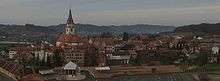
Marija Bistrica, on the D29 road route
The road, as well as all other state roads in Croatia, is managed and maintained by Hrvatske ceste, state owned company.[3]
Traffic volume
Traffic is regularly counted and reported by Hrvatske ceste, operator of the road.[4]
| D29 traffic volume | ||||
| Road | Counting site | AADT | ASDT | Notes |
| 1232 Mače - east | 3,147 | 3,217 | Between the Ž2168 and Ž2128 junctions. | |
| 1231 Zlatar Bistrica | 3,163 | 3,501 | Between the D24 and Ž2202 junctions. | |
| 2004 Kašina | 2,198 | 2,331 | Adjacent to the Ž1001 junction. | |
Road junctions and populated areas
| D29 junctions/populated areas | |
| Type | Slip roads/Notes |
| Novi Golubovec The northern terminus of the road. | |
| Ž2127 to Gora Veternička. | |
| Ž2126 to Gregurovec and Mihovljan. | |
| Ž2128 to Lobor and Ladislavec. | |
| Velika Petrovagorska | |
| Peršaves | |
| Ž2125 to Sutinske Toplice and Mihovljan. | |
| Mače Ž2168 to Mali Bukovec and Poznanovec (D24). | |
| Cetinovec Ž2128 to Ladislavec and Lobor. | |
| Zlatar Ž2169 to Gornja Batina and Budinšćina (D24). | |
| Zlatar Bistrica | |
| Tugonica Ž2202 to Podgrađe. | |
| Marija Bistrica Ž2221 to Donje Orešje and Hrastje (D3). Ž2227 to Podgorje Bistričko. | |
| Ž1006 to Adamovec. | |
| Laz Bistrički | |
| Laz Stubički | |
| Ž2224 to Sveti Matej and Gornja Stubica. | |
| Kašina | |
| Prepuštovec | |
| Vurnovec | |
| Gajec | |
| Soblinec The southern terminus of the road. | |
Maps
- Overview map of the D29 (Map). OpenStreetMap. Retrieved July 22, 2014.
Sources
- "Regulation on motorway markings, chainage, interchange/exit/rest area numbers and names". Narodne novine (in Croatian). April 24, 2003. Archived from the original on October 4, 2011. Retrieved August 10, 2010.
- Ministry of Sea, Transport and Infrastructure (Croatia) (June 4, 2013). "Decision on categorization of public roads" (in Croatian). Narodne novine. Retrieved July 22, 2014.
- "Public Roads Act". Narodne novine (in Croatian). December 14, 2004.
- "Traffic counting on the roadways of Croatia in 2013 - digest" (PDF). Hrvatske ceste. May 2014. Archived from the original (PDF) on 2014-07-29. Retrieved 2014-07-22.
gollark: I agree.
gollark: ... "animals"?
gollark: ```Greetings, esolangs server members. I am gollark, otherwise known as osmarks, a human. As someone who is totally a human, I exist, and do human things such as (not limited to):- consuming food- consuming water- sleeping- not sleeping- sitting in chairs- motionI enjoy things such as esoteric language creation (intermittently), authorship of highly accursed code in a wide range of programming languages, computational gaming, reading scifi/fantasy, and sometimes (when I am not horribly distracted) reading about maths things.```
gollark: Yes, it seems a reasonable idea.
gollark: Oh no. I need to retroactively erase all evidence.
This article is issued from Wikipedia. The text is licensed under Creative Commons - Attribution - Sharealike. Additional terms may apply for the media files.