D213 road
D213 is a state road in Slavonia region of Croatia connecting Dalj and nearby Erdut border crossing to Serbia to D2 state road east of Osijek. The road is 26.7 km (16.6 mi) long.[1]
| |
|---|---|
| Route information | |
| Length | 26.7 km (16.6 mi) |
| Major junctions | |
| From | |
| To | |
| Location | |
| Counties | Osijek-Baranja |
| Major cities | Dalj |
| Highway system | |
| State roads in Croatia | |

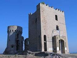
Erdut Castle, in vicinity of the D213 road

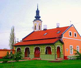
Eparchy of Osječko polje and Baranja in vicinity of the D213 road
The road, as well as all other state roads in Croatia, is managed and maintained by Hrvatske ceste, state owned company.[2]
Traffic volume
Traffic is regularly counted and reported by Hrvatske ceste, operator of the road.[3]
| D213 traffic volume | ||||
| Road | Counting site | AADT | ASDT | Notes |
| 2511 Bijelo Brdo | 3,500 | 4,246 | Adjacent to the L44084 junction. The AADT figure is an estimate by Hrvatske ceste. | |
| 2601 Erdut | 1,647 | 1,911 | Adjacent to the D519 junction. | |
Road junctions and populated areas
| D213 junctions/populated areas | |
| Type | Slip roads/Notes |
The western terminus of the road. | |
| Ž4068 to Nemetin and Osijek. | |
| Sarvaš | |
| Bijelo Brdo L44084 to Bijelo Brdo railway station (within the village). | |
| Ž4093 to Erdut. | |
| Erdut Ž4093 to the town centre. The Ž4093 loops back to the D213 forming another intersection with the latter west of Erdut. | |
| Erdut border crossing to Serbia.[4] The eastern terminus of the road. | |
Sources
- "Decision on categorization of public roads as state roads, county roads and local roads". Narodne novine (in Croatian). February 17, 2010.
- "Public Roads Act". Narodne novine (in Croatian). December 14, 2004.
- "Traffic counting on the roadways of Croatia in 2009 - digest" (PDF). Hrvatske ceste. May 1, 2010. Archived from the original (PDF) on July 21, 2011.
- "Map of border crossings and customs office areas" (PDF). Customs Administration of the Republic of Croatia (in Croatian). March 6, 2008.
gollark: Well, the package manager is quite simple, but the service manager (openrc) is quite different from systemd.
gollark: https://www.alpinelinux.org/ is very small.
gollark: I have probably less than 100GB of actually-useful data which needs storing, so meh.
gollark: Hello, people!
gollark: https://www.ebay.co.uk/itm/333001726025 ← worth bidding on?
This article is issued from Wikipedia. The text is licensed under Creative Commons - Attribution - Sharealike. Additional terms may apply for the media files.
