D119 road
D119 is the main state road on island of Lastovo in Croatia connecting towns of Ubli and Lastovo to a ferry port in Lastovo, from where Jadrolinija ferries fly to the mainland, docking in Split and the D410 state road.[1] The road is 9.5 km (5.9 mi) long.[2]
| |
|---|---|
| Route information | |
| Length | 9.5 km (5.9 mi) |
| Major junctions | |
| From | |
| To | Ubli |
| Location | |
| Counties | Dubrovnik-Neretva |
| Major cities | Lastovo |
| Highway system | |
| State roads in Croatia | |

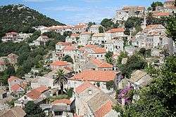
Lastovo, at the eastern terminus the D119 road
The road, as well as all other state roads in Croatia, is managed and maintained by Hrvatske ceste, a state-owned company.[3]
Road junctions and populated areas
| D119 junctions/populated areas | |
| Type | Slip roads/Notes |
| Lastovo ferry port – access to the mainland port of Split (by Jadrolinija)[1] and D410 to Split and A1 motorway Dugopolje interchange.[4] The eastern terminus of the road. | |
| Lastovo L69035 to Skrivena Luka. L69064 to Lučica. | |
| L69034 to Zaklopatica. | |
| Ubli Ž6230 to Pasadur. The western terminus of the road. | |
Sources
- "Jadrolinija ferry service". May 11, 2010.
- "Decision on categorization of public roads as state roads, county roads and local roads". Narodne novine (in Croatian). February 17, 2010.
- "Public Roads Act". Narodne novine (in Croatian). December 14, 2004.
- "Regulation on motorway markings, chainage, interchange/exit/rest area numbers and names". Narodne novine (in Croatian). May 6, 2003.
gollark: <@331320482047721472> What do you want to store your site on? Main server or VPS?
gollark: The HNode™ is nonexistent temporarily. I can give you access to an account on another server.
gollark: Okay, done.
gollark: ++remind 1h web archive
gollark: Oh, web archive, good idea.
This article is issued from Wikipedia. The text is licensed under Creative Commons - Attribution - Sharealike. Additional terms may apply for the media files.