Buffalo Grove, Illinois
Buffalo Grove is a village in Lake and Cook counties in the U.S. state of Illinois, within the northwest suburbs of Chicago.
Buffalo Grove, Illinois | |
|---|---|
Village | |
| The Village of Buffalo Grove, Illinois | |
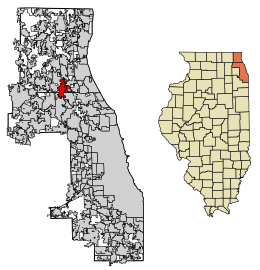
 Location of Buffalo Grove in Lake and Cook Counties, Illinois. | |
.svg.png) Location of Illinois in the United States | |
| Coordinates: 42°9′59″N 87°57′48″W | |
| Country | |
| State | Illinois |
| County | Lake and Cook |
| Townships | Vernon and Wheeling |
| Incorporated | 1958 |
| Government | |
| • Type | Council–manager |
| • President | Beverly Sussman |
| Area | |
| • Total | 9.58 sq mi (24.82 km2) |
| • Land | 9.57 sq mi (24.78 km2) |
| • Water | 0.02 sq mi (0.04 km2) 0.31% |
| Population (2010) | |
| • Total | 41,496 |
| • Estimate (2019)[2] | 40,494 |
| • Density | 4,232.23/sq mi (1,634.05/km2) |
| Standard of living (2009-11) | |
| • Per capita income | $44,067 |
| • Median home value | $313,400 |
| ZIP code(s) | 60089 |
| Area code(s) | 847 and 224 |
| Geocode | 17-09447 |
| FIPS code | 17-09447 |
| Website | www |
| Demographics (2010)[3] | |||
|---|---|---|---|
| White | Black | Asian | |
| 79.8% | 1.0% | 16.0% | |
| Islander | Native | Other | Hispanic (any race) |
| 0.04% | 0.2% | 3.0% | 4.9% |
As of the 2010 census, the village population was 41,496.[4] Most of the village is located within the 10th Congressional District of Illinois, although the southern portion is represented in the 8th Congressional District.
Geography
Buffalo Grove is located at 42°9′59″N 87°57′48″W (42.166332, −87.963391),[5] among the northwest suburbs of Chicago. Illinois Route 83 leads north towards central Lake County and south towards O'Hare International Airport. East-west streets can take residents east to Lake Michigan and other North Shore suburbs such as Lake Forest, Highland Park, and Glencoe.
Buffalo Grove is about 30 miles (48 km) northwest of the Chicago Loop.[6]
Buffalo Grove is split along Lake Cook Road into two parts: the Lake County Vernon Township portion; and the Cook County Wheeling Township portion. Around three-quarters of the village is in Vernon Township. Both portions differ in their demographics and similarities with neighboring communities. Buffalo Grove shares a border with Wheeling to its southeast, Arlington Heights to its southwest and south, Riverwoods and Deerfield directly east, Lincolnshire to its northeast, Vernon Hills directly north, and Long Grove to its west and northwest. Unincorporated Prairie View is located in two different parts around the village. First, there is the larger and historic portion which is towards the north and includes Didier Farms. Then, there is the second, much smaller portion which is centered on the Horatio Gardens subdivision just northeast of the intersection of Weiland Road and Pauline Avenue.
According to the 2010 census, the village has a total area of 9.53 square miles (24.7 km2; 2,470 ha), of which 9.50 square miles (24.6 km2; 2,460 ha) (or 99.69%) is land and 0.03 square miles (0.078 km2; 7.8 ha) (or 0.31%) is water.[7] According to the village's land use data, single-family homes make up 43.9% of village land, 9.2% for single-family attached homes, 4.2% for multi family homes, 4.8% for commercial purposes, 2.4% for office, 10.8% for industrial, 3.5% is public property, 6.1% is right-of-way/utility, and only 1.4% remains vacant. A modest 13.8% is for parks and open space; there are 50 parks throughout the village and 45 miles (72 km) of bike paths/sidewalks. The Mike Rylko Community Park, located northwest of the intersection of McHenry Road (IL Route 83) and Buffalo Grove Road, is the largest park in the village with an estimated 76.5 acres (31.0 ha). The village also manages a small portion of the Buffalo Creek Forest Preserve which primarily is located in Long Grove. The forest preserve has a total of 408 acres (165 ha) and located north of the intersection of Lake-Cook Road and Arlington Heights Road.
Demographics
| Historical population | |||
|---|---|---|---|
| Census | Pop. | %± | |
| 1960 | 1,492 | — | |
| 1970 | 12,333 | 726.6% | |
| 1980 | 22,230 | 80.2% | |
| 1990 | 36,427 | 63.9% | |
| 2000 | 42,909 | 17.8% | |
| 2010 | 41,496 | −3.3% | |
| Est. 2019 | 40,494 | [2] | −2.4% |
| U.S. Decennial Census[8] | |||
As of the census[9] of 2010, a total 41,496 people, 15,708 households, and 11,655 families were residing in the village. The population density was 4,666.9 people per square mile (1,802.7/km2). There were 16,166 housing units at an average density of 1,758.2 per square mile (679.2/km2). The racial makeup of the village was 79.82% White, 1.00% African American, 0.16% Native American, 15.99% Asian, 0.0434% Pacific Islander, 1.41% from other races, and 1.6% from two or more races. Hispanic or Latino of any race were 4.92% of the population. Like in many of the nearby North Shore Suburbs, there is a large Jewish population in Buffalo Grove. 3.4% of the total population of Buffalo Grove were born in Ukraine.[10]
Out of 15,708 households, 42.7% had children under the age of 18 living with them, 66.0% were married couples living together, 6.6% had a female householder with no husband present, and 25.8% were non-families. 22.1% of all households were made up of individuals, and 6.4% had someone living alone who was 65 years of age or older. The average household size was 2.72 and the average family size was 3.23.[11]
In the village, the population was spread out, with 28.9% under the age of 18, 5.3% from 18 to 24, 32.2% from 25 to 44, 24.6% from 45 to 64, and 9.0% who were 65 years of age or older. The median age was 37 years. For every 100 females, there were 93.6 males. For every 100 females age 18 and over, there were 89.2 males.
According to a 2007 estimate, the median income for a household in the village was US$83,545, and the median income for a family was $101,336.[12] Males had a median income of $63,107 versus $41,039 for females. The per capita income for the village was $49,794. 3.3% of the population and 1.3% of families were below the poverty line. Out of the total people living in poverty, 2.6% were under the age of 18 and 2.2% were 65 or older.
In 2011, 16.0% of Buffalo Grove's residents were Asian, making it the Chicago suburb with the seventh highest percentage of Asians.[13]
Libraries
Wheeling Township Buffalo Grove as well as a small portion of Lake County Buffalo Grove is served by the Indian Trails Public Library District located in Wheeling south of the intersection of Dundee Road and Schoenbeck Road. Vernon Township Buffalo Grove is served by the Vernon Area Public Library District located in Lincolnshire just north of the intersection of Half Day Road and Olde Half Day Road.
Attractions
The Raupp Museum, operated by the Buffalo Grove Park District, is the town's museum of local history. Saint Mary's Church, completed 1899, is the oldest building in the village.[14] Lou Malnatis Pizzeria is housed in the second oldest building in the village (also completed 1899).[14] Located around the same downtown area, there is the Buffalo Grove Town Center, which is a major shopping and retail destination within the village, at the Buffalo Grove Road and McHenry Road intersections with Lake-Cook Road, being anchored by the Buffalo Grove Theaters and by Bowlero: a bowling/arcade/laser-tag venue that hosts birthday parties.
During the summer, Buffalo Grove hosts two festivals. The Buffalo Grove Invitational Fine Arts Festival is held in Buffalo Grove Town Center in mid-July, with over 30,000 visitors attending on average. In September, Buffalo Grove hosts the multi-day Buffalo Grove Days festival around the intersection of Deerfield Road and McHenry Road. The festival is mostly home to carnival games, roller coaster rides, arts and craft booths, food vendors, and live music. There is a parade held at the beginning of the festival and fireworks on the Saturday night. The festival usually attracts not just Buffalo Grove residents, but also residents from the neighboring communities. Throughout the summer Buffalo Grove hosts a Farmer's Market at the Spray and Play Pool on McHenry Road west of the intersection of Buffalo Grove Road.[15]
In 2014, the Buffalo Grove Park District opened the Community Arts Center, which houses a theatre space and classrooms. The theatre is used by the Park District's local theatre company, Big Deal Productions.
On June 2, 2019, Buffalo Grove held its first inaugural gay pride parade.
Transportation
Buffalo Grove relies on multiple arterial roads. Going north-south, the village uses Milwaukee Avenue (Illinois Route 21) on the east, Buffalo Grove Road and Weiland Road down the center, and Arlington Heights Road on the west. Going east-west, the village uses Dundee Road (Illinois Route 68) to its south, Lake-Cook Road and Deerfield Parkway towards the center, and both Aptakisic and Half Day Road (Illinois Route 22) to its north. McHenry Road (Illinois Route 83) acts as a diagonal road in the village, going north-south in some portions, but east-west in others.
Since 1996, Buffalo Grove has had a station on Metra's North Central Service, which provides daily rail service between Antioch and Chicago (at Union Station). The train station is located just east of the intersection of Weiland Road and Deerfield Parkway. North of the intersection of Half Day Road (IL Route 22) and Prairie Road is the station for Prairie View, also used by many residents. The North Central Service runs primarily during rush hour and does not run on the weekends, so many Buffalo Grove residents use the Arlington Heights Metra Station, the Deerfield Metra Station, or the Lake Cook Road Metra Station also in Deerfield.
Notable people
- Raymond Benson, thriller author (e.g., James Bond)
- Zach Borenstein, baseball player
- Megan Bozek, ice hockey player
- Verna L. Clayton, former state representative and mayor of Buffalo Grove
- Ali Cobrin, actress (Kara in American Reunion)
- Ronald Goldman, victim in the O. J. Simpson murder case
- Felice Herrig, kickboxer, Muay Thai fighter, and mixed martial artist in the UFC
- Aaron Himelstein, actor
- Mike Kinsella, musician in various bands including American Football and Cap'n Jazz, born here
- Tim Kinsella, musician in various bands including Cap'n Jazz and Joan of Arc, born here
- Brett Lebda, defenseman for the 2008 Stanley Cup Champion Detroit Red Wings
- Sidney Mathias, state representative
- Jessy Schram, actress
- Rob Sherman, atheist activist, perennial candidate, and businessman
- Bradie Tennell, Olympic figure skater
- Vince Vaughn, actor, raised in Buffalo Grove[16]
- Andy Wozniewski, defense hockey player in the NHL and NLA
References
- "2019 U.S. Gazetteer Files". United States Census Bureau. Retrieved July 14, 2020.
- "Population and Housing Unit Estimates". United States Census Bureau. May 24, 2020. Retrieved May 27, 2020.
- "Profile of General Population and Housing Characteristics: 2010 Demographic Profile Data (DP-1): Buffalo Grove village, Illinois". U.S. Census Bureau, American Factfinder. Archived from the original on February 12, 2020. Retrieved February 19, 2013.
- "Geographic Identifiers: 2010 Demographic Profile Data (G001): Buffalo Grove village, Illinois". U.S. Census Bureau, American Factfinder. Archived from the original on 2020-02-12. Retrieved 2012-12-10.
- "US Gazetteer files: 2010, 2000, and 1990". United States Census Bureau. 2011-02-12. Retrieved 2011-04-23.
- Cutler, Irving. "The Jews of Chicago: From Shtetl to Suburb" (Chapter 5). In: Holli, Melvin G. and Peter d'Alroy Jones. Ethnic Chicago: A Multicultural Portrait. Wm. B. Eerdmans Publishing, 1995. Start page 122. ISBN 0802870538, 9780802870537. - Cited: p. 168
- "Places: Illinois". 2010 Census Gazetteer Files. United States Census Bureau. Archived from the original on 2013-10-21. Retrieved 2012-10-13.
- "Census of Population and Housing". Census.gov. Retrieved 2015-06-04.
- "U.S. Census website". United States Census Bureau. Retrieved 2008-01-31.
- "Top 101 cities with the most residents born in Ukraine (population 500+)". city-data.com. Retrieved 2013-11-13.
- Illinois, 2000: 2000 Census of Population and Housing. Summary population and housing characteristics. U.S. Department of Commerce, Economics and Statistics Administration, U.S. Census Bureau. 2002-01-01. p. 368.
- Buffalo Grove village, Illinois Fact Sheet Archived 2020-02-11 at Archive.today, American FactFinder.
- Selvam, Ashok (2011-03-06). "Asian population booming in suburbs." Daily Herald (Arlington Heights, Illinois). March 6, 2011. Retrieved on 2013-06-19 from http://www.dailyherald.com/article/20110306/news/703069929/.
- http://www.vbg.org/index.aspx?NID=191
- Farmers Market - Village of Buffalo Grove, Retrieved January 9th, 2020.
- "Archived copy". Archived from the original on 2017-01-07. Retrieved 2017-01-06.CS1 maint: archived copy as title (link)

