Glendale Heights, Illinois
Glendale Heights is a village in DuPage County, Illinois, United States. The population was 34,208 at the 2010 census.
Glendale Heights | |
|---|---|
Village | |
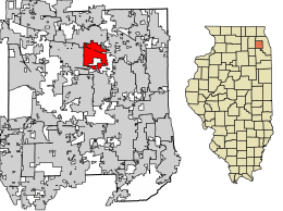
 Location of Glendale Heights in DuPage County, Illinois. | |
| Coordinates: 41°55′13″N 88°4′44″W | |
| Country | |
| State | |
| Counties | DuPage |
| Incorporated | 1959 |
| Government | |
| • Type | Council–manager |
| • President | Linda Jackson |
| Area | |
| • Total | 5.53 sq mi (14.31 km2) |
| • Land | 5.38 sq mi (13.95 km2) |
| • Water | 0.14 sq mi (0.37 km2) |
| Population (2010) | |
| • Total | 34,208 |
| • Estimate (2019)[2] | 33,617 |
| • Density | 6,242.71/sq mi (2,410.52/km2) |
| Time zone | UTC−6 (CST) |
| • Summer (DST) | UTC−5 (CDT) |
| ZIP code(s) | 60139 |
| Area code(s) | 630 and 331 |
| FIPS code | 17-29730 |
| Website | www |
| Demographics (2000)[3] | |||
|---|---|---|---|
| White | Black | Hispanic | Asian |
| 63.79% | 4.84% | 18.39% | 19.97% |
| Islander | Native | Other | |
| 0.08% | 0.30% | 8.11% | |
History
Glendale Heights was a small farming area served by the Glen Ellyn post office up until the 1950s, with a population of just 104 in 1959.[4] Midland Enterprises ran by Charles and Harold Reskin started building houses in Glendale Heights in 1958. The Reskins bought two farms on Glen Ellyn Road north of North Avenue. Houses were first built on Glen Ellyn Road and Larry Lane near Fullerton Avenue. On June 16, 1959, a petition was filed and on July 13, the village became incorporated. The first election was held later on that summer on August 2.
The town was originally named Glendale as it was between Glen Ellyn and Bloomingdale, but after a conflict arose with the small town of Glendale in Southern Illinois, the city decided in March 1960 to add the term Heights, in reference to its different topographies, a difference of about 100 feet because of its location straddling the Valparaiso Morraine, thus becoming Glendale Heights.[5]
Geography
Glendale Heights is located at 41°55′13″N 88°4′44″W (41.920228, −88.078918).[6]
According to the 2010 census, Glendale Heights has a total area of 5.51 square miles (14.27 km2), of which 5.37 square miles (13.91 km2) (or 97.46%) is land and 0.14 square miles (0.36 km2) (or 2.54%) is water.[7]
Demographics
| Historical population | |||
|---|---|---|---|
| Census | Pop. | %± | |
| 1960 | 173 | — | |
| 1970 | 11,406 | 6,493.1% | |
| 1980 | 23,251 | 103.8% | |
| 1990 | 27,973 | 20.3% | |
| 2000 | 31,765 | 13.6% | |
| 2010 | 34,208 | 7.7% | |
| Est. 2019 | 33,617 | [2] | −1.7% |
| U.S. Decennial Census[8] | |||
At the 2000 census there were 31,765 people, 10,791 households, and 7,596 families living in the village. The population density was 5,877.8 people per square mile (2,271.2/km2). There were 11,105 housing units at an average density of 2,054.9 per square mile (794.0/km2). The racial makeup of the village was 63.79% White, 4.84% African American, 0.30% Native American, 19.97% Asian, 0.08% Pacific Islander, 8.11% from other races, and 2.91% from two or more races. Hispanic or Latino of any race were 18.39%.[9] Glendale Heights has large Filipino and Asian Indian communities.
Of the 10,791 households 38.2% had children under the age of 18 living with them, 55.5% were married couples living together, 9.9% had a female householder with no husband present, and 29.6% were non-families. 22.8% of households were one person and 3.1% were one person aged 65 or older. The average household size was 2.94 and the average family size was 3.54.
The age distribution was 26.9% under the age of 18, 11.5% from 18 to 24, 36.8% from 25 to 44, 19.9% from 45 to 64, and 5.0% 65 or older. The median age was 30 years. For every 100 females, there were 104.2 males. For every 100 females age 18 and over, there were 102.1 males. Since then, the Hispanic community within Glendale heights has rapidly grown.
The median household income was $56,285 and the median family income was $64,115. Males had a median income of $40,830 versus $30,132 for females. The per capita income for the village was $21,911. About 4.7% of families and 6.1% of the population were below the poverty line, including 8.6% of those under age 18 and 7.8% of those age 65 or over.
In 2011, 22.1% of Glendale Heights's residents were Asian, making it the Chicago suburb with the fourth highest percentage of Asians.[10]
According to the U.S Census Bureau, as of 2018 the percentage of Hispanic, African American, and Asian residents had increased since 2000, while the percentage of Caucasian residents had decreased. Over the same period, the median household income was in Glendale Heights went up from 56,285 to 62,763 and the percentage people living under the poverty line increased from 8.6% to 11.1%.[11]
Schools
Glendale Heights has three school districts, 15, 16 and 41. All of these districts are K-8 and feed into Glenbard Township district 87. Though there are three school districts, there is only one library district, the Glenside Public Library District.
Queen Bee District 16
District 16 has two schools, Glen Hill and Pheasant Ridge that are K-3. Americana is for 4th and 5th grades. The middle school's name is Glenside and used to be referred to as a junior high. District 16's name sake school, Queen Bee, is no longer used as an elementary school. The building is still standing on Bloomingdale Road and used for other purposes. District 16 students are split between Glenbard North and Glenbard West for high school.
Marquardt District 15
District 15 has four elementary schools, G. Stanley Hall School, Winnebago School, Blackhawk School, and Charles G. Reskin School. The middle school, Marquardt, is the district's school. Marquardt has a separate building for the sixth grade students, and another for 7th and 8th grade students. District 15 serves the eastern part of Glendale Heights, parts of Addison, southern section of Bloomingdale, unincorporated Lombard, and the northern part of Glen Ellyn Countryside. Winnebago school has a Bloomingdale address, but sits very close to the Glendale Heights border. District 15 feeds primarily into Glenbard East High School.
Glen Ellyn School District 41
District 41 has four elementary schools, Abraham Lincoln, Benjamin Franklin, Churchill and Forest Glen. Students that live in Glendale Heights within the boundaries of District 41 attend Abraham Lincoln. Hadley Junior High is the fifth school, and it is a separate facility for students enrolled sixth, seventh and eighth grades. District 41 serves parts of Carol Stream, Glendale Heights, Glen Ellyn, Lombard and Wheaton. Students that live in Glendale Heights within the boundaries of District 41 feed into Glenbard West High School.
Notable people
- Billy Corgan, guitarist and singer of the Smashing Pumpkins, grew up in Glendale Heights.
- Jeremy Hammond, political activist, hacktivist, and anarchist, born and grew up in Glendale Heights.
References
- "2019 U.S. Gazetteer Files". United States Census Bureau. Retrieved July 14, 2020.
- "Population and Housing Unit Estimates". United States Census Bureau. May 24, 2020. Retrieved May 27, 2020.
- 2000 United States Census Data
- "History of DuPage County". Archived from the original on 2011-12-21. Retrieved 2011-09-05.
- "Several Towns Named After Founders and Heroes". The Daily Herald. December 28, 1999. p. 220. Retrieved August 17, 2014 – via Newspapers.com.

- "US Gazetteer files: 2010, 2000, and 1990". United States Census Bureau. 2011-02-12. Retrieved 2011-04-23.
- "G001 - Geographic Identifiers - 2010 Census Summary File 1". United States Census Bureau. Archived from the original on 2020-02-13. Retrieved 2015-08-03.
- "Census of Population and Housing". Census.gov. Retrieved June 4, 2015.
- "U.S. Census website". United States Census Bureau. Retrieved 2008-01-31.
- Selvam, Ashok. "Asian population booming in suburbs." Daily Herald (Arlington Heights, Illinois). March 6, 2011. Retrieved on June 19, 2013.
- "U.S. Census Bureau QuickFacts: Glendale Heights village, Illinois". www.census.gov. Retrieved 2019-05-08.

