Barrington Township, Cook County, Illinois
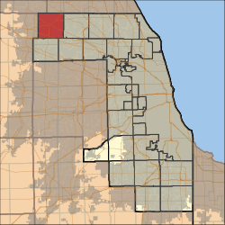
Barrington Township is one of 29 townships in Cook County, Illinois, USA. As of the 2010 census, its population was 15,636.[2] The northwestern corner of the Cook County panhandle, it is the county's northwesternmost township. It is also by far the least densely populated township in the county, with less than half the population density of the next least Lemont Township.
Barrington Township | |
|---|---|
 Location in Cook County | |
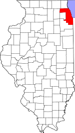
 Cook County's location in Illinois | |
| Coordinates: 42°06′41″N 88°10′46″W | |
| Country | United States |
| State | Illinois |
| County | Cook |
| Government | |
| • Supervisor | Eugene "Gene" Dawson |
| • Town Clerk | D. Robert Alberding |
| • Assessor | Amy Nykaza |
| • Tax Collector | Linda Post |
| • Trustees | Daniel Fitzgerald Robert A Nykaza, Jr. Michael W. Ryan Ronald F. Szymanski |
| Area | |
| • Total | 36.0 sq mi (93.3 km2) |
| • Land | 34.8 sq mi (90.2 km2) |
| • Water | 1.2 sq mi (3.0 km2) 3.26% |
| Elevation | 883 ft (269 m) |
| Population (2010) | |
| • Estimate (2016)[1] | 16,026 |
| • Density | 449/sq mi (173.3/km2) |
| Time zone | UTC-6 (CST) |
| • Summer (DST) | UTC-5 (CDT) |
| ZIP codes | 60010, 60118, 60192, 60195 |
| FIPS code | 17-031-03831 |
| Website | www |
Barrington Township was named after the town of Great Barrington, Massachusetts.[3]
Geography
According to the United States Census Bureau, Barrington Township covers an area of 36.0 square miles (93.3 km2); of this, 34.8 square miles (90.2 km2) is land and 1.2 square miles (3.0 km2) (3.26 percent) is water.[2]
Cities, towns, villages
- Barrington
- Barrington Hills (south three-quarters)
- East Dundee
- Hoffman Estates
- Inverness (west quarter)
- South Barrington
Cemeteries
The township contains two cemeteries: Evergreen and Union.
Major highways
Airports and landing strips
- Allstate Commercial Plaza Heliport
- Mill Rose Farm RLA Airport
- Rose Number 2 Heliport
Lakes
- Beverly Lake
- Crabtree Lake
- Dana Lake
- Goose Lake
- Hawley Lake
- Hawthorne Lake
- Heather Lake
- Keene Lake
- Lacey Lake
- Mirror Lake
- Mud Lake
- Spring Lake
- Stephanie Lake
Landmarks
- Barrington Forest Preserve (west quarter)
- Cook County-Potawatomi Woods Forest Preserve
- Crabtree Nature Center (Cook County Forest Preserve)
- Prairie Stone Business Park
School districts
- Barrington Community Unit School District 220
- Community Unit School District 300
- School District 46
Political districts
- Illinois' 6th congressional district
- State House District 52
- State House District 54
- State Senate District 26
- State Senate District 27
gollark: `# unsafely create a new scope by assigning each variable an offset in bytes from the top of the stack`This should be named `unsafe_ææææ_do_not`.
gollark: We mostly use my opinions here, which are right.
gollark: Palaiology.
gollark: I will not be accepting feedback on my opinion at this time.
gollark: Implicitly giving all functions a dedicated B-tree is helpful.
References
- "Population and Housing Unit Estimates". Retrieved June 9, 2017.
- "Geographic Identifier: 2010 Demographic Profile Data (DP-1): Barrington township, Cook County, Illinois". U.S. Census Bureau, American Factfinder. Archived from the original on February 10, 2020. Retrieved March 20, 2013.
- Chicago and North Western Railway Company (1908). A History of the Origin of the Place Names Connected with the Chicago & North Western and Chicago, St. Paul, Minneapolis & Omaha Railways. p. 41.
- "Census of Population and Housing". Census.gov. Retrieved June 4, 2016.
External links
This article is issued from Wikipedia. The text is licensed under Creative Commons - Attribution - Sharealike. Additional terms may apply for the media files.