Northern Alberta
Northern Alberta is a region located in the Canadian province of Alberta.
Northern Alberta | |
|---|---|
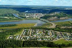
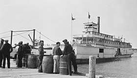
.jpg)    Left-right from top: Aurora borealis, Fort McMurray and Grande Prairie skylines, Athabasca River paddlewheeler | |
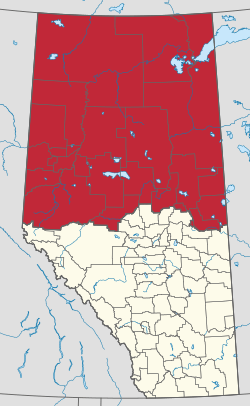
 Northern Alberta Development Council area | |
| Largest population centres | Fort McMurray Grande Prairie Cold Lake Whitecourt Peace River Slave Lake |
An informally defined cultural region, the boundaries of Northern Alberta are not fixed. Under some schemes, the region encompasses everything north of the centre of the Calgary–Edmonton Corridor, including most of the province's landmass as well as its capital, Edmonton. Other schemes place Edmonton and its surrounding farmland in Central Alberta, limiting Northern Alberta to the northern half of the province, where forestry, oil, and gas are the dominant industries.
Its primary industry is oil and gas, with large heavy oil reserves being exploited at the Athabasca oil sands and Wabasca area in the east of the region. Mostly natural gas is extracted in Peace region and Chinchaga-Rainbow areas in the west, and forestry and logging are also developed in the boreal forests of this region. As of 2011, the region had a population of approximately 386,000.[1]
Geography
Various definitions exist of Northern Alberta's boundaries. The definition used by the Northern Alberta Development Council, an agency of the provincial government, includes the communities of Whitecourt, Athabasca, Saddle Lake, St. Paul, and Cold Lake, while excluding Hinton, Edson, Mayerthorpe, and Westlock. This definition is also used by the University of Alberta to define eligibility for northern research grants.[2]
The region consists of aspen parkland in the south, grading to boreal forest and muskeg in the north.
The southwest of the region is part of the Peace Country, an area that stretches into northeastern British Columbia consisting of fertile prairie, ranchland, and farmland along the Peace River and its tributaries.
Northern Alberta is crossed by the Peace River and the Athabasca River, both of which eventually convene to form the Slave River that ultimately drains into the Arctic Ocean via Great Slave Lake and the Mackenzie River within the Northwest Territories. Other major rivers are Wapiti, Smoky, Hay, Chinchaga, Petitot Rivers in the west, Wabasca River in the center and Firebag and Clearwater River in the east. Alberta's two largest waterbodies, Lake Athabasca and Lake Claire are located in the wetlands of northeastern Alberta, forming the Peace-Athabasca Delta, that drains through the Slave River towards the Arctic Ocean.
The Caribou Mountains are an elevated plateau in the relatively flat Albertan north which provide core habitat for an endangered woodland caribou herd. This area is conserved by the Caribou Mountains Wildland Park. The adjacent Wood Buffalo National Park is Canada's largest protected area.
Other tourist attractions in Northern Alberta include the Fort McMurray Historical Society-Heritage Park, Historic Dunvegan, Kimiwan Birdwalk and Interpretive Centre, Lesser Slave Lake Bird Observatory in the Lesser Slave Lake Provincial Park, Muskoseepi Park, and the Oil Sands Discovery Centre.[3]
Northern Alberta contains several diamond bearing diatremes associated with kimberlite fields, including the Buffalo Head Hills and Birch Mountains kimberlite fields which in turn form the Northern Alberta kimberlite province.
Infrastructure
Transportation
Highway 43 and Highway 2 pass through the southwest of the region, this being the end of the CANAMEX corridor. Other important routes are the Mackenzie Highway and Bicentennial Highway in the northwest, the Northern Woods and Water Route in the southeast and Highway 63 in the east.[4]
Grande Prairie Airport, Peace River Airport, and Fort McMurray Airport are regional air transportation hubs.
Health regions
Northern Alberta's health region is controlled by Alberta Health Services.
Politics
On a provincial level, northern Alberta is represented in the Legislative Assembly of Alberta by Members of the Legislative Assembly elected in the ridings of Athabasca-Redwater, Barrhead-Morinville-Westlock, Bonnyville-Cold Lake, Dunvegan-Central Peace, Fort McMurray-Conklin, Fort McMurray-Wood Buffalo, Grande Prairie Smoky, Grande Prairie Wapiti, Lac La Biche-St. Paul, Lesser Slave Lake, and Peace River.
Communities
See also
References
- https://nadc.ca/media/1189/area-profile-an-economic-description-of-the-region.pdf
- "UofA Northern Research Awards". UAlberta North. Retrieved October 18, 2019.
- Travel Alberta. "Attractions in Alberta". Archived from the original on 2009-03-03. Retrieved 2007-01-06.
- Alberta Motor Association. "Northern Alberta - Road report". Retrieved 2007-01-11.
External links
- NADC - Northern Alberta Development Council
- Travel Alberta - Alberta North
- Alberta Regions - Alberta Heritage
- DiscoverThePeaceCountry.com featuring Villages, Towns, Cities, Parks and Lakes of Northern Alberta