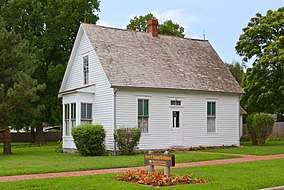
Lamar, Missouri
Lamar is a city in and the county seat of Barton County, Missouri, United States.[6] As of the 2010 census, the city population was 4,532.[7] Lamar was the birthplace of President Harry S. Truman.
Lamar, Missouri | |
|---|---|
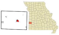 Location of Lamar, Missouri | |
| Coordinates: 37°29′37″N 94°16′20″W | |
| Country | United States |
| State | Missouri |
| County | Barton |
| Area | |
| • Total | 5.53 sq mi (14.32 km2) |
| • Land | 5.21 sq mi (13.51 km2) |
| • Water | 0.31 sq mi (0.81 km2) |
| Elevation | 961 ft (293 m) |
| Population | |
| • Total | 4,532 |
| • Estimate (2019)[3] | 4,294 |
| • Density | 823.55/sq mi (317.96/km2) |
| Time zone | UTC-6 (Central (CST)) |
| • Summer (DST) | UTC-5 (CDT) |
| ZIP code | 64759 |
| Area code(s) | 417 |
| FIPS code | 29-40376[4] |
| GNIS feature ID | 0720770[5] |
| Website | cityoflamar.org |
Geography
Lamar is located at 37°29′37″N 94°16′20″W (37.493676, -94.272111).[8] According to the United States Census Bureau, the city has a total area of 5.43 square miles (14.06 km2), of which 5.12 square miles (13.26 km2) is land and 0.31 square miles (0.80 km2) is water.[9]
History
Lamar was laid out in 1856. It was named for Mirabeau B. Lamar, second president of the Republic of Texas.[10]
Lamar underwent multiple attacks by rebels during the Civil War.
The Lynching of Jay Lynch, Age 28, took place in Lamar, Missouri on May 28, 1919. Prior to the Civil Rights era, Lamar was considered a sundown town.[11]
Demographics
| Historical population | |||
|---|---|---|---|
| Census | Pop. | %± | |
| 1880 | 907 | — | |
| 1890 | 2,860 | 215.3% | |
| 1900 | 2,737 | −4.3% | |
| 1910 | 2,316 | −15.4% | |
| 1920 | 2,255 | −2.6% | |
| 1930 | 2,381 | 5.6% | |
| 1940 | 2,992 | 25.7% | |
| 1950 | 3,233 | 8.1% | |
| 1960 | 3,608 | 11.6% | |
| 1970 | 3,760 | 4.2% | |
| 1980 | 4,053 | 7.8% | |
| 1990 | 4,168 | 2.8% | |
| 2000 | 4,425 | 6.2% | |
| 2010 | 4,532 | 2.4% | |
| Est. 2019 | 4,294 | [3] | −5.3% |
| U.S. Decennial Census | |||
2010 census
At the 2010 census there were 4,532 people, 1,866 households, and 1,202 families living in the city. The population density was 885.2 inhabitants per square mile (341.8/km2). There were 2,099 housing units at an average density of 410.0 per square mile (158.3/km2). The racial makeup of the city was 94.5% White, 0.7% African American, 0.6% Native American, 0.3% Asian, 0.7% from other races, and 3.2% from two or more races. Hispanic or Latino of any race were 1.9%.[2]
Of the 1,866 households 32.5% had children under the age of 18 living with them, 45.9% were married couples living together, 13.9% had a female householder with no husband present, 4.7% had a male householder with no wife present, and 35.6% were non-families. 31.2% of households were one person and 17.7% were one person aged 65 or older. The average household size was 2.38 and the average family size was 2.96.
The median age was 39.6 years. 25.8% of residents were under the age of 18; 8.2% were between the ages of 18 and 24; 22.3% were from 25 to 44; 24.2% were from 45 to 64; and 19.5% were 65 or older. The gender makeup of the city was 46.6% male and 53.4% female.
2000 census
At the 2000 census there were 4,425 people, 1,835 households, and 1,154 families living in the city. The population density was 1,154.5 people per square mile (446.1/km2). There were 1,995 housing units at an average density of 520.5 per square mile (201.1/km2). The racial makeup of the city was 96.61% White, 0.18% African American, 0.61% Native American, 0.34% Asian, 0.14% Pacific Islander, 0.34% from other races, and 1.79% from two or more races. Hispanic or Latino of any race were 1.40%.[4]
Of the 1,835 households 32.0% had children under the age of 18 living with them, 48.2% were married couples living together, 11.4% had a female householder with no husband present, and 37.1% were non-families. 33.3% of households were one person and 18.1% were one person aged 65 or older. The average household size was 2.35 and the average family size was 2.98.
The age distribution was 26.6% under the age of 18, 8.5% from 18 to 24, 24.9% from 25 to 44, 19.5% from 45 to 64, and 20.5% 65 or older. The median age was 37 years. For every 100 females, there were 87.2 males. For every 100 females age 18 and over, there were 80.8 males.
The median household income was $29,296 and the median family income was $38,007. Males had a median income of $26,375 versus $20,688 for females. The per capita income for the city was $15,684. About 9.7% of families and 12.1% of the population were below the poverty line, including 11.0% of those under age 18 and 17.2% of those age 65 or over.
Transportation
Lamar Municipal Airport (LLU) serves the city and surrounding communities.
Education
Public education in Lamar is administered by Lamar R-I School District, which operates Lamar High School.[12]
Lamar has a public library, a branch of the Barton County Library.[13]
Notable people
- Kid Durbin — Major League Baseball player with Chicago Cubs, Cincinnati Reds and Pittsburgh Pirates in early 20th century
- Wyatt Earp and family — famous frontier lawman
- Ed Emery — Missouri state senator and former state representative
- Joe Ihm — Missouri state representative
- Charles Henry Morgan — Missouri congressman as both a Democrat (1875–79, 1883–85) and a Republican (1909–11)
- Henry Carroll Timmonds — Missouri state representative and judge in late 19th century
- Harry S Truman — 33rd president of the United States, in office 1945–1953; elected vice president in 1944; became president upon death of Franklin Delano Roosevelt in 1945
References
- "2019 U.S. Gazetteer Files". United States Census Bureau. Retrieved July 26, 2020.
- "U.S. Census website". United States Census Bureau. Retrieved 2012-07-08.
- "Population and Housing Unit Estimates". United States Census Bureau. May 24, 2020. Retrieved May 27, 2020.
- "U.S. Census website". United States Census Bureau. Retrieved 2008-01-31.
- "US Board on Geographic Names". United States Geological Survey. 2007-10-25. Retrieved 2008-01-31.
- "Find a County". National Association of Counties. Retrieved 2011-06-07.
- "2010 City Population and Housing Occupancy Status". U.S. Census Bureau. Retrieved August 30, 2012.
- "US Gazetteer files: 2010, 2000, and 1990". United States Census Bureau. 2011-02-12. Retrieved 2011-04-23.
- "US Gazetteer files 2010". United States Census Bureau. Archived from the original on 2012-07-02. Retrieved 2012-07-08.
- Eaton, David Wolfe (1916). How Missouri Counties, Towns and Streams Were Named. The State Historical Society of Missouri. pp. 207.
- Loewen, James W. (2005). Sundown Towns : a hidden dimension of American racism. The New Press. p. 13. ISBN 156584887X.
- "Lamar R-I School District". Great Schools. Retrieved 4 June 2019.
- "Hours and Locations". Barton County Library. Retrieved 4 June 2019.
External links
- City of Lamar
- Historic maps of Lamar in the Sanborn Maps of Missouri Collection at the University of Missouri
Municipalities and communities of Barton County, Missouri, United States | ||
|---|---|---|
| Cities | 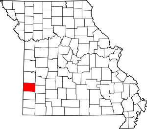 Map of Missouri highlighting Barton County | |
| Villages | ||
| Townships | ||
| CDP | ||
| Other unincorporated communities | ||
| Ghost towns | ||

| Authority control |
|
|---|